ForsythSnow
Moderator
What even are those ensembles on? E13 is just strange.
Looks like a stalled ULL in South GA..probably what will end up happening...What even are those ensembles on? E13 is just strange.
Prove it. You will be hard pressed to find it.
Sure the means are skewed by a couple random members.
No op runs.

It’s crazy thinking this upper level low is still 5-6 days from MAYBE impacting others that miss the first system
Sent from my iPhone using Tapatalk
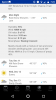
3 to 6 across Wake, and there have been op runs showing the same and more today.
You said based on what the snow maps showed. This is what they are showing. And it does go up to 6 at the Durham line. So, it really is not based on what the snow maps show when you say it is less than what they show.You mean 3-4. And plenty of sleet mixing in to bring that down to half of a snow fall map.
You said based on what the snow maps showed. This is what they are showing. And it does go up to 6 at the Durham line. So, it really is not based on what the snow maps show when you say it is less than what they show.
Ok you got me. 5-6 for that .00001% of wake.
The rest of us few million are 2-3.5 haha

Now that the pressing issue of Wake is settled ... can we?Actually Brick is right, various model runs today have shown more than 4” for Wake County. The Kuchera ratio from the 12z run of the GFS showed widespread 6” amounts. Wake will likely be in the transition zone if current modeling holds so there would be a sharp gradient if so.
View attachment 8314
Yes we can, and will.Now that the pressing isse of Wake is settled ... can we?
I would take that
Sent from my iPhone using Tapatalk
I agree .EPS still a spread tooStill a lot of different looks in there. Tells me that we still have a long ways to go to iron out the details for this storm.
I think the only counties that will see heavier totals in the upstate are Oconee, Pickens, Greenville, and Spartanburg.It’s going to be a painful four days watching extreme southern/eastern areas on the clown maps have their carpet ripped out from under them. I’m talking GA, SC and limited areas of the Carolinas. Not trying to wishcast but 9 out of 10 times it’s going to go north last minute to hammer the climo regions of the Appalachian Mountains.
I’d be very happy with that. Being in Pickens county. My little boys want some snow to play in. Guess if Sunday morning comes and it’s all rain I’ll take them to Hendersonville to playI think the only counties that will see heavier totals in the upstate are Oconee, Pickens, Greenville, and Spartanburg.
Sent from my SM-G955U using Tapatalk
Welcome to the 1/10 thIt’s going to be a painful four days watching extreme southern/eastern areas on the clown maps have their carpet ripped out from under them. I’m talking GA, SC and limited areas of the Carolinas. Not trying to wishcast but 9 out of 10 times it’s going to go north last minute to hammer the climo regions of the Appalachian Mountains.
All you have to do is drive to TR! They’ll have 10” plus!I’d be very happy with that. Being in Pickens county. My little boys want some snow to play in. Guess if Sunday morning comes and it’s all rain I’ll take them to Hendersonville to play
What is TR ?All you have to do is drive to TR! They’ll have 10” plus!
Travelers RestWhat is TR ?
I still don't feel very comfortable with the setup. Like I said this morning we are walking a thin line between a decent event and getting nothing at allWord.
I still don't feel very comfortable with the setup. Like I said this morning we are walking a thin line between a decent event and getting nothing at all
Sent from my SM-G955U using Tapatalk
I'm skeptical about large totals in Raleigh because of the likely changeover to rain in the afternoon depicted on most models.I still don't feel very comfortable with the setup. Like I said this morning we are walking a thin line between a decent event and getting nothing at all
Sent from my SM-G955U using Tapatalk


Do you have the snow total map from that?
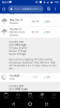
Further south again


Yeah notice the brown 1034mb line sinking into NC.
Just a small shift south but a shift.

A small shift? The southern edge went from the NC/VA line at 12z to almost CLT at 18z... That's a good chunk