• Hello, please take a minute to check out our awesome content, contributed by the wonderful members of our community. We hope you'll add your own thoughts and opinions by making a free account!

Wintry Dec 8-10th Winter Storm

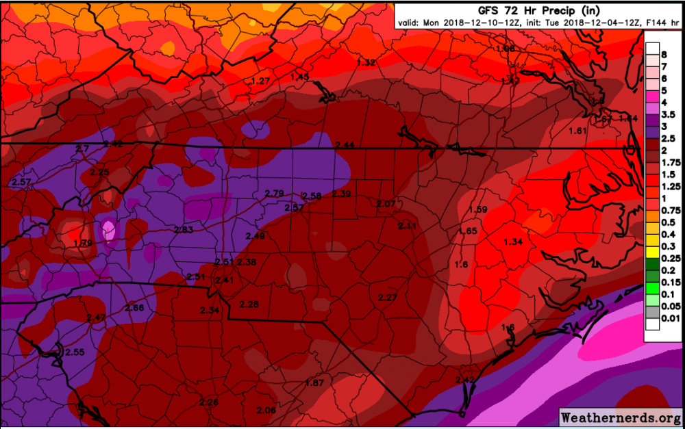
GFS showed just under 3 feet accumulation for Mt. Mitchell. Road trip?

I've thought about chasing this year (still don't have the go ahead to try overnight and won't until I talk to a friend) but I don't know about chasing in cases where the snow might be measured in feet. This one, I'll have to stream from my laptop if it works out.
 
AF9D3C8A-78FF-407A-8686-CF81323E0290.png Reality check Upstate!
 
We had an additional 3" of snow from the upper level low last December after the initial 9". So upper leve lows produce, and provide cold pockets.
 
snku_acc.us_ma.png
 
Still wanna see more cad signature (which I think we will, the GFS is going to be the last to catch up). The upper level low on the backside was a whole new wrinkle the way it was shown. Either way this could be a very good thump for the Carolinas initially, and if we get the energy to close off and sit around it’s going to pop another coastal low.
 
In all my years,of living in GA I dont recall one time getting a good snow from an ULL. ULL seems to be feast or famine. Some get a lot, others nearby get nothing.
03/01/2009...it was a Sunday 42 with rain/ sleet by noon 31 with heavy snow and thunder...Atlanta got 4.2 inches while Athens got 8 inches or more!
 
I've thought about chasing this year (still don't have the go ahead to try overnight and won't until I talk to a friend) but I don't know about chasing in cases where the snow might be measured in feet. This one, I'll have to stream from my laptop if it works out.

Mitchell ends up with anywhere between 4 to 5 inches of QPF based on the last GFS run. Nearly all of that would be snow.

image.thumb.png.547c02f49f5db24489f7ed4d12ed299a.png
 
Wow, that GFS run looked great for NC. Can't complain if you get above your average snowfall from one storm before December 15. The models have all been very positive today for here.
 
Since this storm is still about 5 days out dont that mean that this medium range and if Im correct Euro is the best at medium range.
 
The fact that some areas in nc might triple or quadruple there winter snow average is incredible and its only December, still have many storms systems this winter
 
GFS-FV3 has the high a tad weaker than the GFS.
Surface slightly colder so far however.

Good trends on the models today so far. Knew it would rebound. I think that for NE GA, it's just going to be a wait until it arrives to see how the CAD plays out since the models as mentioned seem to be horrible at handling that. If a 1037 mb high can't do the job then there has to be some insanely warm air being shoved north.
 
GFS run looked a little colder at the 850 level and the ICON, one of the warmest outliers, trended significantly colder/south. Nice consensus starting to form and I expect things to trend colder.

ICON 6z run
icon_mslp_pcpn_frzn_us_40.png


ICON 12z run
icon_mslp_pcpn_frzn_us_38.png
High 5 mb stronger on 12z, hence more S track?!! Great trend
 
Wasn't the CAD grossly underdone by models for the past two systems? I recall temperatures being 4-6 colder than modeled. Its always possible this follows that trend.
 
Well since we been seeing storms with so much qpf from this active stj, and once it's January when we reach good climo, there might be a set up much colder/bigger than this
 
FV3 is a tad more Amp’d this run. 850’s are not as cold. Pretty similar overall though. Isobars are a little deeper at 96. 2m temps are colder than 6z
 
Last edited:
Griteater says the LP on the 12Z UK exits off around Jacksonville, Fl. and then goes bonkers with a big phase. This is South of it's previous run.
Could certainly be a precursor of things to come, will not be a bit surprised if the Euro comes south today......
 
Back
Top