B
Brick Tamland
Guest
Wow, the FV3 continues to crush NC and increase the totals! Looked like the GEFS increased totals as well.
Yeah the FV3 snow maps are flawed like euro snow maps
Sent from my iPhone using Tapatalk

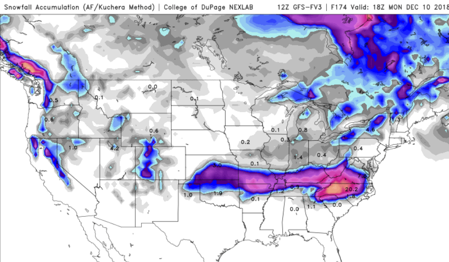
This site does a better job with it's snow maps, even has the Kuchera method for FV3.
https://weather.cod.edu/forecast/
View attachment 8115
Excellent! Thanks for the link. I wonder if we can get them to set one of the floaters to the SE for our storm???This site does a better job with it's snow maps, even has the Kuchera method for FV3.
https://weather.cod.edu/forecast/
View attachment 8115

Close up! Bricks out pants shoppingThis site does a better job with it's snow maps, even has the Kuchera method for FV3.
https://weather.cod.edu/forecast/
View attachment 8115
CMC/UK are further north with the wintery precip v/s GFS/GFSv3. Looks like Euro is the tie breaker coming up.


I notice the area shaded in blue is getting pushed further north on the latest run. Does that mean warmer air ?Looks like the Euro may follow suit w/ the rest of today's 12z guidance, note the weaker vort coming ashore on California vs yesterday's 12z run. Rut roh.
View attachment 8118
More Press in the GL and NE!?Looks like the Euro may follow suit w/ the rest of today's 12z guidance, note the weaker vort coming ashore on California vs yesterday's 12z run. Rut roh.
View attachment 8118
Good or bad?Looks like the Euro may follow suit w/ the rest of today's 12z guidance, note the weaker vort coming ashore on California vs yesterday's 12z run. Rut roh.
View attachment 8118
Differences in GFS/FV/CMC, you can see why GFS is most south and CMC most north. Look at the 50/50 lifting out quicker on the CMC. Those are the type of things that can trend very badly for us inside 72 hours. I really hope the Euro/EPS is more GFS/FV like.CMC I really don't care about. I wish the UK was more suppressed/colder though. If Euro is warmer, more north I'm not going to get my hopes up with the FV3 on an island.

Good or bad?
Remember that a weaker southern stream vort earlier on in the run leads to weaker/flatter storm in the long run, all else considered equal. It's something that folks along the I-40 & I-20 corridor should be pulling for.

Euro is not good? It must go to hades in a hand basket after this frame then..
No bueno for SAVEuro is not good? It must go to hades in a hand basket after this frame then..
Euro is not good? It must go to hades in a hand basket after this frame then..

The Pivotal Kuchera map matches up pretty well with the DuPage map...This site does a better job with it's snow maps, even has the Kuchera method for FV3.
https://weather.cod.edu/forecast/

Looks more like an icy mess on the EuroMuch warmer at 850. Boo!
Well, it's warmer at the surface too. Rain for many on this run.Looks more like an icy mess on the Euro


Yuck, yeah hard to tell with the free maps..... I was just going by still good CAD signature overallWell, it's warmer at the surface too. Rain for many on this run.