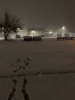
Cold Heavy Rain Cleveland TN
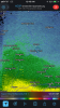
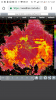
Flooding Developing 2-4" now
Deformation Band Overhead
Flooding Developing 2-4" now
Deformation Band Overhead


What about the sleet mapYeah the real test will be when the changeover will be. By morning we should know.
Yeah my inflatables are down for the countIt’s been freezing rain up here now for over 2 hours. I really hope it flips to snow cause I don’t want any power outages.
Edit: All my Christmas lights and inflatables are ice covered. Never seen that before!
It’s on the way. We are getting crushed south of 85 right now. Heavy heavy snowSnowing moderately with over 2” on the deck and lackluster reflectivity overhead, 25dbz returns inbound are keeping me up.
Where do you reside in NC?Snow is piling up quick, insane rates
Interesting, I saw my first flakes about 15 minutes or so ago in western Raleigh. Light snow coming down atm.40 here in chapel hill still waiting on 1st flake.

Glad you're in it man! Just started with really fine flakes in Wake. Wind is whipping like crazy all of the sudden and my temp has dropped 2 degrees down to 35. Pretty strong band approaching from the southwest so interested to see what happens in the next thirty minutes or so.
I was figuring that heavier band south of Wake was mixing.Heavy sleet
Sent from my SM-G955U using Tapatalk