Snowflowxxl
Member
Jimmy and Mack would have an ice issue!
.png")
.png")
 . Might be the most I've ever seen there since I moved here in 2003
Over a inch of freezing rain north of 85. That be crippling we be without power for a weekPretty serious ice threat on the NAM
They are almost always overestimated. They assume a 1:1 ratio of QPF to ice, and that almost never happens, even under ideal conditions. In this setup..with heavy precip rates (resulting in runoff) and marginal temps (upper 20s to low 30s, everything is not going to freeze on contact), I'd probably 1/3 to 1/4 some of those mapsDo ZR maps usually verify well or are they usually inflated like snowfall maps?
.thumb.png.c091e247523fb1b8be759f6bca0e8d3f.png)
It's really going to depend on how dry the air is and how much of a continued inflow of dry air there is during the precip (to aid in evaporative cooling to keep the temp below freezing). Really going to have to watch the obs to find this outPretty serious ice threat on the NAM
Also, arent temps going to be kind of marginal for ice, like in the low 30s ? Or is this a situation where it will be 25 and ice?They are almost always overestimated. They assume a 1:1 ratio of QPF to ice, and that almost never happens, even under ideal conditions. In this setup..with heavy precip rates (resulting in runoff) and marginal temps (upper 20s to low 30s, everything is not going to freeze on contact), I'd probably 1/3 to 1/4 some of those maps

Still made it to 49 today withvsleet and no sun, we just suck
NAM not entertaining the backside snow at all this run. Dry
We got it the first 50 times you said it.Looks like around 4 inches of snow with ice on top is a safe bet around my way.
Shawn based off the WRF models which is what the RPM is based off which is a very good model is showing maybe some ice in Central Midlands (Columbia). Do you think it’s possible?Some of the SREF members (that are heavily based on the NAM parameters for the most part) have been alluding to this mixed mess, even to the North lately.
Shawn based off the WRF models which is what the RPM is based off which is a very good model is showing maybe some ice in Central Midlands (Columbia). Do you think it’s possible?
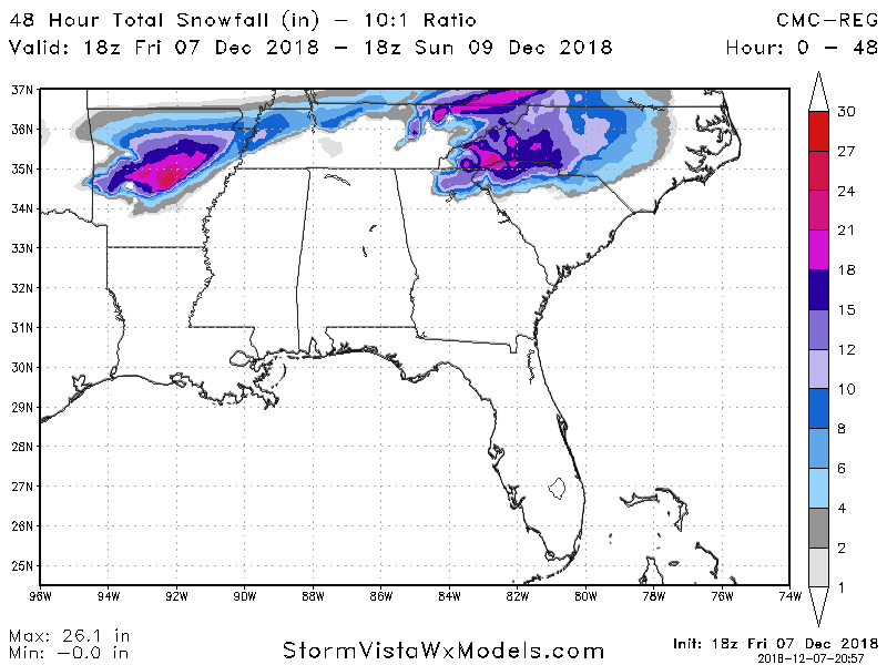
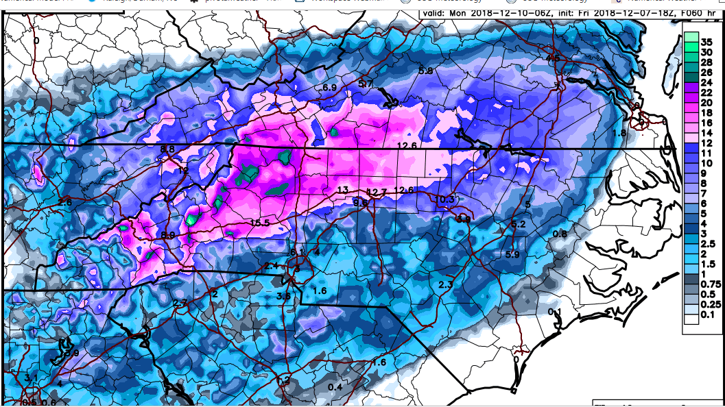
There is a sharp gradient in North vs South Fulton county in Georgia. 3 inches in North Fulton to half an inch 20 miles southLook at that gradient for Wake. And 10.3 for Durham but 3.9 for Raleigh. Looks like it has me in the 6 to 8 range.
Yess much colder.The ICON came in significantly colder.

Longtime lurker . I am wondering does anyone think Georgia( especially metro ATL) is still in play ?
We all know a lot of things can happen run. There was a vast change in the models from Sunday to Wednesday. It went from a board wide winter storm to mainly a WNC,NE GA, and Upstate South Carolina storm.
With 48-72 hours left to the storm is there a legitimate chance that accumulating snow could occur in places to the south like metro Atlanta for instance ?
The Temps in the cold rain, ZR and sleet areas are borderline.
Something like this has happened before. I remember January 2014 the models only picked up on a wintry event for mby 2 days before .
Dang, Pittsboro/Chapel Hill with 10-12. What I would give for that to verify!!!
He’s ignoring it. I know Chris justice is calling for 1-4 inches mostly sleetThis guy on Fox Carolinas!! What a bafoon! Jimmy don’t watch! He has us in flakes/to a trace on his map!could be right, but I mean does he not see the WSW!?