W
WeatherLC
Guest
what's this based on? surface temps are below freezing per namIt’s gonna be hard to get a lot of accretion @ 35 degrees
what's this based on? surface temps are below freezing per namIt’s gonna be hard to get a lot of accretion @ 35 degrees
Snow or ice, either way it would still be a big deal.
Yeah a lot of precip "wasted" moistening up the column, at onset my DP was 20 and very dry through the column.... seems to be setting up for a bad ice storm imoNam probably spends the first 6-10 hours moistening the column across central nc.
Sent from my SM-G955U using Tapatalk
No need to panic, by any means, things are still evolving and they’re changing every run there really hasn’t been much consistency in my honest opinion. I will say I don’t like the fact that the NAM has trended weaker with the high in the CAD region, no that’s not a good sign.
Again, I’m gonna repeat this again. Every single model is having consistency issues on every different run, that’s not me being overly optimistic at all it’s just saying there’s still so much unknown there’s no consistency on any of the models

TWC in house model run. Showed temps at 37 degrees from 8am Saturday-4AM Sunday, then it’s down to 32 and precip is down to showers. That doesn’t scream ice storm to mewhat's this based on? surface temps are below freezing per nam
TWC in house model run is your issueTWC in house model run. Showed temps at 37 degrees from 8am Saturday-4AM Sunday, then it’s down to 32 and precip is down to showers. That doesn’t scream ice storm to me
With this much fgen at 6z the idea of a virga storm to me is bsYeah a lot of precip "wasted" moistening up the column, at onset my DP was 20 and very dry through the column.... seems to be setting up for a bad ice storm imo


ya....that tells me something with the NAM is off on that regard this run.....With this much fgen at 6z the idea of a virga storm to me is bs
Sent from my SM-G955U using Tapatalk

Not quite. Look at the soundings. I would urge everyone to not solely lean on precip type maps. Very misleading.Nam would be a bust for western N.C. expecting 1-2ft

.png")
With this much fgen at 6z the idea of a virga storm to me is bs
Sent from my SM-G955U using Tapatalk

Just wait for that 15mb thick above freezing layer at 825mb to have you go to sleet right awayEven though the precip output says otherwise, the end of the 3km NAM run verbatim is a wet snow sounding for Charlotte with a deep isothermal layer extending up to 800 hPa and surface temps barely above freezing. As soon as warm air advection kicks in aloft, this would go over to sleet here.
View attachment 8627
")
You beat me to it lolCrazy dry nose developing on the nam at 850. It then develops a sharp 850mb front near the SC /Ga border. This means moisture inflow is stopped and we are relying on moistening from h7 down to generate precip.

Sent from my SM-G955U using Tapatalk

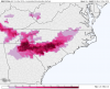
will you post a zr mapWow, gonna need to edit the colorbar on this map...11" of sleetView attachment 8630
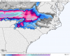
Also included the snowmap with most of the sleet removed. ZR is probably significantly overdone herewill you post a zr map


The high popping in PA , is a great thing!CAD is stronger this run but I wouldn't call this one run change a trend, it's well within the noise overall.
View attachment 8634