Is that behind a paywall?You can find the maps of hires RPM, 12km RPM, and DeepThunder (ibm's new model) at modellab.wsi.com
-
Hello, please take a minute to check out our awesome content, contributed by the wonderful members of our community. We hope you'll add your own thoughts and opinions by making a free account!
You are using an out of date browser. It may not display this or other websites correctly.
You should upgrade or use an alternative browser.
You should upgrade or use an alternative browser.
Wintry Dec 8-10th Winter Storm
- Thread starter SimeonNC
- Start date
Webberweather53
Meteorologist
The front-end thump being modeled with this storm is even more impressive than what I was seeing in NWP before Feb 2014... Yikes lol

Did we get some front end thump snow in the midlands from the Feb 2014 storm.The front-end thump being modeled with this storm is even more impressive than what I was seeing in NWP before Feb 2014... Yikes lol
View attachment 8597
Did we get some front end thump snow in the midlands from the Feb 2014 storm.
It was more of a major ZR & Sleet storm. I believe it ended as some light snow.
In my yard, we had so much sleet, it looked like it had snowed though. It was absolutely ridiculous. Probably over 2 inches or so.
Webberweather53
Meteorologist
Did we get some front end thump snow in the midlands from the Feb 2014 storm.
There wasn't much but you were forecasted to get a big ice storm and instead ended up seeing more of a sleet fest with some ZR thrown in
Webberweather53
Meteorologist
It was more of a major ZR & Sleet storm. I believe it ended as some light snow.
In my yard, we had so much sleet, it looked like it had snowed though. It was absolutely ridiculous. Probably over 2 inches or so.
Even though the actual air temperatures may not be as impressive, the cold air dam w/ this storm is even stronger than the Feb 2014 event
February 13 2014 was one of many depressing busts the past few years in North ATL lol. I think I was supposed to get 4-6"+ of snow, instead got like an inch of sleet and then got dry-slotted for the wrap-around. ATL airport 50 miles to the south got 2 inches more...
Did it shift the snow further south?EPS took pretty much everyone across the board down an inch or so. Still looks great.
Webberweather53
Meteorologist
Here's the overnight 0z EPS. Been noticing the 0z suites the last few days have taken a step back while the 12z suites take an even bigger leap forward, I wouldn't consider this a new trend per say. In another 24-36 hours or so, these ensemble runs should carry less weight in a forecast anyway because they're not properly dispersed inside 48 hours or so.
.png")
The 2 Inch mark is ever so slightly creeping to Columbia.Here's the overnight 0z EPS. Been noticing the 0z suites the last few days have taken a step back while the 12z suites take an even bigger leap forward, I wouldn't consider this a new trend per say. In another 24-36 hours or so, these ensemble runs should carry less weight in a forecast anyway because they're not properly dispersed inside 48 hours or so.
View attachment 8598
Who’s up for the Nam??
Who’s up for the Nam??
i am .. im at work until 0630
Some new data should be in these 6z runs so we shall see.
What in the.. NAM looks totally different with Low placement and even the precip @ 42 vs 00z.
Webberweather53
Meteorologist
Precipitation/virga already trying to overspread Alabama and Georgia by Friday night on this run of the NAM. Seen so many overrunning events like this (& as was alluded to by others earlier) where the initial burst of precipitation on the north side of the precip shield is more intense, more expansive than forecast, and comes sooner than modeled.
Is it further south and less cold out west?What in the.. NAM looks totally different with Low placement and even the precip @ 42 vs 00z.
Fountainguy97
Member
What in the.. NAM looks totally different with Low placement and even the precip @ 42 vs 00z.
It’s just faster than 00z.
The back end is a bit different but not that much.


Webberweather53
Meteorologist
Can't go wrong with a 1039 high parked over Snowshoe, West Virginia

Fountainguy97
Member
Can't go wrong with a 1039 high parked over Snowshoe, West Virginia
View attachment 8599
The nam is very similar in setup to fv3. The only difference is the nam has that large back side snow vs fv3 rain..
That high location is ridiculous. Wondering if it's trying to figure out where to place it... guess we will see.
Webberweather53
Meteorologist
I want whatever e8 is having.

Webberweather53
Meteorologist
The nam is very similar in setup to fv3. The only difference is the nam has that large back side snow vs fv3 rain..
Sound like a broken record, but in general this is very January 1988 esque except it's warmer overall this time around.
.png")
Brent
Member
Oklahoma City just got NAM'ed... 28 inches and still snowing :weenie:
snow in Dallas at 69 hours ooh
snow in Dallas at 69 hours ooh
sunday @ 00Z the L is right on top is New Orleans according to the NAM
Fountainguy97
Member
Nam much warmer at 850 at hr 69
Its slower, but the ice/sleet/ hammer is about to drop. should be a good chunk of nc in snow on the next frame or so.
Fountainguy97
Member
Looks a lot like fv3
Webberweather53
Meteorologist
Epic sleet fest here in KCLT on this NAM run, I can live with that.

Wow wedge is still pretty strong on 6z Nam storm track is even a lilttle more supressed.
Still shows ZR in the Midlands of SC.
Still shows ZR in the Midlands of SC.
Snowluvr
Member
Does it put Atlanta back to cold rain?
Fountainguy97
Member
Yeah nam did warm a little. It and the fv3 are very similar. That’s a good duo.
I am really beginning to get concern for Columbia and Midlands regions because Forecaster here are saying a very slim chance in far northern region for snowflake and we may actually see a major ice storm.
Webberweather53
Meteorologist
I am really beginning to get concern for Columbia and Midlands regions because Forecaster here are saying a very slim chance in far northern region for snowflake and we may actually see a major ice storm.
Lol that's usually how it goes down there w/ these events... A big ice storm seems like a legit possibility in the midlands of SC.
Brent
Member
Does it put Atlanta back to cold rain?
appears so outside of the NE side
Yellow Snow
Member
That does seem to be the case...I am really beginning to get concern for Columbia and Midlands regions because Forecaster here are saying a very slim chance in far northern region for snowflake and we may actually see a major ice storm.
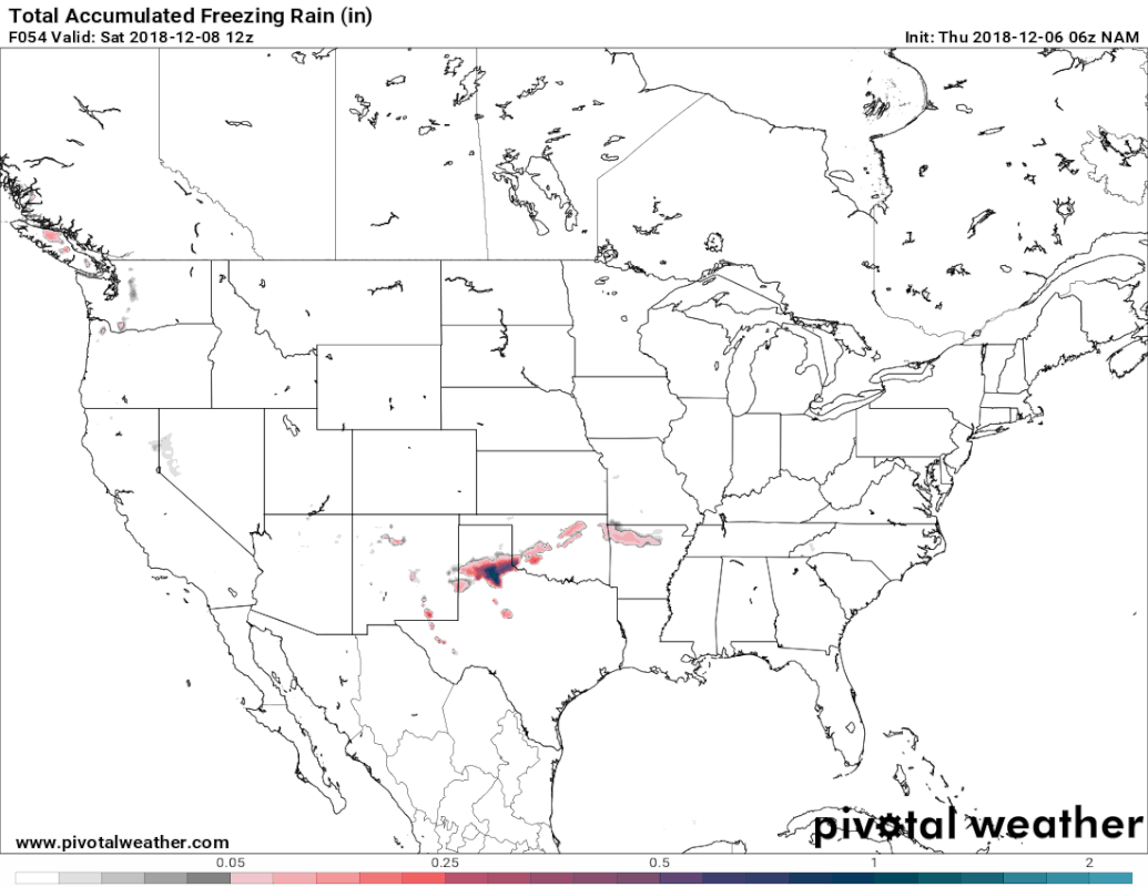
that freezing rain area looks like a mess

Lol that's usually how it goes down there w/ these events... A big ice storm seems like a legit possibility in the midlands of SC.
I understand that meso models will be able to handle the thermal structure better... It's just hard for me to believe this early.