-
Hello, please take a minute to check out our awesome content, contributed by the wonderful members of our community. We hope you'll add your own thoughts and opinions by making a free account!
You are using an out of date browser. It may not display this or other websites correctly.
You should upgrade or use an alternative browser.
You should upgrade or use an alternative browser.
Wintry Dec 21-22 street light 18z nam fantasy probably not happening but starting the thread anyway storm
- Thread starter SD
- Start date
Where are you?Weather statement notification came to me with reports of light sleet mix with rain in my area.
Webberweather53
Meteorologist
Webb you still thinking sleet with this event? Upper levels still not conductive for snow even with heavier precip?
If we get a heavier burst of precip and enough lift in the dendritic growth zone, then absolutely. I'm not too confident in this occurring except in the southern mountains near-SW of Asheville, where they could sneak an inch or so. Down over southern NC and upstate SC, temps aloft seem even more marginal for snow outside of a heavier burst here or there.
What we need to see is more warm advection like those earlier NAM runs bucking up against the colder air aloft over NC (certainly feasible knowing how these events tend to play out, perhaps the NAM overcorrected a little to the south?).
You can start having fun in these kinds of setups when the differential temperature advection that occurs across the 0°C (max temp) line aloft causes snowflakes to melt along this line, while warm advection continues unabated to the south. The end result of this is a steeper temperature gradient near the freezing/rain-snow line aloft, creating greater frontogenesis near and to the cold side of the rain-snow line, & ultimately higher precipitation rates too. Many of you likely saw this play out pretty well in December 2018 & February 2014.
Hence, when folks talk about needing to "smell the sleet" to get really good snow rates (I know @FallsLake has said this before in regards to Dec 2018), it's actually in large part because of this aforementioned physical process of differential temperature advection near the freezing line caused by melting of snowflakes juxtaposed against laterally advancing warm advection, which creates more frontogenetical forcing for ascent & heavier precip rates immediately adjacent to the rain-snow line.
NBAcentel
Member
Tho is the definition of razor thin 
- Joined
- Jan 2, 2017
- Messages
- 1,567
- Reaction score
- 4,282
Sleet reports in Montgomery AL

NBAcentel
Member
Razor thin 


Webberweather53
Meteorologist
Tho is the definition of razor thin View attachment 127680
You can also see the thicknesses increasing as the precip nudges closer. Pretty clear indication of this being WAA-driven
Webberweather53
Meteorologist
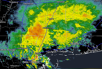
Apparently there were sleet reports today all the way down into NWS Mobile's CWA.
There is some heavier returns around Mobile.Apparently there were sleet reports today all the way down into NWS Mobile's CWA.
Attachments
- Joined
- Jan 2, 2017
- Messages
- 1,567
- Reaction score
- 4,282
Man CJ ain't lying..this evening has the look and feel of flakage

Well GSP has added a 30% chance of snow to my point forecast tomorrow night and Wednesday morning… lol
Webberweather53
Meteorologist
Rain/snow mix being reported just north of Mobile, AL down near the Gulf coast
So turning on the floodlights here wasn't being a total weenie then? And yes, I'll admit to checking Peachtree radar periodically to see if the virga ceiling is lowering ?Rain/snow mix being reported just north of Mobile, AL down near the Gulf coast

- Joined
- Jan 23, 2021
- Messages
- 4,604
- Reaction score
- 15,201
- Location
- Lebanon Township, Durham County NC
 ?
?Heelyes
Member
Bullseye over Chatham, book it
- Joined
- Jan 2, 2017
- Messages
- 1,567
- Reaction score
- 4,282
HrRRRrrr juicy

00z run should be interesting here shortly since it will go out fartherHrRRRrrr juicy
View attachment 127718
- Joined
- Jan 2, 2017
- Messages
- 1,567
- Reaction score
- 4,282
Agree..I don't think I'm getting any love but parts of NC will. But I'm betting on some novelty flakes or pellets. It seriously may be all we see down here all winter.00z run should be interesting here shortly since it will go out farther
NBAcentel
Member
Hrrr slowly inching it north the last few runs
NBAcentel
Member

Hrrr keeps coming north a bit…


NBAcentel
Member
1-2 ticks away 
If we get your typical last minute NW trend you would think some of us will get a little treat.1-2 ticks away View attachment 127727
iGRXY
Member
Something just tells me with the driver being WAA we could get some under modeled front end FGEN driven lift to get a bit wider coverage. Maybe it’s wishcasting but I’ve seen it happen plenty of times in the past.
Nam is a tick north too
NBAcentel
Member
Nam 12km is better, but the 3km is worse, and here’s the hrw fv3. So close 

SnowwxAtl
Member
Possible sleet for Atlanta?Nam 12km is better, but the 3km is worse, and here’s the hrw fv3. So close View attachment 127729View attachment 127728
NBAcentel
Member
3k. Close as well


NBAcentel
Member
This is torture 

iGRXY
Member

It’s not a ton but definitely enough to think there will be a bit more coverage
- Joined
- Jan 2, 2017
- Messages
- 1,567
- Reaction score
- 4,282
Somewhere between me and you will get vid worthy flakes hopefully. I can about guarantee Landrum gets a dusting. We got about 14hrs of slight nw ticks...lolThis is torture View attachment 127734View attachment 127735
ForsythSnow
Moderator
Between both the HRRR and NAM (whether you get sucked in or not) both got slightly colder at all levels over the last few runs in addition so a bit more saturation and some flakes may fly.
iGRXY
Member
If we can get the precip shield to shift to halfway between highway 74 and I40, that would likely put solid enough precip over most of the upstate and southern NC to get something flying for a little while.
Soon enough we’re going to need to start nowcasting. We need to see how far north that shield gets tomorrow .. if it’s as far north as the northern tip of Georgia/SC/bama we’re in business .. if it’s struggling to make it even halfway up the states .. forget it
The fact that the HRRR is picking up on this and seems to be ticking NW every hour gives me some pause. I keep thinking about that 2/6-7/2021 storm that just popped up in the last 12-18 hours with the HRRR leading the way. Now the FGEN forcing doesn’t appear to be as strong at this time, we’ve got a colder airmass in place.
 Gfs…
Gfs…00z models are pretty much a dud .. I’m going to go out on a limb here and say this one is over before it even started.
Hey.....I have the QPF, can I borrow some cold?
NBAcentel
Member
Soon enough we’re going to need to start nowcasting. We need to see how far north that shield gets tomorrow .. if it’s as far north as the northern tip of Georgia/SC/bama we’re in business .. if it’s struggling to make it even halfway up the states .. forget it
Make up your mind blud ??00z models are pretty much a dud .. I’m going to go out on a limb here and say this one is over before it even started.