- Joined
- Jan 2, 2017
- Messages
- 1,566
- Reaction score
- 4,279


Isn't this much more applicable in the Dec 23rd storm thread for North Carolina?? Just switch out GFS and NAM.Please do not get your hopes up with this. It was really just one run of a long range nam that showed some snow. Something that has no support on any other model.
Difference is it's not the long range NAM anymore. You're well within the Nam's range at 48 hours. I'd like to see more support, but this is definitely a setup that has overperformed in years past. Not saying we score, but it has some legs IMOPlease do not get your hopes up with this. It was really just one run of a long range nam that showed some snow. Something that has no support on any other model.
From what I've seen most models have trended wetter and show precip in parts of the upstate and ne ga and parts of NC for this time frame. And temp profiles have gotten cooler each run and are very close to winter precip if not already there. Yes it's not a BFD or a snowstorm were talking about but it's a legit threat at least. Those of us that are hoping the the Nam is on to something will continue to discuss. Those of you who hope it doesn't can watch the next threat for your neck of the woods. And inside 48hrs isn't long range Nam imo. You could be right but we will be ok if you are right..dont worry.Please do not get your hopes up with this. It was really just one run of a long range nam that showed some snow. Something that has no support on any other model.

Believe it or not the EPS shows support of where some sleet could fall View attachment 127554
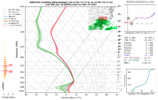
Epic pain View attachment 127563
100%. DGZs are dry in this Sounding, and that’s a hefty refreezing layer. Even though the nam was dry, I’m willing to be some sleet is gonna make it down around here tomorrow night.If we wet bulb in that sounding, it's probably sleet.
The EPS showed some activity as well that I didn’t see anyone post.
LOL: The kids getting on the polar express at the begining of the movie have more faith than we do in any model showing frozen east of the apps.The EPS showed some activity as well that I didn’t see anyone post.

