That's okay, I wasn't sure if you didn't understand the dynamics surrounding volcanoes, or didn't see the significance of the ocean cooling.I didn’t mean to be rude! I’m just not very educated in volcanoes and how the effect weather
Sent from my iPhone using Tapatalk
-
Hello, please take a minute to check out our awesome content, contributed by the wonderful members of our community. We hope you'll add your own thoughts and opinions by making a free account!
You are using an out of date browser. It may not display this or other websites correctly.
You should upgrade or use an alternative browser.
You should upgrade or use an alternative browser.
Pattern Dazzling December
- Thread starter Rain Cold
- Start date
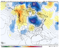
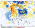
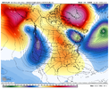
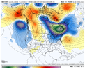
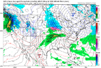
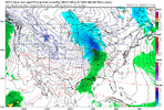
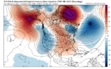
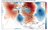
This is a great illustration of the difference it makes depending on the location of the block. Last night’s 0z has the block still centered over Greenland at this timeframe and it allows the SER to flex more, while today’s 12z the block is quicker to be centered near Baffin Bay and it forces the SER to flatten out and allow that TPV to slide underneath.
- Joined
- Jan 5, 2017
- Messages
- 3,775
- Reaction score
- 5,985
I wonder if the decreased ocean temps will lead to less water vapor in the atmosphere, dryer air overall, and less precipitation and also, more cooling as water vapor accounts for 95% of Earth's greenhouse effect. It takes a lot of energy to heat the oceans and a lot of energy must be removed in order to drop the water temp. A monster volcanic eruption and historic low solar output would do it. Reduce the water vapor, too, and look out below. CO2 concentrations are way to small to mitigate this process.That's okay, I wasn't sure if you didn't understand the dynamics surrounding volcanoes, or didn't see the significance of the ocean cooling.
Food for thought...
L
Logan Is An Idiot 02
Guest
Haven’t seen much about the 12z EPS. Was it bad?
Sent from my iPhone using Tapatalk
Sent from my iPhone using Tapatalk
NoSnowATL
Member
That’s how the last ice age started.I didn’t mean to be rude! I’m just not very educated in volcanoes and how the effect weather
Sent from my iPhone using Tapatalk
NBAcentel
Member
NBAcentel
Member
- Joined
- Jan 2, 2017
- Messages
- 1,566
- Reaction score
- 4,279
Topped out at a balmy breezy cloudy 49 today...beautiful!
BHS1975
Member
That’s how the last ice age started.
It's actually a combination of the Milancovitch cycles and CO2 removal from rock weathering processes.
Sent from my iPhone using Tapatalk
NBAcentel
Member
L
Logan Is An Idiot 02
Guest
TPV is back on our side !!! We cooking boys View attachment 124635View attachment 124636
Happy hour finally delivers
Sent from my iPhone using Tapatalk
Aleutian ridge/west coast trough couplet banging on all cylinders. Hopefully, that will abate as the run progresses.TPV is back on our side !!! We cooking boys View attachment 124635View attachment 124636
L
Logan Is An Idiot 02
Guest
Aleutian ridge/west coast trough couplet banging on all cylinders. Hopefully, that will abate as the run progresses.
Yeah. This run Doesn’t look too promising. Worse than 12z

Sent from my iPhone using Tapatalk
- Joined
- Jan 23, 2021
- Messages
- 4,603
- Reaction score
- 15,199
- Location
- Lebanon Township, Durham County NC
GFS has an ice storm for N NC this run a week from Sunday.
Pacific is a parade of troughs into the west coast. Not ideal.Yeah. This run Doesn’t look too promising. Worse than 12z
Sent from my iPhone using Tapatalk
But the block sets up at 180 with strong high pressure starting to build in.
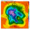
By 216, we have wedging. Nice block and 50/50 in place. Not a warm look, but until the Pacific gets repaired, it's not going to be very cold.
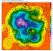
By 264, it's still not warm. The blocking has retrograded with ridging more into Canada. TT doesn't have 240 yet. Not sure where this goes, but the Pacific still looks like trash. But, there's no SE ridge in any of these images, and it should be pretty chilly, I would guess, by looking at H5.
L
Logan Is An Idiot 02
Guest
Pacific is a parade of troughs into the west coast. Not ideal.
But the block sets up at 180 with strong high pressure starting to build in.
View attachment 124637
By 216, we have wedging. Nice block and 50/50 in place. Not a warm look, but until the Pacific gets repaired, it's not going to be very cold.
View attachment 124638
By 264, it's still not warm. The blocking has retrograded with ridging more into Canada. TT doesn't have 240 yet. Not sure where this goes, but the Pacific still looks like trash. But, there's no SE ridge in any of these images, and it should be pretty chilly, I would guess, by looking at H5.
View attachment 124639
Seems like a parade of cool rains. Yet some claim the pacific doesn’t mean anything. It burns us every year
Sent from my iPhone using Tapatalk
RC - happy hour GFS didn’t deliver the goods but I’m chalking it as a baby step in the right direction
It’s hard to read your constant negativity all day long.Seems like a parade of cool rains. Yet some claim the pacific doesn’t mean anything. It burns us every year
Sent from my iPhone using Tapatalk
Webberweather53
Meteorologist
I made a nice thread on my thoughts summarizing the overall changes being seen in NWP the past few days (towards more -PNA)
I also made this nice explainer graphic for the current -EAMT event.
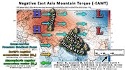
ICYMI, I also made this pair of graphics a while back explaining the basics of mountain torque & its effect on the jet stream.
Hopefully you all find some of my 2 cents and explanations helpful
I also made this nice explainer graphic for the current -EAMT event.

ICYMI, I also made this pair of graphics a while back explaining the basics of mountain torque & its effect on the jet stream.
Hopefully you all find some of my 2 cents and explanations helpful
L
Logan Is An Idiot 02
Guest
I made a nice thread on my thoughts summarizing the overall changes being seen in NWP the past few days (towards more -PNA)
I also made this nice explainer graphic for the current -EAMT event.
View attachment 124641
ICYMI, I also made this pair of graphics a while back explaining the basics of mountain torque & its effect on the jet stream.
Hopefully you all find some of my 2 cents and explanations helpful
Very helpful. Nice work Eric
Sent from my iPhone using Tapatalk
NoSnowATL
Member
Truckee, CA loving this pattern. The west coast has been winning the winters the past 5-10 years. It will switch eventually.Seems like a parade of cool rains. Yet some claim the pacific doesn’t mean anything. It burns us every year
Sent from my iPhone using Tapatalk
L
Logan Is An Idiot 02
Guest
Onto 0z. 18z GEFS is worse than 12z.

Sent from my iPhone using Tapatalk

Sent from my iPhone using Tapatalk
SnowNiner
Member
Onto 0z. 18z GEFS is worse than 12z.
Sent from my iPhone using Tapatalk
I'll still take seasonal. I'm past the 3rd stage of grief. And moved on to acceptance....., that the week of the 19th is my next week of disappointment. But that can wait until next week.
Not sure where this 'Pacific doesn't matter' narrative originated...I can't say I really see that on the board here, but maybe I'm missing it....but we need all the help we can get in all parts of the world to make it snow down here....not to mention, a lot of luck. But we certainly don't want to see a bunch of troughing up and down the west coast (a la the new 18z GEFS)Seems like a parade of cool rains. Yet some claim the pacific doesn’t mean anything. It burns us every year
But for me personally, the heavy -AO/-NAO pattern is my favorite. It doesn't always work of course, but there's something a bit mesmerizing seeing the model runs come in with that big block forming, and with the slowing of the downstream flow over the Atlantic, and with everything in the flow backing up behind it such that, in the really good ones, the entire height pattern just drops uniformly south. It's like watching a giant wreck at Talladega and all the chaos that ensues behind it.
Also, these types of patterns are associated with some of the iconic snowy and/or cold winters / periods across the south, like 1935-1936, Jan 1940, Feb-Mar 1960, Jan 1966, 1968-1969, 1969-1970, 1976-1977, 1978-1979, Jan 1982, 1995-1996, 2009-2010, Dec-Jan 2010-2011
L
Logan Is An Idiot 02
Guest
Not sure where this 'Pacific doesn't matter' narrative originated...I can't say I really see that on the board here, but maybe I'm missing it....but we need all the help we can get in all parts of the world to make it snow down here....not to mention, a lot of luck. But we certainly don't want to see a bunch of troughing up and down the west coast (a la the new 18z GEFS)
But for me personally, the heavy -AO/-NAO pattern is my favorite. It doesn't always work of course, but there's something a bit mesmerizing seeing the model runs come in with that big block forming, and with the slowing of the downstream flow over the Atlantic, and with everything in the flow backing up behind it such that, in the really good ones, the entire height pattern just drops uniformly south. It's like watching a giant wreck at Talladega and all the chaos that ensues behind it.
Also, these types of patterns are associated with some of the iconic snowy and/or cold winters / periods across the south, like 1935-1936, Jan 1940, Feb-Mar 1960, Jan 1966, 1968-1969, 1969-1970, 1976-1977, 1978-1979, Jan 1982, 1995-1996, 2009-2010, Dec-Jan 2010-2011
I Always love your posts explaining everything so well. Thank you.
Sent from my iPhone using Tapatalk
AJ1013
Member
If I ignore that it’s December it’s a beautiful evening here. 75F and breezy with a 62F dew.
Yeah history is on our side. Hopefully it progresses and we get rolling by the last 10 days of the month. It's going to be very disappointing if be manage to blow that type of block. Been over a decade since we had that and they don't come around often. We need to cash inNot sure where this 'Pacific doesn't matter' narrative originated...I can't say I really see that on the board here, but maybe I'm missing it....but we need all the help we can get in all parts of the world to make it snow down here....not to mention, a lot of luck. But we certainly don't want to see a bunch of troughing up and down the west coast (a la the new 18z GEFS)
But for me personally, the heavy -AO/-NAO pattern is my favorite. It doesn't always work of course, but there's something a bit mesmerizing seeing the model runs come in with that big block forming, and with the slowing of the downstream flow over the Atlantic, and with everything in the flow backing up behind it such that, in the really good ones, the entire height pattern just drops uniformly south. It's like watching a giant wreck at Talladega and all the chaos that ensues behind it.
Also, these types of patterns are associated with some of the iconic snowy and/or cold winters / periods across the south, like 1935-1936, Jan 1940, Feb-Mar 1960, Jan 1966, 1968-1969, 1969-1970, 1976-1977, 1978-1979, Jan 1982, 1995-1996, 2009-2010, Dec-Jan 2010-2011
AJ1013
Member
A cold christmas would be nice. Christmas extremes here range from 30F to 85F
iGRXY
Member
I think we will start seeing the effects of favorable tropical forcing as we get closer and closer. I throw next week into the trash as -PNA and west coast troughing takes hold. As we move towards the middle of December I expect our -NAO block will continue to build and we start seeing a relaxation out west. I wouldn't call for a +PNA yet as that is just rare these days it feels like, but at least a neutral PNA which honestly at this point is a win. We aren't in peak climo yet so let's not get too over board on expecting any type of winter weather until the back half of December, but I think the pattern is progressing about as well as we can hope for. Need to continue to hold the -NAO which I think is the most sure fire thing at this point. If we can keep low amp and COD MJO, then I think we have a really good shot to score towards the end of the month. We don't need the whole TPV on our side of the earth, but just a piece or 2 with some energy coming out of the Pacific Northwest and boom you're cooking with grease.
SnowNiner
Member
Not sure where this 'Pacific doesn't matter' narrative originated...I can't say I really see that on the board here, but maybe I'm missing it....but we need all the help we can get in all parts of the world to make it snow down here....not to mention, a lot of luck. But we certainly don't want to see a bunch of troughing up and down the west coast (a la the new 18z GEFS)
But for me personally, the heavy -AO/-NAO pattern is my favorite. It doesn't always work of course, but there's something a bit mesmerizing seeing the model runs come in with that big block forming, and with the slowing of the downstream flow over the Atlantic, and with everything in the flow backing up behind it such that, in the really good ones, the entire height pattern just drops uniformly south. It's like watching a giant wreck at Talladega and all the chaos that ensues behind it.
Also, these types of patterns are associated with some of the iconic snowy and/or cold winters / periods across the south, like 1935-1936, Jan 1940, Feb-Mar 1960, Jan 1966, 1968-1969, 1969-1970, 1976-1977, 1978-1979, Jan 1982, 1995-1996, 2009-2010, Dec-Jan 2010-2011
My hope is we can win in this -NAO regime, and that it lines up the way it should, the TPV sets up where it should despite the west not being great. It can't be awful with a huge pacific low for sure. But I just doubt we'll have a great block AND a good pacific at the same time. Even 9-10 had a not so great pacific.
Right now the Atlantic seems our best shot. We'll likely need to deal with that and hope the pacific doesn't kill it too bad. My guess is when the pacific really improves significantly, the block may be gone. Thats all a bit anecdotal I know, but just from my past weenie experience of not having both sides in our favor.
Most recent events we've had seem to have originated from a good pacific and good timing. So honestly I'm not sure what to root for anymore.
L
Logan Is An Idiot 02
Guest
What a premature thing to do by accuweather.

Sent from my iPhone using Tapatalk

Sent from my iPhone using Tapatalk
I tend to root for the -NAO/-AO combo. As grits post above shows historically it works. I remember reading on here that usually the forces that cause a -NAO usually destroy the -EPO and vise versa. So I does seem really hard to get a great Pacific with a Great Atlantic. Give me the great Atlantic and a ok Pacific and let's roll the dice.My hope is we can win in this -NAO regime, and that it lines up the way it should, the TPV sets up where it should despite the west not being great. It can't be awful with a huge pacific low for sure. But I just doubt we'll have a great block AND a good pacific at the same time. Even 9-10 had a not so great pacific.
Right now the Atlantic seems our best shot. We'll likely need to deal with that and hope the pacific doesn't kill it too bad. My guess is when the pacific really improves significantly, the block may be gone. Thats all a bit anecdotal I know, but just from my past weenie experience of not having both sides in our favor.
Most recent events we've had seem to have originated from a good pacific and good timing. So honestly I'm not sure what to root for anymore.
NBAcentel
Member
EPS went the right direction at 18z with a more separated TPV from the energy diving out of Alaska. Let’s hope this is a sign of things to come for tonight’s runs
DadOfJax
Member
Literally what you have been whining about for days….that just made a map of everything you’ve been saying.What a premature thing to do by accuweather.
Sent from my iPhone using Tapatalk
I would not give up on some winter action here in NC around the middle of the month. The models have been showing a storm here around that time for at least one run the past few days.
severestorm
Member
They left some parts of the US out ?What a premature thing to do by accuweather.
Sent from my iPhone using Tapatalk
LukeBarrette
im north of 90% of people on here so yeah
Meteorology Student
Member
2024 Supporter
2017-2023 Supporter
Beautiful
A big ole closed off 588 subtropical ridge over Florida. Can't get a more textbook SER.

