- Joined
- Jan 23, 2021
- Messages
- 4,603
- Reaction score
- 15,199
- Location
- Lebanon Township, Durham County NC
Just coming in from taking the dogs for their morning walk and there is actually some light sleet here too. Definitely was not expecting that.Just hit a random sleet shower on the way to work. Winter's back on the menu.View attachment 124611
Just coming in from taking the dogs for their morning walk and there is actually some light sleet here too. Definitely was not expecting that.
Edit: and now some snowflakes flying around too. WTH?
2nd earliest I’ve seen snow falling since I moved in this house. The only year earlier was in November 2013 and that ended being a pretty good winter… last time I finished in double digitsThe universes payment for knocking us back a week or two.

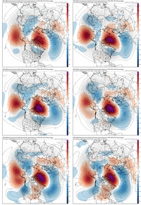
Despite the milquetoast 00z runs i still like the look, pacific vort leapfrogging over an omega block is how i received the most snow i've ever seen in my life (remarkably on my first night on air when i was a broadcast met, lol). I think that small changes (stronger NE vortex pushing the SW south, more digging ) in this case can still yield an event worth tracking. Then again, it's December 2nd, it's basically Week 1 in NFL terms, I'm not in midseason form yet, also likely this is a nothingburger event.GEFS still has some interest in next Friday
I don't think it's an unpopular opinion for most of us. It's ok to be cautiously optimistic because we have a true -NAO coming. But it's also important to realize that there are many things that can go wrong. Some of the modeling the last 24 hrs has shown some of those things. But like you said it's still more than 10 days out and model skill is very low and either outcome is just as likely at this point. I don't personally think it'll get that cold like 2010 did. But cold enough to get the job done is possible. But fighting the SER and not even coming close to getting anything wintry is still a possibility as well.I know this won't be popular but honestly, I am not too encouraged by the recent trends. Looks awfully familiar to 2021. Not only that, but the mirage that always exist beyond about D10-11 that slowly fades as models move towards and into truncation is real.
Notice what happens as more and more of the TPV that was once modeled to slide southeast starts being modeled inside of truncation hours. This happens over and over and over again and I fall for it every time. Something about the TPV is just not modeled correctly at these lower model resolutions, which is why these same trends are showing up in every modeling suite at the same forecast time.
View attachment 124609
Unless positive trends are occurring inside of model truncation, getting encouraged is a pretty risky bet. Without some TPV moving under the Greenland ridging, you don't have a functioning -NAO and we're basically waiting for another opportunity to reset the pattern.
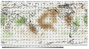
I'm still hopeful that eventually we can push through this "model mirage" into something better, but with the MJO exerting only minor influence it's going to take something else to force this. It is encouraging that we have Greenland blocking consistently showing up, so maybe it's just a matter of time until we can get a series of undercutting storms, cross polar flow and a -EPO to help establish a cold regime.
Mood flakes this time of year is a win, which I am sure you'll agree with.Despite the milquetoast 00z runs i still like the look, pacific vort leapfrogging over an omega block is how i received the most snow i've ever seen in my life (remarkably on my first night on air when i was a broadcast met, lol). I think that small changes (stronger NE vortex pushing the SW south, more digging ) in this case can still yield an event worth tracking. Then again, it's December 2nd, it's basically Week 1 in NFL terms, I'm not in midseason form yet, also likely this is a nothingburger event.
with how the last decade or two has gone anything before christmas is a fat W. that dec 8 2018 event was so out of the ordinaryMood flakes this time of year is a win, which I am sure you'll agree with.
I know this won't be popular but honestly, I am not too encouraged by the recent trends. Looks awfully familiar to 2021. Not only that, but the mirage that always exist beyond about D10-11 that slowly fades as models move towards and into truncation is real.
Notice what happens as more and more of the TPV that was once modeled to slide southeast starts being modeled inside of truncation hours. This happens over and over and over again and I fall for it every time. Something about the TPV is just not modeled correctly at these lower model resolutions, which is why these same trends are showing up in every modeling suite at the same forecast time.
View attachment 124609
Unless positive trends are occurring inside of model truncation, getting encouraged is a pretty risky bet. Without some TPV moving under the Greenland ridging, you don't have a functioning -NAO and we're basically waiting for another opportunity to reset the pattern.
I'm still hopeful that eventually we can push through this "model mirage" into something better, but with the MJO exerting only minor influence it's going to take something else to force this. It is encouraging that we have Greenland blocking consistently showing up, so maybe it's just a matter of time until we can get a series of undercutting storms, cross polar flow and a -EPO to help establish a cold regime.
What a depressing evolution the icon has. The TPV completely leaves Canada and we’re left with ---- air under the block View attachment 124615
The models have literally bounced back and forth. I wouldn’t call any of them a real trend.Sadly that has been a trend in most of the models.
Sent from my iPhone using Tapatalk
The models have literally bounced back and forth. I wouldn’t call any of them a real trend.
All great points. With the blocking that is developing, things are often a bit of a step down process. That’s why I’ve always been convinced that the potential for late next week and next weekend is a threat for the northeast. Again though I don’t think that’s a bad thing, because I would really like to see a good snowpack get in place up there as we approach what I think will be the time frame that we could see some potential… that time has always been from about the 15th on.Model flipping, especially during a pattern change, especially beyond 8-10 days is just going to be a given. Things on our side is a true -NAO with strong confluence in the 50/50 area. MJO progression is favorable. That to me is the biggest key here and why these bad model runs aren't moving me right now. We may not get a true +PNA with a true double blocking bridge over the North Pole but a relaxed pacific and even just a neutral PNA I think has a better shot than all the cold air dumping out west like 2021. Now with that said, I still say that this first big block is just setting the stage for the real time frame which is the last 10-14 days of December. Blocks this strong usually are stubborn and just reintensify, generally the 2nd stage of a big block is when we score anyways as the initial cold and progression is favorable for the NE/MA which we want to happen first anyways. And finally, we will be getting deeper into above average climo and closing in on Peak Climo which is the first couple of weeks of January. We may not score at all, but there's A LOT of favorability on our side that says at least the back half of December and front half of January to get a winter storm or 2.
Ole carrot dangling front the donkey process I call it. Until things start changing in the pacific. Good luckAll great points. With the blocking that is developing, things are often a bit of a step down process. That’s why I’ve always been convinced that the potential for late next week and next weekend is a threat for the northeast. Again though I don’t think that’s a bad thing, because I would really like to see a good snowpack get in place up there as we approach what I think will be the time frame that we could see some potential… that time has always been from about the 15th on.
Ole carrot dangling front the donkey process I call it. Until things start changing in the pacific. Good luck
For your area probably, but not for this side of the Apps. We can score in -PNA times due to CAD.Ole carrot dangling front the donkey process I call it. Until things start changing in the pacific. Good luck
and that that’s why I’m looking at from the 15th and onward… that’s when the PNA looks to go to about -.5 to -.7Agree with you 100%. That PNA needs to get close to neutral
Sent from my iPhone using Tapatalk
and that that’s why I’m looking at from the 15th and onward… that’s when the PNA looks to go to about -.5 to -.7
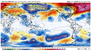
The block is still a bit too far to the east which allows the SER ridge to flex some. I have a feeling though that much like how later this weekend and early next week was supposed to torch a few days ago, we’ll see these come back in line closer to seasonalThis is the weirdest ------- 500mb pattern I’ve ever seen that’s somehow torching us View attachment 124616
How far east is it?The block is still a bit too far to the east which allows the SER ridge to flex some. I have a feeling though that much like how later this weekend and early next week was supposed to torch a few days ago, we’ll see these come back in line closer to seasonal
It’s centered basically over southern Greenland. The best location for it to be to keep the SER in check is near Baffin Bay. It’s still backing to the west at this point so that’s why it’s gonna take a few more days after this to really do us any good. This step down process that’s really interesting to watch developHow far east is it?
And the days are getting shorter. Lol, at least we got that going for us for 3 more weeks.On a bright side the 06z CFS was mighty chilly
Sent from my iPhone using Tapatalk

I agree. Obviously I’d prefer to be cold in December but it really is much harder to get snow in December than in January in the southeast. Last few years it’s been torch city in December followed by cold January and at least some of February. I’m not sure how this season will unfold but I’d rather it be warm now and much of December then in January.Im fine with December being slow to switch over in the eastern US. It’s gonna happen eventually and I hope it’s for Jan and Feb which is Climo for a lot on the board.


Moving nicely along to AcceptanceI agree. Obviously I’d prefer to be cold in December but it really is much harder to get snow in December than in January in the southeast. Last few years it’s been torch city in December followed by cold January and at least some of February. I’m not sure how this season will unfold but I’d rather it be warm now and much of December then in January.

Good! Goooood!!!!!!!!!
Yes I agree. But…what are the chances we are having this same conversation on the 15th about a switch beginning of January lol. Seems like it never ends.Medium range is gross on the GEFS and GFS but a solid switch around day 10 until the end of the runs. Makes sense right now. 12/12-12/15 looks like a good timeframe to switch and pushes us into the back half of December.
