I hope we can get some frozen here at the crystal coast....it's one of the drawbacks of seeing the ocean out my back door.
-
Hello, please take a minute to check out our awesome content, contributed by the wonderful members of our community. We hope you'll add your own thoughts and opinions by making a free account!
You are using an out of date browser. It may not display this or other websites correctly.
You should upgrade or use an alternative browser.
You should upgrade or use an alternative browser.
Pattern Dazzling December
- Thread starter Rain Cold
- Start date
NWMSGuy
Member
I’ll go as far as saying there may be a flake or two that flys around Memphis area with the system moving through Monday.

packfan98
Moderator
I’ve never seen icon verification scores before. Seems to be right there with the GFS.
- Joined
- Jan 23, 2021
- Messages
- 4,604
- Reaction score
- 15,203
- Location
- Lebanon Township, Durham County NC
I’ve never seen icon verification scores before. Seems to be right there with the GFS.
I’d always wondered about that. Also, look at that precipitous drop in GFS scores.
Definitely not at this point. We got one round of NAM runs. NAM is known to head fake in the long range. We need consecutive runs and additional support from other models.Tuesday storm needs its own thread. It's legit. Really all we need is a little stronger forcing and expansive precip shield to the north, and these weak gulf lows usually have that. I'm all in
rburrel2
Member
Gfs, euro, icon, etc all have precip making in to upstate, SC on Tuesday. NAM might be the only model showing a North Carolina hit right now but I don’t think this is a NC only board right?Definitely not at this point. We got one round of NAM runs. NAM is known to head fake in the long range. We need consecutive runs and additional support from other models.
Snownut
Member
It's pretty much a NC only BoardGfs, euro, icon, etc all have precip making in to upstate, SC on Tuesday. NAM might be the only model showing a North Carolina hit right now but I don’t think this is a NC only board right?
Sent from my SM-A526U using Tapatalk
Correct but more than likely you will be too warm in SC for anything more than maybe a quick flake before 850s warm above freezing. Further into NC would have a better chance at a longer initial winter precip time IF precip actually made it up there.Gfs, euro, icon, etc all have precip making in to upstate, SC on Tuesday. NAM might be the only model showing a North Carolina hit right now but I don’t think this is a NC only board right?
GFS not seeing this though right? Just the ICON?Correct but more than likely you will be too warm in SC for anything more than maybe a quick flake before 850s warm above freezing. Further into NC would have a better chance at a longer initial winter precip time IF precip actually made it up there.
- Joined
- Jan 2, 2017
- Messages
- 1,568
- Reaction score
- 4,283
I will say that we should watch to see how good the FGEN forcing looks to be. If it’s strong enough it could very easily crash 850s even in a very marginal set up. Right now there seems to be some decent looks on the soundings for northern SCCorrect but more than likely you will be too warm in SC for anything more than maybe a quick flake before 850s warm above freezing. Further into NC would have a better chance at a longer initial winter precip time IF precip actually made it up there.

severestorm
Member
Please don't buy into that guy, he's a wishcaster. The storm will cut.
Yep, it's on it's way to cutting off in future NAM frames (not far even)
Swing and miss on the Icon. If the crazy GFS doesn’t show anything I think we can bury the Christmas chance and have to bank on a Hail Mary around the 27th.
1068Mb high into Montana Thursday morning. Now that's something you don't see very often.
I am not expecting any snow out of this pattern. I am expecting very cold temperatures and a wild and crazy meteorology day Friday. I am probably going to see really cold temperatures and a really cool meteorology day on Friday. My expectations will be met and I will be happy. When I don’t expect snow to fall and none ends up falling my feeling will be neutral to that fact and i will have a net positive feeling about everything. This is protecting my mental health.
Wide right
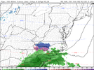
Trending NW good point at this stage. Looking at 500mb their would be more precip NW of the low.Wide rightView attachment 127534
Did anyone seen the 18z Navgem headed to glory at the end of run.
Low pressure coming up from us Thursday would have to end up being the main low taking over .. therefor we need the primary low to shift 900 miles east of what general consensus among models is. Also meaning .. this probably is not happening lolDid anyone seen the 18z Navgem headed to glory at the end of run.
Pilotwx
Member
Cold ( high pressure) coming out of the NW to upper MID West with a NW flow for NC, SC, and VA. Always means dry air masses and usually a delay in the cold making it over the mountains. COLD / chasing moisture
As of today Greensboro is -.03 BN for the month. Its a given we will average Below Normal on temps for the month of December, especially with Much Below Normal temps forecasted from here on out.
This will be one the coldest Decembers here in over a decade when all is said and done.
This will be one the coldest Decembers here in over a decade when all is said and done.
Cad Wedge NC
Member
Down to 20.1 degrees this morning..... didn't realize we were going to get that cold.
20.5. I need to pour some concrete and this isn’t helping.
Met1985
Member
13 degrees this morning. Coldest morning of the season.
NoSnowATL
Member
36. 1st morning that I had to warm up the car.
Emerson, my brother! You picked the wrong week to pour concrete.20.5. I need to pour some concrete and this isn’t helping.

NBAcentel
Member
22 degrees this morning, one of the coldest mornings this met winter
Momma wants the kids play set done so I guess I’ll be looking into ad mixtures
Blue_Ridge_Escarpment
Member
If mama ain’t happy, ain’t nobody happy.Momma wants the kids play set done so I guess I’ll be looking into ad mixtures
NCHighCountryWX
Member
- Joined
- Dec 28, 2016
- Messages
- 700
- Reaction score
- 1,921
Prepare for the polar vortex to wind up tight as a top going into January and Judah this morning discusses even Siberia torching.
Get ready for delay delay delay
Get ready for delay delay delay
iGRXY
Member

packfan98
Moderator
Clear trends in the right direction with more digging in the sw and faster movement NE with the first system. Still not seeing much at the surface. Hopefully we can get some ensembles to start popping a little.
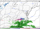
Just a reminder that it can always be worse. We are hard to please sometimes. Enjoy your cold. We don’t get it centered around the holidays very often.
OrJust a reminder that it can always be worse. We are hard to please sometimes. Enjoy your cold. We don’t get it centered around the holidays very often.View attachment 127608
That jet extension.png")
NBAcentel
Member
That CWB from the big storm this week, could set off another -NAO event. Problem as usual is the pacific - hyper pacific jet 