Where is everybody?
Some of us are just waiting to see if we get in the game or end up with a pile of cool rain.
Give me a little more west coast ridging…
Where is everybody?
My excitement meter for a day 9 threat is pinging at about a 9 out of 10 right now... When the 00z GEFS/EPS/CMCE means come in showing multiple inches of snow tonight i'll be at 10/10.
Also, it's always nice to have great potential out past a threat to fall back on, and we absolutely have that going for us too. Good time to be a snow weenie.
When you have to say let’s get it under a week you’ve said it all lol.Bruh, yeah interest is peaked….but it’s so far out…and it wouldn’t take much NW trend for this to be a big rain storm imo. SE ridge is on all models so I’m just gonna marinate, wait and watch. It’s going to take a heck of a cad to get a strong winter storm with as strong as the storm looks. I’d like to see more trough and less SE ridging the next 3 days.
Ensembles are improving but not great imo. Let’s get it under a week and see where it is.
Might be the first time those words have ever been spoken in the history of model-watchingAnd here came the 18z GFS to output reality.
I'm just happy we have something to look at under 10 days.When you have to say let’s get it under a week you’ve said it all lol.

The 1st reversal of trends. By tomorrow morning all of this cold and snow the models are showing will be gone.This GFS run isn’t gonna be great due to that out of nowhere TPV getting injected into the main trough out west, but not sweating it
Are you 12?My excitement meter for a day 9 threat is pinging at about a 9 out of 10 right now... When the 00z GEFS/EPS/CMCE means come in showing multiple inches of snow tonight i'll be at 10/10.
Also, it's always nice to have great potential out past a threat to fall back on, and we absolutely have that going for us too. Good time to be a snow weenie.
The new GFS says the ridge wins out and it's hard to go against it. We are going to probably end up with a warm and dry Feb and March. That southeast ridge is not going anywhere.Bruh, yeah interest is peaked….but it’s so far out…and it wouldn’t take much NW trend for this to be a big rain storm imo. SE ridge is on all models so I’m just gonna marinate, wait and watch. It’s going to take a heck of a cad to get a strong winter storm with as strong as the storm looks. I’d like to see more trough and less SE ridging the next 3 days.
Ensembles are improving but not great imo. Let’s get it under a week and see where it is.
I was 12 when I started following weather forums 13 years ago, don’t be too hard he could be and that’s ok! Many of our members started here at that age roughly, I think Ollie was around that age and now he is in met school!Are you 12?
I'm here till the bitter end.Where is everybody?
I've been wondering the same thing about you.Are you 12?
From 12 to 1503 year old metwannabe we got a great group!I'm here till the bitter end.
I've been wondering the same thing about you.
Hey Lick. Going to be enjoying the warm weather next week thinking about you.I was 12 when I started following weather forums 13 years ago, don’t be too hard he could be and that’s ok! Many of our members started here at that age roughly, I think Ollie was around that age and now he is in met school!
Enjoy, your blue devils doing great! Looks chilly after so take it all inHey Lick. Going to be enjoying the warm weather next week thinking about you.
sorry I cant read ignored content.Are you 12?
Thanks buddyEnjoy, your blue devils doing great! Looks chilly after so take it all in

Me and some buddies are going to see Wembanyama play in Charlotte on Friday. I’m hammering his prop overs.
Quick…. Someone ask this guy what happens in 10 days so we can all just find out
Sent from my iPhone using Tapatalk
You must have read it, You responded LMAO!! Yeah you 12 may even be 5?sorry I cant read ignored content.
If you live in Central SC I would not have my excitement at a 9/10My excitement meter for a day 9 threat is pinging at about a 9 out of 10 right now... When the 00z GEFS/EPS/CMCE means come in showing multiple inches of snow tonight i'll be at 10/10.
Also, it's always nice to have great potential out past a threat to fall back on, and we absolutely have that going for us too. Good time to be a snow weenie.
The town of Central, SC is near ClemsonIf you live in Central SC I would not have my excitement at a 9/10
Oh wow that’s kinda misleading. Someone should do something about thatThe town of Central, SC is near Clemson
Yeah all he has to do is put Upstate SC out beside it. Pretty simpleOh wow that’s kinda misleading. Someone should do something about that

Just under 9…but I make up for it with persistence.Are you 12?
Me and some buddies are going to see Wembanyama play in Charlotte on Friday. I’m hammering his prop overs.
9nm is impressive work indeed! More power to you, 9nm at 90 miles an hour is hell!Just under 9…but I make up for it with persistence.
Soil temps already in the 50's in North GA. Going to apply pre emergent this week I think.


wasn’t it you who was hyping this time period up and even bragging about it earlier lolIDK why people are thinking this thing won't go to the mid ATL and NE. Even the footprint of modeling and the ZR and Sleet was showing the idea..
What happened to the NW trend people for every other event?
The 18z GFS seems more realistic to me. Guess we will have to see.
That be Burrelwasn’t it you who was hyping this time period up and even bragging about it earlier lol
I mean, I expected a storm to show on the models for the 9-15 range. Didn't say it would happen. The footprint of the models has sucked and had a bullseye North of the SE for a while me thinks. I guess one could wish for a fringe ice or something? IDK.wasn’t it you who was hyping this time period up and even bragging about it earlier lol

Well worst case, we lay the base for the late February CAD feed.Biblical run for the Mid Atlantic. They couldn’t miss if they tried View attachment 167593
Yea id rather not get another flake than watch those crybabys get another decade level storm. They cry every year in their forums and barely even track a 3-6" event but will all show up for this. Thats called being a bandwagon fanBiblical run for the Mid Atlantic. They couldn’t miss if they tried View attachment 167593
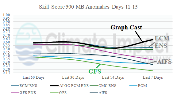
What is Hilarious (yes we do the same) but Big Bastard(i) is only posting GFS runs over n over on twitter and talking about MA/NE. None of them will even acknowledge the EURO A.I, And as it shows here.....they should. I will never doubt EURO A.I 5-8 Days out , NAM 48hRS Anymore.... Hopefully some semblance of the old EE Rule comes back in years to comeSome interesting fresh data on verification scores published yesterday. GFS sucks guys.
AI Graph Cast ECM ENS Becoming No. 1 Performing Model across North America in Medium-range - Climate Impact Company
Chart of the Day - AI Graph Cast ECM ENS Becoming No. 1 Performing Model across North America in Medium-rangeclimateimpactcompany.com
Yea, this is sorta like last week when the GFS was showing ice storms here with epic wedging in the day 8-10 timeframe... and the Euro AI had the freezing line up in Maine with hardly any semblance of a wedge... Euro AI never flinched and was completely accurate in the end.What is Hilarious (yes we do the same) but Big Bastard(i) is only posting GFS runs over n over on twitter and talking about MA/NE. None of them will even acknowledge the EURO A.I, And as it shows here.....they should. I will never doubt EURO A.I 5-8 Days out , NAM 48hRS Anymore.... Hopefully some semblance of the old EE Rule comes back in years to come


