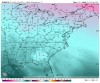
• Hello, please take a minute to check out our awesome content, contributed by the wonderful members of our community. We hope you'll add your own thoughts and opinions by making a free account!

Pattern Caperil 2021

The past several years have left a lot to be desired for severe weather in April.

But trends can die hard and I like your optimism.

The Easter Weekend Outbreak was very intense. In fact, In South Carolina, it produced the strongest tornado in the Charleston WFO of responsibily EF4 (only one on record) at the most unclimatologically favored time of day...and unfortunately several fatalities with that parent supercell which would produce another strong EF3 in the Monck's Corner area around 8am...
11 tornadoes from the parent, 10 in SC and another 3 offshore including a Doppler radar indicated powerhouse.
 

The CMC cold bias is laughable. A 21 low on Saturday in Concord, NC? It really is the Crazy Uncle of models. We'll see how far off they end up being. I mean this model is way over-radiating so badly that it is leaving Hogtown type radiation in the dust! @pcbjr

NWS forecast:
FRIDAY NIGHT
CLEAR. LOWS IN THE LOWER 30S.


*Corrected
 
Last edited:
I guess this coming cold snap would be Dogwood Winter. So, I'm guessing sometime in late April, we'll have Locust Winter. Then we get Blackberry Winter in May... then that's it... it will be off to endless summer!
 
I guess this coming cold snap would be Dogwood Winter. So, I'm guessing sometime in late April, we'll have Locust Winter. Then we get Blackberry Winter in May... then that's it... it will be off to endless summer!

No, it is Indian winter.

GSP has an interesting discussion about wintry possibilities for the mountains:


CONCERNS TURN TO WINTRY WEATHER BEHIND THE FRONT, AS 850 MB
TEMPS CRASH FROM +11-12 DEG C AT 21Z TO 0 TO -2 DEG C BY 03Z, AND
CONTINUES FALLING THRU THE NIGHT. THERE WILL BE ENOUGH MOISTURE
FOR NW FLOW SHOWERS WEDNESDAY NIGHT, LINGERING INTO THURSDAY ALONG
THE TN BORDER. CONFIDENCE ON SNOW ACCUMS IS STILL LOW, BUT COULD
SEE 1-3" OF SNOWFALL IN THE HIGHEST ELEVATIONS. STRONG WINDS MAY
ALSO APPROACH WIND ADVISORY CRITERIA OVERNIGHT, WITH A SIGNAL
FOR STRONG CHANNELING OF FLOW UP THE FRENCH BROAD VALLEY ON THE
NAM. IT WILL REMAIN WINDY DURING THE DAY THURSDAY, AS POLAR HIGH
PRESSURE BUILDS IN FROM THE NW. TEMPS WILL BE ABOUT 5 DEG ABOVE
NORMAL WEDNESDAY, FALL TO 2-5 DEG BELOW NORMAL WEDNESDAY NIGHT,
THEN WARM TO ONLY 15-20 DEG BELOW NORMAL THURSDAY (HIGHS WE'D
EXPECT IN EARLY FEBRUARY).
 
Below is the laughable 12Z CMC for Saturday morning, the second of the two cold ones due to excellent radiation. It isn't on crack. Rather, it is quite sober and is just a bad, strongly cold biased model...it even has a freeze for a small part of NW FL lmao:

canop_12_t2ms_gc_h_0096.png
 

Been there, done that last week here...actually even hotter. :) So having that here wouldn't be a shocker. Now up your way that would be impressive. And such a cold biased model showing that heat is notable. But this is merely the highly unreliable day 10 of the operational Crazy Uncle. So, I wouldn't go to Vegas and bet on this level of heat up your way just yet.
 
It could really get warm after this cool down, really nice setup to bake if any boundary hangs to our NE

Regardless of the cold start, April will still likely be another warmer than normal month in the SE because that's GW related climo, bro.

Edit for @Myfrotho704_ : Actually, I expect Apri-Aug at a minimum to all be warmer than 30 year normals. Most recent years have been that way. That's why I cherish any BN periods so much these days.
 
Back
Top