• Hello, please take a minute to check out our awesome content, contributed by the wonderful members of our community. We hope you'll add your own thoughts and opinions by making a free account!

Pattern Arid August

NC is getting a SEVERE THUNDERSTORM WATCH
mcd1945.png

Refresh page to see latest graphic. If you see 2023, check back later.
 
Last edited:
Looks like a watch is coming soon.

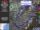
Mesoscale Discussion 1945
NWS Storm Prediction Center Norman OK
0158 PM CDT Sun Aug 18 2024

Areas affected...Central/Southern Virginia and the Carolinas

Concerning...Severe potential...Watch likely

Valid 181858Z - 182100Z

Probability of Watch Issuance...80 percent

SUMMARY...Scattered strong to severe storms are likely this
afternoon and evening.

DISCUSSION...Visible satellite trends show deepening cu across much
of the region from central/southern Virginia southward into the
Carolinas. Thunderstorm development is likely to begin in these
regions over the next 1-2 hours. A few cells have developed across
western North Carolina near the higher terrain. The air mass east of
this development is characterized by MLCAPE around 1000-2000 J/kg
with temperatures in the upper 80s-90s and dew points in the low to
mid 70s. This moist and unstable air mass will support multicell
clusters capable of downbursts. A watch will likely be needed to
cover this threat soon.

mcd1945.png
 
THE NATIONAL WEATHER SERVICE HAS ISSUED SEVERE THUNDERSTORM WATCH 635 IN EFFECT UNTIL 10 PM EDT THIS EVENING FOR THE FOLLOWING
AREAS

IN NORTH CAROLINA THIS WATCH INCLUDES 31 COUNTIES

IN CENTRAL NORTH CAROLINA

ALAMANCE ANSON CHATHAM
CUMBERLAND DAVIDSON DURHAM
EDGECOMBE FORSYTH FRANKLIN
GRANVILLE GUILFORD HALIFAX
HARNETT HOKE JOHNSTON
LEE MONTGOMERY MOORE
NASH ORANGE PERSON
RANDOLPH RICHMOND SAMPSON
SCOTLAND STANLY VANCE
WAKE WARREN WAYNE
WILSON

THIS INCLUDES THE CITIES OF ABERDEEN, ALBEMARLE, ANGIER, APEX, ARCHDALE, ASHEBORO, BUIES CREEK, BURLINGTON, CAMP MACKALL, CARRBORO, CARTHAGE, CARY, CHAPEL HILL, CLAYTON, CLINTON, CREEDMOOR, DUNN, DURHAM, ELLERBE, ENFIELD, ERWIN, FAYETTEVILLE, FRANKLINTON, GOLDSBORO, GRAHAM, GREENSBORO, HENDERSON,
HIGH POINT, HILLSBOROUGH, HOPE MILLS, KITTRELL, KNIGHTDALE, LAURINBURG, LEXINGTON, LILLINGTON, LOUISBURG, MEBANE, NASHVILLE, NORLINA, OXFORD, PINEHURST, PITTSBORO, POLKTON, PRINCEVILLE, RAEFORD, RALEIGH, ROANOKE RAPIDS, ROCKINGHAM, ROCKY MOUNT, ROSEBORO, ROUGEMONT, ROXBORO, SANFORD, SCOTLAND NECK, SELMA, SILER CITY, SMITHFIELD, SOUTHERN PINES, SPRING HOPE, SPRING LAKE, TARBORO, THOMASVILLE, TROY, WADESBORO, WAGRAM, WAKE FOREST, WARRENTON, WILSON, AND WINSTON-SALEM.
 
Couple of watches coming View attachment 150160
Interesting to see how this plays out. Some hi res models not very excited about coverage but seems those that do fire could be intense. I'm guessing scattered warnings but not a solid line situation. In fact for mby most modeling shows little to nothing
 
At 353 PM EDT, Doppler radar was tracking a strong thunderstorm near Butner, or 7 miles southwest of Creedmoor, moving northeast at 35 mph.

HAZARD... Wind gusts up to 40 mph and pea size hail.

SOURCE... Radar indicated.

IMPACT... Gusty winds could knock down tree limbs and blow around unsecured objects. Minor hail damage to vegetation is possible.

Locations impacted include...
Durham, Oxford, Creedmoor, Butner, Franklinton, Kittrell, Stem, Lake Michie, Falls Lake State Rec Area, and Gorman.
 
Will August 2cnd go down as the last day GSO hit 90? Stay Tuned. Once we cross SEP 10th,it gets highly unlikely to hit 90. Happens, but its out of the norm. We do get our fair share of Indian summer days in the 80s.
All that being said, we want be hitting 90 this week for sure. So that will leave about a 2 week window, before the blinds close.
Wet Ground , 20 inches since July4th, is paying off.
 
Severe Thunderstorm Warning
NCC101-183-182245-
/O.NEW.KRAH.SV.W.0146.240818T2206Z-240818T2245Z/

BULLETIN - IMMEDIATE BROADCAST REQUESTED
Severe Thunderstorm Warning
National Weather Service Raleigh NC
606 PM EDT Sun Aug 18 2024

The National Weather Service in Raleigh has issued a

* Severe Thunderstorm Warning for...
Southeastern Wake County in central North Carolina... Central Johnston County in central North Carolina...

* Until 645 PM EDT.

* At 606 PM EDT, a severe thunderstorm was located 8 miles east of Angier, or 14 miles west of Smithfield, moving east at 25 mph.

HAZARD... 60 mph wind gusts and quarter size hail.

SOURCE... Radar indicated.

IMPACT... Hail damage to vehicles is expected. Expect wind damage to roofs, siding, and trees.

* Locations impacted include...
Smithfield, Clayton, Micro, Selma, Wendell, Pine Level, Coats Crossroads, and Flowers.

PRECAUTIONARY/PREPAREDNESS ACTIONS...

For your protection move to an interior room on the lowest floor of a building.

&&

LAT... LON 3558 7820 3546 7824 3546 7863 3547 7865
3549 7866 3550 7868 3552 7870 3561 7871
3578 7837
TIME... MOT... LOC 2206Z 261DEG 21KT 3554 7860

HAIL THREAT... RADAR INDICATED
MAX HAIL SIZE... 1.00 IN
WIND THREAT... RADAR INDICATED
MAX WIND GUST... 60 MPH

$$

NTL
 
Back
Top