Z
Zander98al
Guest
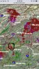
Starting to see supercell development in south MS.
"Lime Size" definitely caught my attention. How likely would that be around here?
That’s not really it. It IS frustrating when you don’t know which way to call it. When you warn family members to be ready to take cover only to have heavy rain. It’s damn frustrating. I didn’t want hail or wind but it did have that feel to it. I am relieved
No smell test needed here. I can only control what I type onto my keyboard. I cannot control how much you understand. I am sorry something is being lost in translation hereIt is hard to believe that your emotions are being dominated by “damn” frustration about there being no dangerous wx vs relief that your family is out of danger. Think about what you’re saying, man. Common sense says your reply to metwannabe doesn’t pass the smell test.
It was strange. Certainly looked like the ingredients were there. It seems we were pretty fortunate. Luckily something was missing here bc those same storms are now up around Charlotte and are Severe warnedThat storm rolled thru and produced heavy rain with lots of thunder. saw no lightning
Picked up steam as it moved east it appears. what was just rain for you was rain+thunder for me and now a severe warning further eastIt was strange. Certainly looked like the ingredients were there. It seems we were pretty fortunate. Luckily something was missing here bc those same storms are now up around Charlotte and are Severe warned


Yep this is why people don’t believe the SPC. Let’s update the map and have an enhanced risk all the way to Boone NC or Asheville NC where the threat shifted east a few hours ago according to the NWS.