B
Brick Tamland
Guest
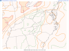
WRAL included Raleigh in the enhanced risk in their graphic, but the SPC has Raleigh just south of the enhanced risk. I know it's on the line and close enough, but seems a bit misleading for them to include Raleigh in the enhanced risk.