SimeonNC
Member
It just got really dark outside and hella windy, should I be scared?
No. It’ll be past in about 15 minutesIt just got really dark outside and hella windy, should I be scared?
Yeah, I realize that now. I was outside and was beginning to question if a warning had been issued because the storm rn looked more threatening than the ones with Fred lol.No. It’ll be past in about 15 minutes
Roughly 60 miles east of me. All by itself.


Where's your "it's happening.gif" post?95 today
Meh just didn't feel the need to advertise today lolWhere's your "it's happening.gif" post?
Nicky showed me you getting rain
You might even score a severe thunderstorm warning if u play ur cards rightMeh just didn't feel the need to advertise today lol
But it's happening
Fast forward to January, chasing winter stormsBeen noticing heat winning on models more lately
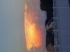
Mannnnn this thunder and lightning are legit might be the best storm of the summer imby


Hail printer tooThose are some cool mid level temps tomorrow, lightning printer gonna go brrr tomorrow View attachment 88774View attachment 88775
Love cold air aloft in the summer, can give a big boost to lightning flash rates and a big boost to anvil crawler lightning in the stratiform region/backside of storms, which I like photography wise, NAM shows -10C 500mb temps on satHail printer too


Did you see the upper low on the euro late in the run?Love cold air aloft in the summer, can give a big boost to lightning flash rates and a big boost to anvil crawler lightning in the stratiform region/backside of storms, which I like photography wise, NAM shows -10C 500mb temps on sat View attachment 88776View attachment 88777View attachment 88778View attachment 88779
Almost looks like it’s helped out by a weakness coming in from the AtlanticDid you see the upper low on the euro late in the run?
Just saw it and under it is some ?Did you see the upper low on the euro late in the run?
Graupel showers? ?Just saw it and under it is some ?
Go up 10000 feet and maybeGraupel showers? ?
It’s covering a fairly large area too .. SOIL REJOICEGreat stormy night. Agree with @SD Best night of the summer so far for storms. Lined up one right after the other.


Man take that crap away give me the dynamic energetic tropical warm core system.
I would rather have intense CG lightning and hail with a cold core vs boring rain and windMan take that crap away give me the dynamic energetic tropical warm core system.
Meanwhile..... me and Shetley, living the dusty dream!????Great stormy night. Agree with @SD Best night of the summer so far for storms. Lined up one right after the other.

This whole weather hobby is one big head fake.I think the GFS committed its first head fake of the season with that cool down / lower dews late next week..
It's gonna be a looooong season with how hard some of you weenies bit on it.
Hahahaha.

I'm more disappointed in the eps the mean was down into the low 80s but its started to warm in the extended. You had to know the 40 degree dews on the gfs might be a little aggressiveI think the GFS committed its first head fake of the season with that cool down / lower dews late next week..
It's gonna be a looooong season with how hard some of you weenies bit on it.
Hahahaha.

I'm more disappointed in the eps the mean was down into the low 80s but its started to warm in the extended. You had to know the 40 degree dews on the gfs might be a little aggressive
It was bound to happen , isn’t that a classic rule about models, they always rush the cool down .I'm more disappointed in the eps the mean was down into the low 80s but its started to warm in the extended. You had to know the 40 degree dews on the gfs might be a little aggressive