-
Hello, please take a minute to check out our awesome content, contributed by the wonderful members of our community. We hope you'll add your own thoughts and opinions by making a free account!
You are using an out of date browser. It may not display this or other websites correctly.
You should upgrade or use an alternative browser.
You should upgrade or use an alternative browser.
Tropical 94L - PTC to be issued later today
- Thread starter SD
- Start date
JHS
Member
Yeah, it was Dennis from 1999. He came far enough inland to give my area some rain.Dennis is probably the one you're remembering
The same year as Floyd which caused the whole east coast to panic
At one point Floyd was gonna hit Cape Canaveral and then it kept going up the coast
Its still moving so much faster once it gets inland than euro solution. It did slow it down some, which I think you can expect is a trend that will continue on the GFS
Moyock storm for sure.
LOL. First time I’ve heard Moyock on here. I’m in ECity.
Blue_Ridge_Escarpment
Member
Dare I say seems we are getting a consensus on the track at least.
I'd be cautious about it still. Really uncommon setup in the Atl and how Humberto evolves will play a big role. And I bet there are still a few surprises yet to come.Dare I say seems we are getting a consensus on the track at least.
lexxnchloe
Member
Remnants again come back and hit as a weak low with more rainGFS so far is much weaker and a tick slower. Humberto is a bit further south though so probably a wash
View attachment 175124
lexxnchloe
Member
You folks were correct to call me out, it was Dennis that did some wacky things in the Atlantic instead of Diane in 1999. I do remember that as
Dennis was partially responsible for one of the most unusual and productive fishing trips I've ever been on as it made its closest approach to the North Carolina coast.
Me and a friend of mine took a john boat to a pond that we fished frequently. We were using artificial lures and every cast we were getting bites. We probably caught seventy to eighty fish in about an hour. Most of them were bluegill, long ear sunfish and small bass. The fish were
jumping out of the water to grab our lures as they dangled off the side of the boat when we changed location. We easily caught over one hundred fish in about a two hour timespan. I have never seen anything to equal that.
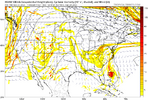
any landfalling solution probably involves shear and potential dry air entrainment with HP to the north so the board getting all worked up for a bogus TS would make sense
edit, i was wrong, the dry air actually comes from the south
View attachment 175129
halficane. i don't see imelda having a high ceiling intensity-wise
Yep, agree 100%.
Shear definitely gonna be a problem. Probably a lopsided, hybrid looking storm.
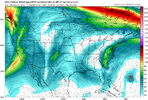
solid outflow channel here though and if it were to overperform it would be because of thatYep, agree 100%.
Shear definitely gonna be a problem. Probably a lopsided, hybrid looking storm.
View attachment 175130
Yep was just about to post that...will be moving directionally with the shear, which helps. But as you said earlier, it could be incumbered by dry air, and it absolutely will still "feel" the shear. If it develops a solid inner core quickly enough, it could keep the dry air at bay for a while, though.solid outflow channel here though and if it were to overperform it would be because of that
mx3gsr92
Member
LOL. First time I’ve heard Moyock on here. I’m in ECity.
You must have been MIA for the "Moyock Mauler" back in January. Crippling snow storm here that I told all the western guys was going to paint us white for days! 12" of powder!
Blue_Ridge_Escarpment
Member
Ground getting saturated today unfortunately ahead of this. Right at 1.5 in the gauge since midnight.
rburrel2
Member
18z Euro ai starting to cave to the gfs/euro. Has a wild stalling right along the coast solution. 20-30 inches of rain just off the coast of Wilmington.
Not to mention we don’t even really have a defined center of circulation yet. That will likely cause adjustments wherever it formsI'd be cautious about it still. Really uncommon setup in the Atl and how Humberto evolves will play a big role. And I bet there are still a few surprises yet to come.
18Z Euro: hits near NC/SC border:View attachment 175131
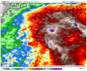
Blue_Ridge_Escarpment
Member
Eh just a run of the mill 250-300 mile shift west18z Euro ai starting to cave to the gfs/euro. Has a wild stalling right along the coast solution. 20-30 inches of rain just off the coast of Wilmington.
That was after it paralleled the coast and stalled southeast of Cape Hatteras for a week then moved west and came into Myrtle Beach as a TS. Many rivers in central and eastern NC swelled from those rains setting up the major flooding from Fran a week laterYeah, it was Dennis from 1999. He came far enough inland to give my area some rain.
I mean if its just gonna sit there it'll be slinging moisture in till the cows come home.
if you look at the last couple frames of the 18z euro you can juuuuuust start to see the HP nudging in from the north and actually see the 6-hr precip map start to beef back up as we wring out more moisture
if you look at the last couple frames of the 18z euro you can juuuuuust start to see the HP nudging in from the north and actually see the 6-hr precip map start to beef back up as we wring out more moisture
Shaggy
Member
Wonder how any dry air on the back would effect the wind field. Get some decent mixing to bring down stronger winds?
Blue_Ridge_Escarpment
Member
18Z HMON goes Georgetown, Florence, Charlotte, Hickory, Boone, Bristol
If it makes initial landfall in Moyock I’ll give him my entire retirement account! I know it’s landlocked, that’s as ridiculous as someone saying it’s their storm when there is so much variance!LOL. First time I’ve heard Moyock on here. I’m in ECity.
Per WxBell (may be different from others like TT):
Of the 18Z 30 GEFS/50 EPS members, I count ~25% that bring a lowest SLP of <1000 mb onto the E coast, but I see no lowest SLP <990 mb on the GEFS on land. There do appear to be 7 EPS members that are hurricanes/<990 mb hitting.
Avalanche
Member
You see the initial impact of Humberto and then the trough saying “enough, it’s MINE!!!”
I get what he’s implying but it still brings effects to the coast and even inland!You see the initial impact of Humberto and then the trough saying “enough, it’s MINE!!!”
It's definitely a step in our direction. It's been blowing ots for a while now. If 94L vacations in the Bahamas for a while, it'll be tough to get it in. But if it gets It's actually together ASAP, which it could, it'll run up ahead of Humberto and keep enough distance to stay NW then west.You see the initial impact of Humberto and then the trough saying “enough, it’s MINE!!!”
If it does come in with It's motor home, you better not go falling in love with it either, because it's gonna take it with it when it leaves next month.
Sent from my A600DL using Tapatalk
you know winter is coming when the Mets blow the dust off the GRAF
mx3gsr92
Member
If it makes initial landfall in Moyock I’ll give him my entire retirement account! I know it’s landlocked, that’s as ridiculous as someone saying it’s their storm when there is so much variance!
Moyock is located in Currituck County. Currituck County is bordered by the Atlantic Ocean. How much you got in that account?
NCSNOW
Member
The funnel from clockwise hp to north and counterclockwise surface low on coast, will bring its own sustained gust Noreaster styleWonder how any dry air on the back would effect the wind field. Get some decent mixing to bring down stronger winds?
Blue_Ridge_Escarpment
Member
18z euro was just enough to make quite a mess with flooding and scattered wind damage
Drizzle Snizzle
Member
Wow it’s crazy to see it go all the way into possibly Mississippi.
Shaggy
Member
18z Hwrf was also a bad run with wind and rain.18z euro was just enough to make quite a mess with flooding and scattered wind damage

