Cadi40
Member
Does that increase the threat for Charlotte? I thought the greatest threat for severe was for areas along the boundary, not south of it.
Does that increase the threat for Charlotte? I thought the greatest threat for severe was for areas along the boundary, not south of it.


Charlotte is basically ground zero for this threat imo.
So this appears to be one of the more significant threats this season for the Charlotte area?
 I can see some severe storms further north than Charlotte too. Boone, NC went from 40s to 60s. Some guidance had hinted at the severe storms for the northern mountains and SPC has Boone, NC under a Slight Risk.
Up to 70/50 which is way more than I thought we would see today as they had us socked in and barely hitting 60.
I think the forecast high here was 61.
I don’t agree with Charlotte being ground zero. If we get some supercells they are going to be west across western NC into upstate SC. Charlotte appears to be far enough East to allow these storms to merge and lose some tornado threat but could still have hail/wind.
I don’t agree with Charlotte being ground zero. If we get some supercells they are going to be west across western NC into upstate SC. Charlotte appears to be far enough East to allow these storms to merge and lose some tornado threat but could still have hail/wind.
This going to be another 3 am threat?73/58 creeping into the danger zone
Clouds quickly clearing out here in Charlotte, mostly blue skies now.
I hope not I was thinking 8-10pmThis going to be another 3 am threat?
I only follow bird guidanceThat goes against what every other guidance is saying...
Well the new SPC meso discussion says same thing that discrete storm mode is likely only at the onset. I have seen some short range models that form a bow echo before reaching Charlotte. Tough call but I think it’s premature to call Charlotte ground zero since it’s located fairly Far East if the onset is well west of Asheville NC.I only follow bird guidance
They put a low likelihood on tornadoes and very low for EF2+, idkLooking for a Tornado Watch as well.
Looking for a Tornado Watch as well.
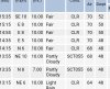
Lime sized hail, that’s a new one for me.Here are the “chances”
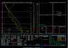
That moderate chance for 2+” hail interest me View attachment 40992
Lime sized hail, that’s a new one for me.
View attachment 40993