-
Hello, please take a minute to check out our awesome content, contributed by the wonderful members of our community. We hope you'll add your own thoughts and opinions by making a free account!
You are using an out of date browser. It may not display this or other websites correctly.
You should upgrade or use an alternative browser.
You should upgrade or use an alternative browser.
Severe 4/4-4/6 Severe Threat
- Thread starter Snowfan
- Start date
bigstick10
Member
This is the worst of the day so far, WOW.. Reed Timmer missed all of this...
At least they're stopping on the Interstate
Reposting to keep people safe and informed! Follow all tornado and severe threats live!
Ulmer cell is getting weaker on CC.
VegasEagle
Member
SnowwxAtl
Member
bigstick10
Member
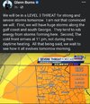
I trust the SPC more than Burns...Interesting concept!
View attachment 116845
Z
Zander98al
Guest
That's incredible
Northern Georgia is under an Enhanced risk from the SPC for tomorrow.I trust the SPC more than Burns...
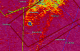
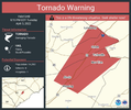
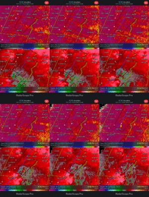
Bowman, SC Tornado now PDS warned
Clarendon, SC Supercell had a Funnel reported
Clarendon, SC Supercell had a Funnel reported
I saw a wall cloud in Beaufort SC
Z
Zander98al
Guest
whatalife
Moderator
2.5” of rain in 6 hrs. Nice.
Kidney beans galore down in the lower part of SC
I used to do a lot of telephone work in the Ulmer, allendale, Bamberg, Ehrhardt area. Lots of mobile homes. Not a heavily populated area but subject to a lot of damage.
SWVAwxfan
Member
That's way beyond insane. Let's not take shelter. Let's film it on the front porch as it rips the roof off your house.
GeorgiaGirl
Member
Insane video, but why is this guy on the front porch filming with that kind of wind (and with the roof getting damaged at least, if not ripped off).
That's what natives actually do in the Plains, sit/stand outside and watch tornadoes go by.
NoSnowATL
Member
Same reason deer don’t move out of the road when they see headlights coming towards them.Insane video, but why is this guy on the front porch filming with that kind of wind (and with the roof getting damaged at least, if not ripped off).
Stormsfury
Member
Believe this was at a Golf Course ClubhouseInsane video, but why is this guy on the front porch filming with that kind of wind (and with the roof getting damaged at least, if not ripped off).
GeorgiaGirl
Member
No severe here today, just a lot of heavy rain and thunder.
But I can see that I dodged a bullet.
Was actually able to slip outside for a walk because there was a period where it was just raining.
But I can see that I dodged a bullet.
Was actually able to slip outside for a walk because there was a period where it was just raining.
SWVAwxfan
Member
I was waiting for the words. Hey y’all, watch this.Insane video, but why is this guy on the front porch filming with that kind of wind (and with the roof getting damaged at least, if not ripped off).
bingcrosbyb
Member
One of the most insane tornado videos I’ve ever seen. And I have watched many of them.
HSVweather
Member
Z
Zander98al
Guest
SnowMan
Member
It does appear to be on the south side of town, which is mostly wooded and sparsely populated.
Damage from Wetumpka storm - Trees twisted off. Not too much structural damage.
Will post video when I can - power still out.
gawxnative
Member
Per Scanner traffic.. Pembroke area reporting 1 Fatality, 9 Injuries, "Large number missing" Search efforts still underway.
David M.
Member
I know we have all been preoccupied by today's outbreak, but has anyone seen model runs for tomorrow's setup? Beyond the possibility of storms in central GA blocking moisture for further north, I have not heard much.
Z
Zander98al
Guest
Z
Zander98al
Guest
Tbh I don't think the storms in south Georgia will effect central and north Georgias storm chances a good bit of your winds are coming from the southwest not southeast. Maybe to your immediate north destabilizion will be mest up.I know we have all been preoccupied by today's outbreak, but has anyone seen model runs for tomorrow's setup? Beyond the possibility of storms in central GA blocking moisture for further north, I have not heard much.
Also to note tornado chances are going to be way lower tomorrow than today's event. Tommorow will probably just be damaging winds and hail, very little in the way of SRH helicity. May be a spin up but that's about it
Stormsfury
Member
My friend caught this in Summerton, SC earlier. The tornadic supercell cycled and produced the Manning tornado. Another friend of mine reports that the Walmart in Manning sustained damage...
Z
Zander98al
Guest
Wondering if this is going to end up being your generational tornado outbreak for the GA/SC area, usually tornado events arent this bad around there. Of course 2021 and 2019 come to mind but for a region wide area, pretty rare occurrence for that area.

