I appreciate FFC write-up on this....Very well discussed on the potential and limiting factors but at same time each sector is borderline of being more dynamic with a few trends
Area Forecast Discussion
National Weather Service Peachtree City GA
156 PM EDT Wed Apr 6 2022
...Updated for 18Z Aviation Discussion...
.PREV DISCUSSION... /Issued 745 AM EDT Wed Apr 6 2022/
SHORT TERM /Today through Thursday/...
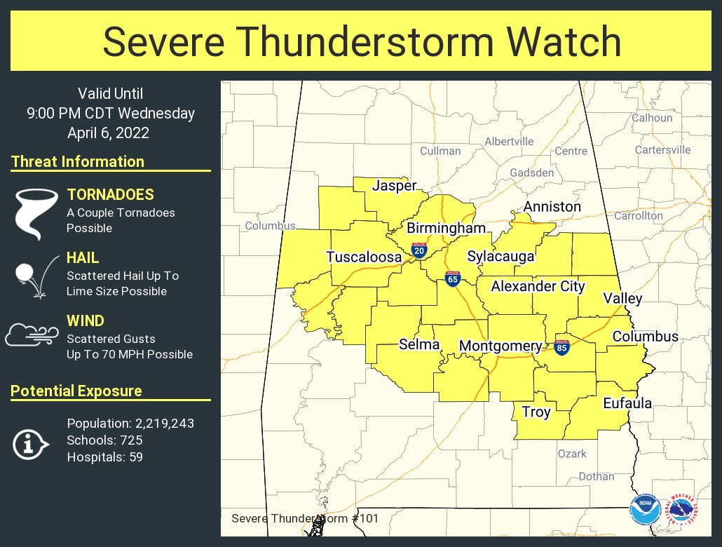
One Enhanced Risk Severe Weather
Outlook down, one more to go!
Despite a strong quasi-linear convective system sweeping through the
forecast area today, with widespread reports of wind damage and over
a dozen noted tornadic debris signatures, the area remains in a
general
warm sector regime with abundant low-level warmth and
moisture. In the mid-layers (500-700
hPA), very dry air was left
behind following the storm system, which is helping to keep
scattered light sprinkles/showers from growing more upscale,
however, by noon broad southwesterly
flow will increase
moisture in
these levels as well and boosting PWATs from near an inch in this
morning`s special 06Z
sounding to back over an inch and a half by
the afternoon for Central Georgia, setting the stage for another
potential round of severe weather.
Central Georgia, this afternoon into the early evening...
Abundant
moisture return by the afternoon in the low- to mid-levels,
is going to be timed with a northward moving coastal, baroclinic
boundary and a very weak mid-level
shortwave trough. This setup will
result in a rather abnormal setup for severe weather for this
region, but one that has worrisome combination of severe parameters:
* A weak
shortwave will provide lower-level lift across the region,
which will act as a trigger mechanism for convective development
and will cool the mid-levels between 500-700
hPa, creating lapse
rates near 7
C/km.
* With zonal-
flow in place in the mid-levels with the rapid invasion
of the
shortwave later in the afternoon, offsetting effects of
advection warmer mid-level air won`t be as present as they
otherwise would in a more classic Southeastern
SVR setup.
* Cooling in the mid-levels, combined with warm and very moist air
advecting in off the Gulf will create surface-based
CAPE values
between 2000-3000
J/kg this afternoon.
* In general, wind profiles aloft are rather weak (0-6 km
shear
values are below 30
kts) due to the weak nature of the
shortwave
likely resulting in shorter-lived, popcorn-like cells that
collapse on themselves after approx an hour with very little wind
shear between 2-6 km.
* However, in the lowest 2 km, wind
shear is decent with quarter-
circle hodographs providing good streamwise
vorticity into
developing right-moving storms and increasing the potential for
rotating thunderstorms and
spin-up circulations.
The result of all this in an environment in Central Georgia this
afternoon with no strong organizing trigger mechanism typical for a
more organized
severe thunderstorm development, although
mesoscale
boundaries or bands may change this. However, the parameters are
good for shorter-lived (1-2 hours) storms capable of large
hail and
rapidly developing short-lived tornadic circulations. This threat
followed by cooler, drier air in the mid-levels allowing evaporative
cooling which combined with water loading will present
downburst/
microburst potential as storm updrafts collapse.
Additionally, with 1-3 inches of rain previously fallen, a flooding
threat will be present anywhere heavier rain persists for prolonged
periods of time.
North Georgia, this evening into the overnight hours...
In north Georgia, a strong cold
front from a more organized
synoptic system is expected to
surge into for northwest Georgia just
before sunset. This will provide a stout triggering mechanism for
storm development, with stronger winds aloft more supportive of
longer-lived
supercell development. The
dynamics for north Georgia
during this time is everything that`s missing for Central Georgia
during the afternoon. However, despite the better
dynamics the
thermodynamics are more lacking.
* The
moisture return for north Georgia will be less abundant
resulting in PWATs just above an inch for the area,
likely
resulting in convective storms struggling to become more robust.
* Storms in the south earlier in the day may rob some surface-based
instability in the region. With that said, forecast values of
surface-based
CAPE are still expected to be above 2000
J/kg, but
begin falling after 6 PM.
* The timing of the cold
front may keep storms elevated after 8 PM,
limiting severe potential.
* With these factors in mind, low-level wind profiles are much more
favorable to tornadic supercells if they can overcome the drier
air aloft. Hodographs show sickle-
cell structures through 4-6 km,
with decent, but not perfect, storm-relative streamwise
vorticity.
* Dry air in the mid levels, could cause strong evaporative
cooling fueled downbursts in any robust storms that do form.
These winds combined with the
storm motion could create several
instances of damaging wind gusts.
All in all, please stay aware of any watches or warnings issued for
your area through the day and into tonight. Please have a plan of
action ready in case it is needed.
Following the cold
front tonight, more tranquil weather is in store
with clearing skies, breezy NW winds, and highs generally in the 60s
by Thursday.

.gif")
.gif")


 .
.


