Looks like it's riding right up US 1.I hope Raleigh can get in on the action .. we look to be right on the edge of where things get going via HRRR .. they look like some nasty cells though so radar trends will be interesting to see where things start to get going View attachment 116949
-
Hello, please take a minute to check out our awesome content, contributed by the wonderful members of our community. We hope you'll add your own thoughts and opinions by making a free account!
You are using an out of date browser. It may not display this or other websites correctly.
You should upgrade or use an alternative browser.
You should upgrade or use an alternative browser.
Severe 4/4-4/6 Severe Threat
- Thread starter Snowfan
- Start date
- Joined
- Jan 5, 2017
- Messages
- 3,794
- Reaction score
- 6,035
Surely, the greatest threats were flooding and lightning with those storms last night, for my area. It was still as a corpse. Wind was not a factor.
Clearing here. RAP/HRRR bringing over 1500 CAPE to most of central and eastern NC. SHR meh, but up toward SE VA along the warm front is looking like it has some potential later today
I was hoping it would stay cloudy and rainy all morning. I think that helped us avoid more severe storms last week.Clearing here. RAP/HRRR bringing over 1500 CAPE to most of central and eastern NC. SHR meh, but up toward SE VA along the warm front is looking like it has some potential later today
NBAcentel
Member
2 days of small hailers ? 

Here in northern GVL county in SC it wasn't much more than a rainstorm.Surely, the greatest threats were flooding and lightning with those storms last night, for my area. It was still as a corpse. Wind was not a factor.
No wind only a couple of strikes of
 & thunder.
Nothing Sevier or even borderline.
Thankful watching places to my south & west.
Downeastnc
Member
This is kinda interesting given the broken nature of the line....

Still showing that potential for a couple of decent tornados in E NC and E Va. Suns out now so let the destabilization commence

It's a good set up for our area locally to have a severe storm or 2 that has broad rotation but I think our biggest threat with long straight hodos and steepening mid layer lapse rates will be abnormally large hail for our area and maybe some downbursts. I wouldn't entirely rule out a weak brief tornado as far west as US1 but it's going to be really hard to tighten any rotation up imo.Clearing here. RAP/HRRR bringing over 1500 CAPE to most of central and eastern NC. SHR meh, but up toward SE VA along the warm front is looking like it has some potential later today
Let's see if the HRRR is even close today, if correct somewhere in NE NC/SE Va gonna get a tor warning or two

Sun is out and it's up to 76 here.
Wake must have the shields up. Showing north and south of us.Let's see if the HRRR is even close today, if correct somewhere in NE NC/SE Va gonna get a tor warning or two
View attachment 116963

She’s juicy
I’m liking the development out west too. Hoping we can pop some big hailers upon arrivalView attachment 116964
She’s juicy
Should be noted that development is all behind the cold frontI’m liking the development out west too. Hoping we can pop some big hailers upon arrival
Little more warm sector development now. HRRRRRRRR says excitement ain’t till 4-5pm at least
I get more worried about severe weather here when we've had some clearing and the sun has been out a while as opposed to what we had last week when it was raining all day. Seems that's when we have a better shot at having more widespread events, usually happening in the late afternoon and early evening. It's either then or we have it happen overnight when it's been warm for a while.Little more warm sector development now. HRRRRRRRR says excitement ain’t till 4-5pm at least

Probably the area to watch for development of cells over the next 60-90min. Little more bubbling of clouds and now some radar response in that region

That ramped up quickly
Downeastnc
Member
Feel like storms outside for the first time this season. 81 over 64....timing actually during afternoon for a change.
Is that cape of 2500 in the sandhills?
Cells developing .. now we need to start seeing lightning so we know we have strengthening updrafts
And here we go
Downeastnc
Member
And here we go
Might be a decent severe event for central and eastern NC.....
Pretty decent parameters


Might be too little too late for Raleigh specifically but out East looks primed
Although outflow interaction from storms NW with cells to our SW could be intriguingMight be too little too late for Raleigh specifically but out East looks primed
Notch, developing 60 dBz , lightning … watch 
Tornado watch just issued
HRRR says good luck @metwannabe 
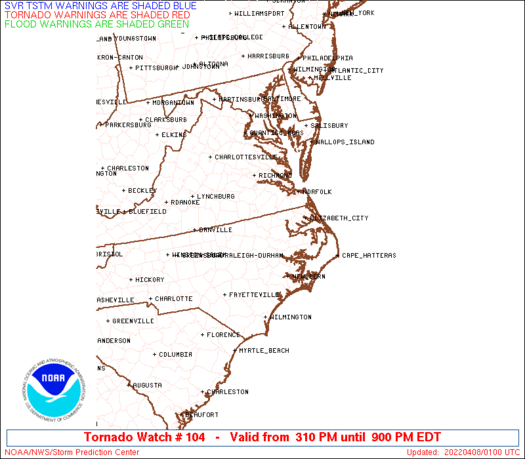
TORNADO WATCH OUTLINE UPDATE FOR WT 104
NWS STORM PREDICTION CENTER NORMAN OK
310 PM EDT THU APR 7 2022
TORNADO WATCH 104 IS IN EFFECT UNTIL 900 PM EDT FOR THE
FOLLOWING LOCATIONS
NCC013-015-029-031-041-049-053-055-061-063-065-069-073-077-079-
083-085-091-095-101-103-107-117-127-131-133-137-139-143-147-177-
181-183-185-187-191-195-080100-
/O.NEW.KWNS.TO.A.0104.220407T1910Z-220408T0100Z/
NC
. NORTH CAROLINA COUNTIES INCLUDED ARE
BEAUFORT BERTIE CAMDEN
CARTERET CHOWAN CRAVEN
CURRITUCK DARE DUPLIN
DURHAM EDGECOMBE FRANKLIN
GATES GRANVILLE GREENE
HALIFAX HARNETT HERTFORD
HYDE JOHNSTON JONES
LENOIR MARTIN NASH
NORTHAMPTON ONSLOW PAMLICO
PASQUOTANK PERQUIMANS PITT
TYRRELL VANCE WAKE
WARREN WASHINGTON WAYNE
WILSON
Torrential downpour in apex .. moving to Raleigh right now
Getting a good bit of thunder
GarnerNC
Member
Getting a good bit of thunder
Was just about to say, just started rumbling pretty good rather suddenly.
As of right now looks like I might miss the Fuquay and Angier cells to both sides of me.
Drive back and I’m paralleling this storm absolutely gorgeous .. CG lightning raging out the front edge in front of me wall of water chasing me … really putting me in a storm chasers mentality I can see why they love it .. 


Some loud thunder here in north Raleigh at my office.
Severe Weather Statement
National Weather Service Raleigh NC
339 PM EDT Thu Apr 7 2022
NCC085-101-183-072015-
/O.CON.KRAH.SV.W.0017.000000T0000Z-220407T2015Z/
Harnett NC-Wake NC-Johnston NC-
339 PM EDT Thu Apr 7 2022
...A SEVERE THUNDERSTORM WARNING REMAINS IN EFFECT UNTIL 415 PM EDT
FOR NORTHEASTERN HARNETT...SOUTH CENTRAL WAKE AND NORTHWESTERN
JOHNSTON COUNTIES...
At 338 PM EDT, a severe thunderstorm was located near Angier, or near
Lillington, moving northeast at 50 mph.
HAZARD...60 mph wind gusts and quarter size hail.
SOURCE...Radar indicated.
IMPACT...Hail damage to vehicles is expected. Expect wind damage to
roofs, siding, and trees.
Locations impacted include...
Smithfield, Lillington, Fuquay-Varina, Clayton, Angier, Coats, Four
Oaks, Coats Crossroads, Buies Creek and Raven Rock State Park.