spc has outlined a D4 outlook in western parts of the region. Farther east moisture return becomes a question


looks like a high-shear-low-cape QLCS setup for areas east of the MS River
looks like a high-shear-low-cape QLCS setup for areas east of the MS River


Fortunately severe weather tends to decrease a lot in May as it shifts further north and west.One of these days we're not going to have low-cape to save us. Especially as we warm up going into May.
Fortunately severe weather tends to decrease a lot in May as it shifts further north and west.
Fortunately severe weather tends to decrease a lot in May as it shifts further north and west.
One our biggest tornado ? outbreaks west tennessee was in May. Violent ef4 with 20 fatalities... late May when things tend to head tonthr plainsFortunately severe weather tends to decrease a lot in May as it shifts further north and west.
Yep, one of those F4's (before the EF scale) came within a few miles of my location. I can still recall standing in my front yard watching that storm go by.The biggest outbreak I can remember in the GSP CWA area took place on May 5 1989. Several EF4's that day.
Yep, one of those F4's (before the EF scale) came within a few miles of my location. I can still recall standing in my front yard watching that storm go by.
So, is this threat still viable? Seems kind of quiet here for a threat just two days out.


NAM 3km has quite a nasty QLCS with even a meso low look, lol View attachment 40546View attachment 40547
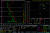
Not going to need a lot of cape with this forcing is through the roof. Really hard to see this as anything but a forced line thoughNot a lot of CAPE which is good, but I have a hard time believing the NAM as of late. It wouldn't take much to get some of that higher CAPE values up this area...
Not going to need a lot of cape with this forcing is through the roof. Really hard to see this as anything but a forced line though
Find a shelter!!So what do you do with 1000-2000 SBCAPE? Lol


Yay, another event, more backed surface winds.. View attachment 40563