What do you think for southern SC?
-
Hello, please take a minute to check out our awesome content, contributed by the wonderful members of our community. We hope you'll add your own thoughts and opinions by making a free account!
You are using an out of date browser. It may not display this or other websites correctly.
You should upgrade or use an alternative browser.
You should upgrade or use an alternative browser.
4/19/20-4/20/20 Severe Weather
- Thread starter Webberweather53
- Start date
-
- Tags
- severe weather tornadoes wind
This is definitely shaping up to be an I-20 and south event. And good 50 or so miles south, at least for the Carolina's/GA/AL. Something major would have to change for more to get into the game, not that it won't happen. But models tend to a lot better with severe wx as opposed to winter weather.
Z
Zander98al
Guest
Were in a very active weather pattern. Dont look now but two severe weather events that have some potential are forethcoming in the next 7 days excluding this sunday
NBAcentel
Member
This is definitely shaping up to be an I-20 and south event. And good 50 or so miles south, at least for the Carolina's/GA/AL. Something major would have to change for more to get into the game, not that it won't happen. But models tend to a lot better with severe wx as opposed to winter weather.
Yeah looks like NC will get elevated convection from SW warm/moist advection aloft towards the mid levels but a stable layer around the planetary boundary layer, great lightning photography chance for me without having to worry about damaging winds
Yeah looks like NC will get elevated convection from SW warm/moist advection aloft towards the mid levels but a stable layer around the planetary boundary layer, great lightning photography chance for me without having to worry about damaging winds
I am good with that! Love elevated storms, thunder is twice as loud and we don't have to worry about tornadoes and damaging winds, like last week!
NBAcentel
Member
I am good with that! Love elevated storms, thunder is twice as loud and we don't have to worry about tornadoes and damaging winds, like last week!
Hmmm the NAM3km made things more interesting however, advects so much MUcape that hail would start to become a issue, SRWs are favorable for hail aswell


Attachments
Hmmm the NAM3km made things more interesting however, advects so much MUcape that hail would start to become a issue, SRWs are favorable for hail aswell View attachment 39691View attachment 39692View attachment 39689View attachment 39690
Ugh, of course, it did! I don't like the look of those storms.
NBAcentel
Member
Ugh, of course, it did! I don't like the look of those storms.
At least the tornado/damaging wind threat would be hindered significantly by the stable layer/weak llvl lapse rates, but hail can definitely be a issue with elevated storms, It’s definitely close tho
At least the tornado/damaging wind threat would be hindered significantly by the stable layer/weak llvl lapse rates, but hail can definitely be a issue with elevated storms, It’s definitely close tho
My only worry is being in the Southern Piedmont. We seem to somehow come into play at the very last minute, aka now. Not that I see a widespread tornado/damaging wind outbreak, but if this warm front makes it's way up here, we could have some issues. Remember The Upstate was in a wedge all day on Sunday and still managed to see some significant tornadoes. Not that the setup is close, but it makes you think. Everyone thought that The Upstate would be fine due to the wedge, but that wasn't the case.
mbway091
Member
My only worry is being in the Southern Piedmont. We seem to somehow come into play at the very last minute, aka now. Not that I see a widespread tornado/damaging wind outbreak, but if this warm front makes it's way up here, we could have some issues. Remember The Upstate was in a wedge all day on Sunday and still managed to see some significant tornadoes. Not that the setup is close, but it makes you think. Everyone thought that The Upstate would be fine due to the wedge, but that wasn't the case.
Last week models were showing serious issues for the entirety of the Piedmont from pretty much day one I think.
Last week models were showing serious issues for the entirety of the Piedmont from pretty much day one I think.
Yes, they were. But things do change. I don't think models will resort to last week's soundings. Not that I am an expert, we are just too close for things to change that much. But hey, I could be wrong.

Z
Zander98al
Guest
Was looking at 18z nam 3km and it shows a MCS causing that. If future radar is correct itll create a pesky tornado threat. As these spin ups come and go in lines like that.
NBAcentel
Member
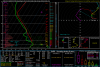
NAM is creeping north with STP 

This is concerning. The 3km NAM was on the lower side of UH the last event. Possibly very dangerous situation unfolding on the warm front/triple point. This is close to the same situation that hit Lee county last year.

accu35
Member
Your the "Meteorologist " you tell usWhat do you think for southern SC?
mydoortotheworld
Member
Haven't kept up with this system but from the looks of it... this is trending northward... didn't think ATL would see anythingThis is concerning. The 3km NAM was on the lower side of UH the last event. Possibly very dangerous situation unfolding on the warm front/triple point. This is close to the same situation that hit Lee county last year.
Jrips2710
Member
3K NAM verbatim doesn't get the ATL metro above 60 all day Sunday or overnight. That's not to say the threat would be eliminated but I would think cool temps would dampen the significant severe threat pretty good.Haven't kept up with this system but from the looks of it... this is trending northward... didn't think ATL would see anything
Might be a pretty crazy gradient along that warm front. This is right before the main activity starts Sunday night

The WRFs are less impressive than the NAM, although they are more impressive instability wise. The main limiting factors being storm mode and low level helicity.
BufordWX
Member
If anything our biggest threat would probably be heavy rain and isolated flooding issues.3K NAM verbatim doesn't get the ATL metro above 60 all day Sunday or overnight. That's not to say the threat would be eliminated but I would think cool temps would dampen the significant severe threat pretty good.
Might be a pretty crazy gradient along that warm front. This is right before the main activity starts Sunday night View attachment 39702
Jrips2710
Member
Agreed. Don't think it's impossible to shift the warm front north 60-80 miles over the next 48 hours but as of right now would say the main severe threat is south of Atlanta.If anything our biggest threat would probably be heavy rain and isolated flooding issues.
Monster hail sounding around Clanton, AL on the 3km NAM. You don't see this type of instability in AL.

Your the "Meteorologist " you tell us
It's not time be a jackhole, I just asked because I know plenty people on this forum with a lot of meteorology experience. Btw I am an aspiring Meteorologist so have a seat @accu35 and learn to mind your business because I KNOW you did not know the answer to my question.
Webberweather53
Meteorologist
Definitely doubtful we’ll have enough legit non zero cape here in Charlotte, significant cold air damming develops out in front of the main surge before the warm sector gets here and is probably reinforced by diabatic heating from all the convection that’ll be overheadNAM is creeping north with STP View attachment 39700View attachment 39701
NBAcentel
Member
Definitely doubtful we’ll have enough legit non zero cape here in Charlotte, significant cold air damming develops out in front of the main surge before the warm sector gets here and is probably reinforced by diabatic heating from all the convection that’ll be overhead
Yeah, it’s close for areas near Columbia SC, we’ll probably just get the elevated stuff from how stable the PBL will be, I don’t mind a break because next week looks active
@Webberweather53 what you think for us here in Southern SC?Definitely doubtful we’ll have enough legit non zero cape here in Charlotte, significant cold air damming develops out in front of the main surge before the warm sector gets here and is probably reinforced by diabatic heating from all the convection that’ll be overhead
If the 3KM NAM is close to right, Southern SC is looking at another possible round of tornadoes and wind damage.
Keywords: "if" and "nam"
With that said, it's not far from the Midlands, either. There's a few limiting factors, but overall we'll probably be seeing storms sweep across the state again.
Also to the earlier question about the Euro being slower (i haven't looked tonight), it was too slow last event too.
Also, for the SC questions, this looks pretty good right now with the Enhanced area.. but as we get closer we are gonna have to watch just how far North that warm front gets for more inclusion of the Midlands, along with how much junk convection/rain is out there.

Jrips2710
Member
3K NAM has 80 in Macon and 57 near Griffin Sunday evening. Good luck figuring this out 

Haven't kept up with this system but from the looks of it... this is trending northward... didn't think ATL would see anything
Only the NAM is trending northward. The GFS / GGEM seemed to have shifted southward.
BTW, that temperature gradient on the NAM gives me hives.
The latest GFS has shifted a bit North versus previous less of a push i guess coming out of that canadian low, but im on small resolution currently to be looking @ this stuff.
NoSnowJoe
Member

Keeps edging north closer to the Atlanta area.
Recent NAM is much more bullish on instability reaching north of BHM with a very clean warm sector. Low level helicity higher as well with lots of PDS soundings across central AL with surface cape in excess of 3000 and the supercell composite hitting 30. Wouldn’t be surprised to see a moderate risk issued across central AL and MS.
This is 6z 3km NAM, 12z coming out right now. Definitely don't take it as gospel because the 3km NAM is goofy and shouldn't be trusted. The flip side is it has been a good bit too weak on UH the past few events.

Z
Zander98al
Guest
Oof. You sound more concernced about this setup than the last. Whats the differences between last events and this one?Recent NAM is much more bullish on instability reaching north of BHM with a very clean warm sector. Low level helicity higher as well with lots of PDS soundings across central AL with surface cape in excess of 3000 and the supercell composite hitting 30. Wouldn’t be surprised to see a moderate risk issued across central AL and MS.
Really have 2 or 3 distinct hazards tomorrow. Storms that can get going just ahead of the sfc low along the tmb may get a boost from locally backed wind, more classic supercells in Southern Al and South Ga then a potential organized qlcs/spin up event on the northern fringeThis is 6z 3km NAM, 12z coming out right now. Definitely don't take it as gospel because the 3km NAM is goofy and shouldn't be trusted. The flip side is it has been a good bit too weak on UH the past few events.
Oof. You sound more concernced about this setup than the last. Whats the differences between last events and this one?
Much better discrete forcing and wind vectors, much better lapse rates, much better 0-3km cape. This checks ALL the boxes historically for AL bad tornado days. Of course it also checks the boxes for how they bust. But this sounding is textbook and will still be getting better in the hour or two past this sounding.

I agree...NAM showing CAPE over 2k here. I wouldn't be surprised to see a MDT from central MS to central GA. In fact, around here we are probably going to have extra low level helicity because of the warm front hanging around.Recent NAM is much more bullish on instability reaching north of BHM with a very clean warm sector. Low level helicity higher as well with lots of PDS soundings across central AL with surface cape in excess of 3000 and the supercell composite hitting 30. Wouldn’t be surprised to see a moderate risk issued across central AL and MS.
Just noticed this sounding is flagging 4/16/98 like the Ukmet did earlier this week.