Glenn Burns saying Carroll and Heard may see a tornado soon . No tonardo watch yet
The National Weather Service is your best source for complete weather forecast and weather related information on the web!

forecast.weather.gov
Severe Weather Statement
National Weather Service Peachtree City GA
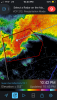
1157 PM EDT Thu Mar 25 2021
GAC077-260415-
/O.CON.KFFC.TO.W.0014.000000T0000Z-210326T0415Z/
Coweta GA-
1157 PM EDT Thu Mar 25 2021
...A TORNADO WARNING REMAINS IN EFFECT UNTIL 1215 AM EDT FOR
NORTHWESTERN COWETA COUNTY...
At 1157 PM EDT, a confirmed large and extremely dangerous tornado was
located near Powers Crossroads, or 8 miles southwest of Newnan,
moving east at 45 mph.
This is a PARTICULARLY DANGEROUS SITUATION. TAKE COVER NOW!
HAZARD...Damaging tornado.
SOURCE...Radar confirmed tornado.
IMPACT...You are in a life-threatening situation. Flying debris may
be deadly to those caught without shelter. Mobile homes
will be destroyed. Considerable damage to homes,
businesses, and vehicles is likely and complete destruction
is possible.
Locations impacted include...
Newnan, Moreland, East Newnan, Arnco-Sargent, Powers Crossroads,
Handy and Madras.
PRECAUTIONARY/PREPAREDNESS ACTIONS...
To repeat, a large, extremely dangerous and potentially deadly
tornado is on the ground. To protect your life, TAKE COVER NOW! Move
to a basement or an interior room on the lowest floor of a sturdy
building. Avoid windows. If you are outdoors, in a mobile home, or in
a vehicle, move to the closest substantial shelter and protect
yourself from flying debris.
Tornadoes are extremely difficult to see and confirm at night. Do not
wait to see or hear the tornado. TAKE COVER NOW!
&&
LAT...LON 3349 8476 3339 8467 3329 8469 3328 8496
3333 8498 3342 8500
TIME...MOT...LOC 0357Z 260DEG 39KT 3332 8493
TORNADO...OBSERVED
TORNADO DAMAGE THREAT...CONSIDERABLE
HAIL...1.50IN
$$