• Hello, please take a minute to check out our awesome content, contributed by the wonderful members of our community. We hope you'll add your own thoughts and opinions by making a free account!

Tropical 2025 Tropical Thread

LC

Now we must watch the ITCZ waves in Africa, as conditions upstream (lighter winds, more upper ridging, water warmers) are looking favorable for tropical cyclone development. The large impulse west of the Cape Verde Islands is riddled with dry air and dust. But note that convective circulation in Niger and Nigeria (and the two others approaching from the Nile Headwaters and the Horn Of Africa). Riding underneath a broad subtropical high, chances for a named storm are increasing near the Lesser Antilles in about ten days. The Saharan and Kalahari ridge complex keep the northern and southern African nations hot and dry (with the exception of a cold frontal passage in the vicinity of Gqeberha and Durban).
What are your personal thoughts on hurricane season? We know you can copy and paste from X. Just wanting some insight to your forecasts?
 
What are your personal thoughts on hurricane season? We know you can copy and paste from X. Just wanting some insight to your forecasts?
I agree with LC's latest. He sticks with 22/12/6


In regard to tropical threats, note that the dry/dusty air may get in the way of the first ITCZ impulse in the equatorial Atlantic Ocean. But there are many more disturbances on the way, plus weaknesses moving below the sprawling ridge complex. The CFS solution hints at a Texas strike, and remember that version was the only one to point out the rain and cooling scenario for central Texas last month. The sea surface temperatures are rather warm, while at the same time those in the equatorial Pacific Basin are slowly cooling. A weak/moderate La Nina should be called by October 1. There is nothing in the 500MB longwave pattern, or the erratic, non-linked Madden-Julian Oscillation, that would create a shearing influence in the upper air or allow the Saharan Air Layer to run amok and squelch warm-core cyclogenesis. In short, we may see the major islands and/or U.S. involved in a named storm path soon. I will stick with my call for 22 named storms, 12 hurricanes, and 6 major cyclones.

It is going to be hot, and stormy, for the remainder of the summer and the first part of autumn.
 
Seen on Facebook for this upcoming week. The yellow circle View attachment 173472

The ICON has at least been hinting at this since the Wednesday (7/9) runs whereas the other recent operationals have not had too much, if anything. Ensemble support is only light.

If this does occur, it would be an easy win for the Icon.
 
prateptype_cat-imp.conus.png
The GFS does show this low that moves westward off the Florida peninsula into the Gulf but nothing becomes of it. The ICON shows development into possibly a tropical storm. The Gulf is the one area to watch for tropical development until the shear lessens up over the Atlantic later in the month.
 
Last edited:
I know there are other factors, but I've never worried too much about tropical activity in NC/SC as long as the Bermuda High is slightly further west than usual. When it shifts east or we get a high off the NE coast that can push something west along our latitude that's when I start paying attention.
 
ICON going nuts with the Gulf system .
CjjNpO2.png
 
Recon possible this Tuesday.
WEATHER RECONNAISSANCE FLIGHTS
CARCAH, NATIONAL HURRICANE CENTER, MIAMI, FL.
1000 AM EDT SUN 13 JULY 2025
SUBJECT: TROPICAL CYCLONE PLAN OF THE DAY (TCPOD)
VALID 14/1100Z TO 15/1100Z JULY 2025
TCPOD NUMBER.....25-043

I. ATLANTIC REQUIREMENTS
1. NEGATIVE RECONNAISSANCE REQUIREMENTS.
2. OUTLOOK FOR SUCCEEDING DAY: POSSIBLE LOW-LEVEL INVEST MISSION
OFF THE FLORIDA GULF COAST NEAR 26.5N 82.5W FOR 15/1800Z.
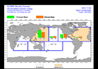


So far for late July through Aug 10th, the Euro Weeklies have remained pretty quiet in the ATL basin with it much more active in the PAC basins (climo of 2005-2024 in orange boxes). This contrast is easy to see when comparing the size of the green boxes. Of course, it remains to be seen how well or not these forecasts actually verify:

July 28th-Aug 3rd:
IMG_4006.png

Aug 4th-10th:
IMG_4005.png
 
The main models and ensembles from the 12z suite have absolutely nothing of note in the Gulf this week. I can imagine that a weak low may develop, but I really don't see much in the way of a legitimate tropical threat out of this. May see enhanced precipitation in FL to the Gulf coast and inland around LA/MS.

Edited to fix numerous 3rd grade spelling and grammar errors sheesh.
 
Last edited:
The main models and ensembles fr9m the 12z suite have absolutely nothing of note in the Gulf this week. I can image that a weak low may develop, but I really don't see much in the way of a legitimate tropical threat out of this. May see enhanced precipitation in FL to the Gulf coast and inland around LA/MS.
People can post all.sorts of Twitter posts about shear or good conditions and I'll sit back and watch the ensembles. They are the best indicators to real world storms
 
People can post all.sorts of Twitter posts about shear or good conditions and I'll sit back and watch the ensembles. They are the best indicators to real world storms
Yeah for sure. The 6z EPS at least had a little action. In fact, one member had a strong system. 12z looks bleak.
 
The NWS is giving that area of disturbed weather/weak low that will move into the Gulf a 20% chance of development over the next seven days. As of now it looks like things will remain quiet in the Atlantic basin.
 
More hurricanes later in summer through mid fall. Follow me on X for my fall and winter forecast, hint, it gets colder
Been patiently waiting on your breakthrough cane forecast. Now I can populate my August-October calendar. Thanks, pal! 🍻
 
000
NOUS42 KNHC 141410
REPRPD
WEATHER RECONNAISSANCE FLIGHTS
CARCAH, NATIONAL HURRICANE CENTER, MIAMI, FL.
1010 AM EDT MON 14 JULY 2025
SUBJECT: TROPICAL CYCLONE PLAN OF THE DAY (TCPOD)
VALID 15/1100Z TO 16/1100Z JULY 2025
TCPOD NUMBER.....25-044

I. ATLANTIC REQUIREMENTS
1. SUSPECT AREA (EAST OF FLORIDA)
FLIGHT ONE - TEAL 71
A. 15/1800Z
B. AFXXX 01DDA INVEST
C. 15/1600Z
D. 30.0N 80.0W
E. 15/1730Z TO 15/2200Z
F. SFC TO 10,000 FT
G. LOW LEVEL INVEST
H. WRA ACTIVATION


2. OUTLOOK FOR SUCCEEDING DAY: POSSIBLE MISSION INTO SUSPECT
AREA OFF THE FLORIDA PANHANDLE NEAR 29.0N 86.0W FOR 16/1800Z.

II. PACIFIC REQUIREMENTS
1. NEGATIVE RECONNAISSANCE REQUIREMENTS.
2. OUTLOOK FOR SUCCEEDING DAY.....NEGATIVE.

$$
WJM

NNNN
recon tommorow.
 
THC still hasn't bought into the disturbance that will move into the northern Gulf giving it only a 30% chance of development within seven days. Satellite imagery does seem to indicate it is getting more organized however and more of the models are showing something tropical in their forecasts. I expect the odds of this developing are going to increase as time goes by. Folks in Texas do not need another big rain maker in their forecast.
 
Last edited:
Back
Top