• Hello, please take a minute to check out our awesome content, contributed by the wonderful members of our community. We hope you'll add your own thoughts and opinions by making a free account!

Tropical 2024 Tropical Thread

Status
Not open for further replies.
From Larry Cosgrove


Careful review of the Atlantic Basin and Africa shows an impressive Saharan heat ridge complex. There are still low latitude westerlies aloft, so even with a strong pulse ITCZ at work through the equatorial regions, we are not likely to see any meaningful tropical cyclones for the next two months. It is either shear or the vast amount of sand and hot/dry air that will diminish these systems. But when the subtropical high begins to parcel and shift toward the Mediterranean Sea, the cTw air mass will suspend and there will be less infiltration on impulses as each passes Cape Verde into the Atlantic Ocean. This will be a very active and probably dangerous hurricane season with impacts on the major islands, USA, and Canada. But I think that the main action waits until gaps in the ridge appear in Mid-August. Once here, the action will probably continue until just after Halloween. The numbers: 18 named storms, 10 hurricanes, 6 major cyclones, with strike probabilities for both Gulf and Atlantic coasts. The equatorial Pacific theater could see 11 named storms, 7 hurricanes, and 3 major events.
 
It appears to me that the new runs (12Z GFS and CMC) are developing what is already just offshore Africa. They both have a TS in the Windward Islands on Mon July 1st.

Edit: The 12Z UKMET has nothing classified as a TC through the end of the run (day 7).

Edit: 1. The 12Z GEFS/GEPS have a rather strong signal for a TC impacting the Lesser Antilles ~7/1-3.

2. The 12Z Euro has no TC unlike the prior two runs.

3. But the 12Z EPS is the most active run yet for this.
 
Last edited:
The TW in the SE Caribbean has recently been designated Invest 94L. Central America could be impacted if this were to develop. Highly doubtful the US would be impacted heavily except for perhaps S TX the way it looks now. But things can change quite a bit this far out.
 
For wave in E Atlantic, main 0Z Models excluding Euro:

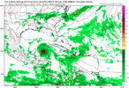
-GFS is by far its strongest run yet as it has a 975-7 mb H hitting the Windward Islands on July 1st, which then weakens and later dissipates in the Caribbean

-CMC just has a weak low vs 12Z’s TS

-ICON just has a weak low similar to 12Z

-UKMET doesn’t have a TC just like the 12Z

-GEFS is about as active as the 18Z. These last two runs are the strongest runs yet at the Lesser Antilles July 1-2
 
12Z runs for TW SW of CV Islands:

-GFS/CMC TS+ Lesser Antilles ~7/1; so CMC stronger than 0Z and similar to yesterday’s 12Z

-ICON stronger low than 0Z/borderline TD?

-UKMET still no TC through 168

-GEFS still rather active

Up to 40% now:
Eastern Tropical Atlantic:
A tropical wave located a few hundred miles southwest of the
Cabo Verde Islands is producing disorganized showers and
thunderstorms. Some development is possible during the next several
days, and a tropical depression could form over the tropical
Atlantic by the end of the week or this weekend while the system
moves westward at 15 to 20 mph.
* Formation chance through 48 hours...low...near 10 percent.
* Formation chance through 7 days...medium...40 percent.
 
Last edited:
12Z Euro is much stronger as it has a TS on 7/1 in the Lesser Antilles and a hurricane later on in the Caribbean!

I’m pretty sure we’ll need a separate thread for this soon.
 
12Z Euro is much stronger as it has a TS on 7/1 in the Lesser Antilles and a hurricane later on in the Caribbean!

I’m pretty sure we’ll need a separate thread for this soon.
Looks like at least a TS since the GFS and Euro agree. But will it just wash out like the GFS shows?
 
12Z Euro ensemble is its most active run yet at Lesser Antilles ~July 1st
 
TW SW of CV:
After Lesser Antilles 12Z Euro ensemble tracks most concentrated toward Cuba to Nicaragua corridor followed by good number hitting MX/TX/W LA while minority threaten PR to SE US with only very few recurving offshore the E US coast
 
TW SW of CV islands is now Invest 95L:


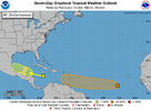
Eastern Tropical Atlantic (AL95):
Satellite images indicate that a tropical wave located several
hundred miles southwest of the Cabo Verde Islands has become better
organized since yesterday with a more concentrated area of
thunderstorms. Environmental conditions are forecast to be
unusually conducive for late June across the central and western
tropical Atlantic, and further development of this system is
anticipated.
A tropical depression or tropical storm could form
this weekend several hundred miles east of the Windward Islands
while the system moves westward at 15 to 20 mph.
* Formation chance through 48 hours...low...30 percent.
* Formation chance through 7 days...medium...60 percent.two_atl_7d0 (19).png
 
Some of these GFS runs for 95L would be almost unheard of this early. If this becomes a hurricane before the Caribbean there are no real analogs recently
 
Status
Not open for further replies.
Back
Top