Not when they're calling for it. They always hype up a level .5 risk for general thunderstorms and it never does anything here. It only rains when they predict sunny skies and moonrays.
-
Hello, please take a minute to check out our awesome content, contributed by the wonderful members of our community. We hope you'll add your own thoughts and opinions by making a free account!
You are using an out of date browser. It may not display this or other websites correctly.
You should upgrade or use an alternative browser.
You should upgrade or use an alternative browser.
Severe 2024 Severe Discussion
- Thread starter RBR71
- Start date
Shaggy
Member
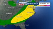
I was under marginal risk and it was a marginally bad storm lol.Not when they're calling for it. They always hype up a level .5 risk for general thunderstorms and it never does anything here. It only rains when they predict sunny skies and moonrays.
No storm tonight.
Brent
Member
Yes, AL and MO seemed to be ground zero for tornadoes the past decade or so. Been a long while since tornado Alley has seen action like this.Remember when tornado alley was shifting east? Already more tornadoes in Oklahoma this year than any year this decade and the HRRR looks like a high risk tomorrow View attachment 147854
Brent
Member
The storms on simulated radar look insane , even into your area! Stay safe! Nighttime severe sucksHere we go again View attachment 147855
Downeastnc
Member
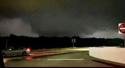
Reed got a decent one on his feed
Downeastnc
Member
Big stovepipe
Downeastnc
Member
Downeastnc
Member
Downeastnc
Member
TOG moving through Claremore....chaser live streaming in it looks bad...
Last edited:
Downeastnc
Member
Downeastnc
Member
Downeastnc
Member
Downeastnc
Member
Brent
Member
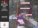
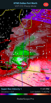
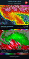
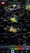
This couplet about to cross unto a pretty populated lake area north of Dallas. Lots of RV parks and campgrounds...
View attachment 147856

Brent
Member
Downeastnc
Member
Still ongoing this morning there were a lot of strong tornados overnight last night with numerous tracking through populated areas. This is same cell that produced the Claremore tornado apparently.
Last edited:
Downeastnc
Member
There are fatalities, got to wonder how many campers ended up in the lake, really it will be a great surprise if only 5 died last night
Downeastnc
Member
NWMSGuy
Member
Brent
Member
Cooke County Sheriff Ray Sappington confirmed five fatalities and 20 injuries in Saturday night's storm. Sappington said an AP Travel Center-Shell station on Lone Oak Road off Interstate 35 south of Valley View was hit very hard as well as Frf Estates area, a mobile home and RV park neighborhood west of the gas station.
Downeastnc
Member
This is what the HRRR does with the line in Missouri currently....
Brent
Member
Northeast of here
Two people are dead and several are injured after severe weather swept through the state on Saturday night, Mayes County officials confirmed.
Two people are dead and several are injured after severe weather swept through the state on Saturday night, Mayes County officials confirmed.
Brent
Member
Brent
Member
10 dead over 3 states now 2 children found dead in Texas with the biggest tornado
1 in Arkansas
1 in Arkansas
Nadocast was never onboard with yesterdays threat but it sure loves today lol
Nadocast was never onboard with yesterdays threat but it sure loves today lol
Wow, over 50% chance for portions of KY and TN. Hope it calms down before the severe threat moves east towards here tomorrow.
Brent
Member
Video inside the gas station hit in Texas 
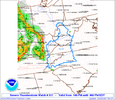
Storm Prediction Center PDS Tornado Watch 320
Severe weather, tornado, thunderstorm, fire weather, storm report, tornado watch, severe thunderstorm watch, mesoscale discussion, convective outlook products from the Storm Prediction Center.
www.spc.noaa.gov
Downeastnc
Member
So my wifes cousins live in just north of Sanger TX and took a hit last night, they are fine and the house is intact with minor roof issues, but all their vehicle were totaled and the horse barn was leveled, not sure about the status of the horses.
I hope the horses are okay. I'm glad they are okay.So my wifes cousins live in just north of Sanger TX and took a hit last night, they are fine and the house is intact with minor roof issues, but all their vehicle were totaled and the horse barn was leveled, not sure about the status of the horses.
Downeastnc
Member
Tornado in St Louis metro
GeorgiaGirl
Member
Just saw a shot of how the weather looks like around the field for the STL baseball team, it's pretty nasty out there.
Snow_chaser
Member
Brandon Copic has a big tornado right now in Missouri


