Shaggy
Member
Looking at the drone footage it doesn't look like it was extremely wide and spared a much bigger disaster than if it was a 1/4 mile wideThey are still not releasing death toll on local TV as of noon today.
Looking at the drone footage it doesn't look like it was extremely wide and spared a much bigger disaster than if it was a 1/4 mile wideThey are still not releasing death toll on local TV as of noon today.
Ain't no way that's EF3 only. It's pretty clear EF 4 seems likely the final classificationGreenfield rated EF-3
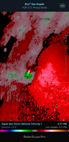
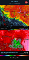
Hopefully it stays north of my location. Wanting to head to the lake that day.sunday afternoon frame, about memphis tn to around southern illinois vinicinty,about as vilotile of a atmosphere you can get be honest. then you throw in spring time dynamics with it.... better hope mid level cap can hold firm,
Hopefully it stays north of my location. Wanting to head to the lake that day.
Hopefully it stays north of my location. Wanting to head to the lake that day.
if latest guidance is correct, i can see northern miss getting a least enhanced risk before this weeks out models r just about Sicking ... atmosphere is loadedHopefully it stays north of my location. Wanting to head to the lake that day.
That’s prelim as of todayAin't no way that's EF3 only. It's pretty clear EF 4 seems likely the final classification
So how do they factor in DOW data or do they even use it?
It would be like seeing a strong hurricane and only classifying it a cat 1 because recon can't reach it.I get why it is the way it is but if a EF5 does not hit a structure that is strong enough to warrant a EF5 rating then it can never be a EF5 even though it is is kind of dumb if you have other solid data that shows that it is most likely EF5.
Agree 100%. It’s definitely a problem with the system and I’m not sure what the fix is to keep it all fair.I get why it is the way it is but if a EF5 does not hit a structure that is strong enough to warrant a EF5 rating then it can never be a EF5 even though it is is kind of dumb if you have other solid data that shows that it is most likely EF5.
Agree 100%. It’s definitely a problem with the system and I’m not sure what the fix is to keep it all fair.
I saw this as well which I thought was interesting
Good call. Apologies for not seeing that yesterdayIf you go back and read yesterday's post I referenced the Andover tornado as a comparison. It was a carbon copy

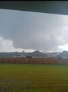
Somebody mentioned this earlier in here I believe!View attachment 147824