NoSnowATL
Member
And its dead.

Gfs op has been showing a mischief past few runsThe op is quiet for the gfs but it's ensembles have a few things of interest floating around


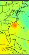
Watch out if anything moves right there. Water temps there in the low to mid 90s.

Sent from my iPhone using Tapatalk
Nice position to go boom!
Sent from my iPhone using Tapatalk


NopeMore hints at the Atlantic waking up, let’s see if it can hold longer then 1 model run.

 forecast.weather.gov

Nino's suck for African storms. They get sheared and shredded. Only homegrown storms this year it appears.This aint the year/season for the tropics. Next year 2024 will be a different story. Course all it takes is one to whip up at the right time,place.
I think you’re correct here. Too much shear is already setting up for those waves. I would watch the western Caribbean as we get further into August and September.Nino's suck for African storms. They get sheared and shredded. Only homegrown storms this year it appears.

Classic CAD!Poop
Nino's suck for African storms. They get sheared and shredded. Only homegrown storms this year it appears.
Since this El Niño appears to be trending stronger, I went and looked at both the 1997 and 2015 seasons. Both of these were in the start of very strong Niños and all the storms to impact the US mainland those years were homegrown. Also they don’t necessarily have to hit the mainland to have a big impact. Joaquin in 2015 moved well east of the southeast coast after developing in the western Caribbean and moving over Cuba… however a low in the strong STJ was able to tap into Joaquin’s moisture a produce major flooding for much of the central and eastern Carolinas.Most of the African storms recurve anyway... I mean yeah every now and then one gets through but the list that don't is longer. We just remember the ones that did...
Always want to watch homegrown more

Best joke I've heard In agesMaybe once the GFS will be right.
LolMaybe once the GFS will be right.
Feels like a "homegrown" late season, maybe October, special type of yearI don't think conditions for tropical development will be favorable for the next ten days or so in the Atlantic. There is a lot of dust and dry air from the Sahara flying around and a strong trough is forecast to set up shop off the Northeast US feeding strong wind shear throughout the Atlantic and Caribbean. Once that trough relaxes and the dry air flow weakens, the bath water in the Atlantic and Gulf of Mexico will add plenty of fuel for something strong to develop.

 www.tropicaltidbits.com
Feels like a "homegrown" late season, maybe October, special type of year
Wpac overperforming again. This was suppose to top out at 85kts but now is cat 3 with a beautiful stadium effect
Visible Satellite Loop for Himawari-9 Meso Sector | Tropical Tidbits
Himawari-9 Meso Sector Visible Satellite Loop