Season of the Curveballs. Im expecting a lot of curves/fish storms. Looks like one might be forming over the eastern Atlantic right now


Central Atlantic (AL94):
An area of low pressure located more than 700 miles east of Bermuda
continues to produce disorganized showers and thunderstorms
primarily to the southeast of its center. Environmental conditions
are forecast to be marginally conducive for this system to become a
subtropical depression or storm during the next couple of days while
it meanders over the central Atlantic. By the weekend, the low
should turn northward bringing the system over cooler waters,
potentially limiting additional development. Additional information
on this system, including gale warnings, can be found in High Seas
Forecasts, issued by the National Weather Service.
* Formation chance through 48 hours...medium...60 percent.
* Formation chance through 7 days...medium...60 percent.

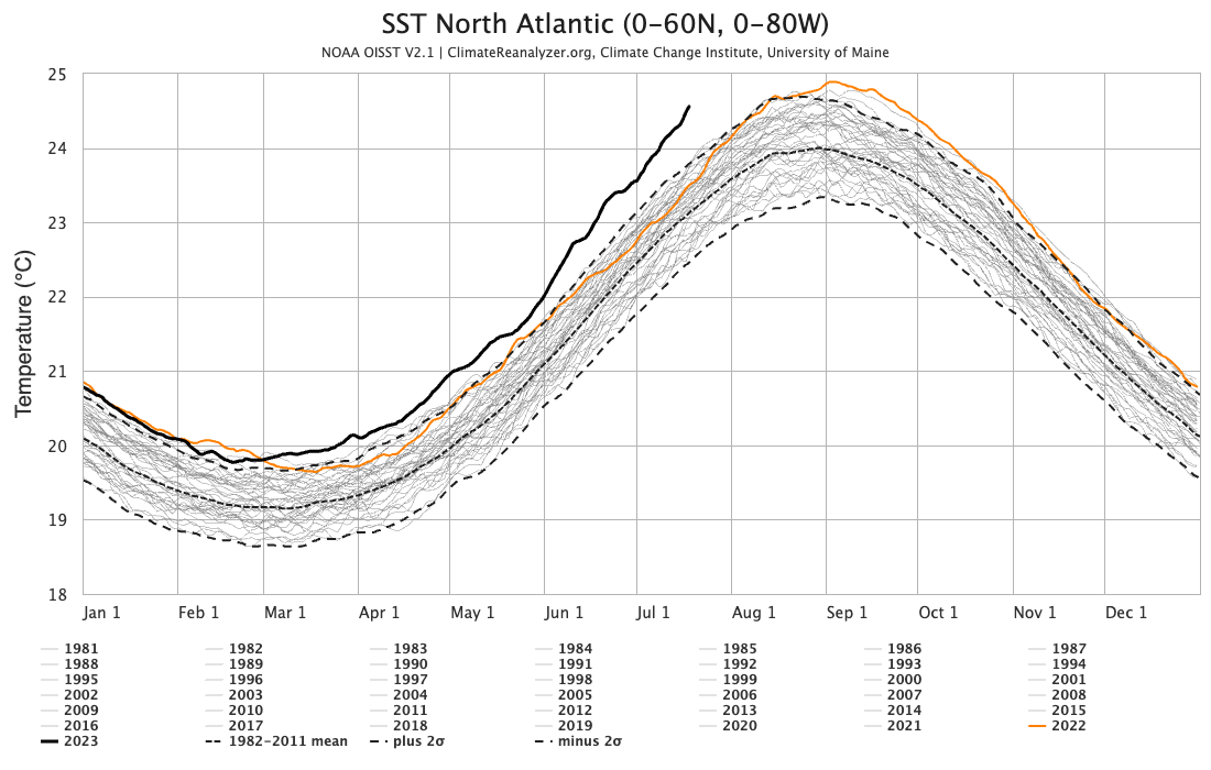
Water temps right now are more in line with what you would expect around Labor Day. It’s 83 at the Carolina coast, 87 in the Gulf Stream, and 91 at Key West. The slow start to the season also means that these waters have not been churned up… more Heat content is building up which means more energy for future storms to absorb.It’s a matter of time when those trade winds calm a little then things gonna go wild. Crazy water temps this time of year.
GFS says no curve on this one. Will the euro show something?Season of the Curveballs. Im expecting a lot of curves/fish storms. Looks like one might be forming over the eastern Atlantic right now

The GFS has more 384 US landfalls you can count. They must have it autoprogrammed to show big hurricane strikes and blizzards at the end of the run.GFS says no curve on this one. Will the euro show something?
Last night the Euro was showing something weak following the same path, but it just goes to 240The GFS has more 384 US landfalls you can count. They must have it autoprogrammed to show big hurricane strikes and blizzards at the end of the run.


EPS getting sniffy.
I'm heading to Puerto Rico next weekend too, going to have to keep an eye on this
This is the wave that the globals and esembles have been sniffing at for the last few days.Eastern Tropical Atlantic:
A tropical wave located a few hundred miles south of the Cabo Verde
Islands is currently interacting with the Intertropical Convergence
Zone. The combination of these features is producing a broad area of
showers and thunderstorms over the eastern and central tropical
Atlantic. While dry air to the north may prevent significant
organization during the next few days, environmental conditions
could become more conducive for some development by this weekend as
the wave moves westward across the central tropical Atlantic.
* Formation chance through 48 hours...low...near 0 percent.
* Formation chance through 7 days...low...20 percent.

AL, 95, 2023072100, , BEST, 0, 113N, 387W,
20/40Central Tropical Atlantic (95L):
A small area of low pressure, located several hundred miles
west-southwest of the Cabo Verde Islands, is producing an area of
disorganized showers and thunderstorms over the central tropical
Atlantic. Environmental conditions appear generally conducive for
some gradual development of this system, and a tropical depression
could form in the next several days, as it moves westward across
the tropical Atlantic.
* Formation chance through 48 hours...low...20 percent.
* Formation chance through 7 days...medium...40 percent.


