Downeastnc
Member
Good time to toss this in here....
Good time to toss this in here....

Good time to toss this in here....
True. At least we have something to watchMy posts weren’t to assume that it’s an OTS storm, more that it’s still way too far out to really know anything and that the operational models , specifically, the GFS are all over the place!


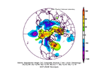
My take away is high latitude blocking, we’ll see what happens in the coming days!Here is the mean 500mb pattern for some of the more memorable hurricane hits in the Carolinas from cape Verde storms since hugo. The big precursors are the trough in the PNW or Northern plains and the big ridge in SE Canada. View attachment 136787
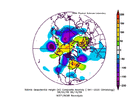
Now if you change the criteria the pattern changes. For a deep inland system Fran/Hugo the cutoff low similar to the overnight gfs appears View attachment 136788
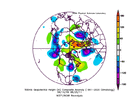
Here is what some of the I95 or east runners looked like Floyd/Irene
View attachment 136789
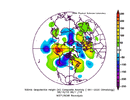
And finally some of the heavier blocked systems Isabel/Florence View attachment 136790
06GFS is not OTS. It does go more east and bypass us but then more west and hits Long Island

Northeastern Atlantic (ex-Franklin):
Post-Tropical Cyclone Franklin is located several hundred miles
north of the Azores and is forecast to move quickly southeastward
towards warmer waters east of Azores. This system could acquire some
subtropical or tropical characteristics late this week or this
weekend while it moves erratically between the Azores and Portugal.
For additional information on this system, including gale warnings,
see High Seas Forecasts issued by Meteo France.
* Formation chance through 48 hours...low...near 0 percent.
* Formation chance through 7 days...low...20 percent.
&&


And with that big high over NY very close to not being a fish.Fishy storm #2 days after. ACE Should be nice for September.

It’s moving NE at that frame as the H is moving in over NY It’s OTS with that look.And with that big high over NY very close to not being a fish.

