NoSnowATL
Member
Yes for sure. Those water are chilly.Probably will be a tropical storm.
Sent from my iPhone using Tapatalk
Yes for sure. Those water are chilly.Probably will be a tropical storm.
Sent from my iPhone using Tapatalk
Control took into the sea islands and basically along the SC coast up to Charleston. It's about a 24 hour coastal tour so I'd imagine a lot of weakening but a ton of rain.I am hoping people stay home and off the roads for Hilary, I was stationed in 29 Palms, and it’s surprising how little rain it takes to cause major issues! On another note , I know it’s way out and wrong atm but I wish the ECMFW went out further the 2 am run looked like a major for somewhere along the SE coast!
Thanks I left soaker out after the major! I’ll take all the rain I can get, even if in la la land!Control took into the sea islands and basically along the SC coast up to Charleston. It's about a 24 hour coastal tour so I'd imagine a lot of weakening but a ton of rain.

GFS is starting to come to the Euro. That makes me more confident a cane will be somewhere in the SW Atlantic in 10 daysOh wow

They need to start naming something.POSSIBLE LOW-LEVEL INVEST MISSION
OVER THE EASTERN CARIBBEAN NEAR 14.0N 65.5W FOR 20/1800Z.
Well the NHC is interested in something
It looks like it's forming a system off of the ITCZ then reforming off the coast of Nicaragua after the land passage. While it's rare, it's happened before. To what extent convection is disrupted from the mountains is unknown and reformation conditions at the time. My wow comment was in reference to the tropical system that recently went through the area causing catastrophic damage.Upon further review I dont think the GFS cane will happen. It comes from magic, from a storm that comes from the pacific and that almost never happens. It does show a depression north of the islands so thats the real show though the gfs just washes it out.
You can see where the FLA cane comes from and it seems unrealistic to me
You can also see another storm forming in the east pac and that will be what happens without the magic spnioff to the east.


Why?They need to start naming something.
 yaleclimateconnections.org
The season isnt matching expectationsWhy?

Guess Joe is buying into the El Nino induced TUTTVery disappointing Euro. The cane now is just a weak recurving low. there is another one that will recurve 1000 miles east of that and i weak crossover in the BOC that i just dont thing will happen. Joe Bastardi has cancelled a sept to remember and now says Sept will be below normal. Overall, its time to wait till next season and hope somehow the tropics will remember how to be favorable.
He doesnt say whyGuess Joe is buying into the El Nino induced TUTT
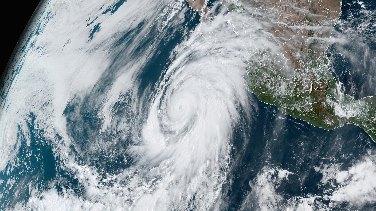
California's first Tropical Storm Watch on record as Hurricane Hilary heads for Baja » Yale Climate Connections
Even as it weakens, Hilary will pack an exceptional punch in the U.S. Southwest, with pockets of high wind and widespread flooding rains.

Very disappointing Euro. The cane now is just a weak recurving low. there is another one that will recurve 1000 miles east of that and 1 weak crossover in the BOC that i just dont think will happen. Joe Bastardi has cancelled a sept to remember and now says Sept will be below normal. Overall, its time to wait till next season and hope somehow the tropics will remember how to be favorable.
Something will go wrong next year too.Better luck next year

I wouldn’t live by model to model, there all over the place.GFS seems to have dropped the crossover but now it has a storm headed to PR

I but it doesnt snow here so aug-early oct is my only chance for interesting weather. It might be a monster if it didnt decide to visit every mt range in the caribI wouldn’t live by model to model, there all over the place.


That's a heck of a pattern out west with Hilary with the ull west of LA and the big death ridge to the east

")


Great weather board mantra to live by, give it a try06gfs is recurve city. No point in even posting a map.

