leaning toward flurriesTomorrow by 12z data, we're going to be looking down the barrel of a snowstorm, worrying about sleet or hanging onto flurries for dear life in Raleigh.
-
Hello, please take a minute to check out our awesome content, contributed by the wonderful members of our community. We hope you'll add your own thoughts and opinions by making a free account!
You are using an out of date browser. It may not display this or other websites correctly.
You should upgrade or use an alternative browser.
You should upgrade or use an alternative browser.
Misc 2021-22 Fall/Winter Whamby Thread
- Thread starter jackendrickwx
- Start date
Loganville Winter
Member
accu35
Member
I’m ready for my planting season, won’t be long to start on my garden and fertilize my fruit trees again. Plus build a new pin for my chickens
It's funny when the 850s are actually good,there's no precipitation. When there is precipitation, all the sudden,the warm nose wants to show itself. This is what sucks when it comes to being in the Midlands of SC and the CSRA. Shreveport, who have argually a worse snow climo had 2-3 snow events just last winter alone, but yet Columbia and Augusta are still looking for their first snow event since 2014.
Snowflowxxl
Member
I hate cold weather so I’m all for a pattern change if it’s not going to snow. I can put up with it though as long as we have chances

I just want an inch of snow, maybe a glaze of ice and some sleet pellets.
can we get a korea model update ... lmao
NBAcentel
Member
The bird actually won
Actually, we had a minor event in 2017 which produced about an inch (or two at most).It's funny when the 850s are actually good,there's no precipitation. When there is precipitation, all the sudden,the warm nose wants to show itself. This is what sucks when it comes to being in the Midlands of SC and the CSRA. Shreveport, who have argually a worse snow climo had 2-3 snow events just last winter alone, but yet Columbia and Augusta are still looking for their first snow event since 2014.
Regardless, I feel you. I thought this was our chance to finally score again and now it looks like Lucy pulling the ball away from Charlie Brown right at the last minute.
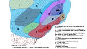
We're headed for a map like this aren't we 
Loganville Winter
Member
She messes up that dive about as bad as the models have messed up this beautiful set up.Time to head for the boards.
Oh yesWe're headed for a map like this aren't we View attachment 108339
lexxnchloe
Member
W e can still get a better trend starting tonight.
Montanasnow30
Member
I’m so ready for winter to be over with hell living up here we still haven’t had a decent snowstorm everything has been pure meh I’m tired of seeing flurries or a snow-shower fall I need a huge snowstorm so I can build a huge snowman make snow angels and knock  on folks doors so I can throw a snowball in their face and run and hide
on folks doors so I can throw a snowball in their face and run and hideLovingGulfLows
Member
- Joined
- Jan 5, 2017
- Messages
- 1,499
- Reaction score
- 4,100
Lol is Birdman about to score a coup here??? He's been honking the E NC only event for a while now.
uncjibble
Member

lexxnchloe
Member
Here is Raleigh wx's just issued forecast. Lets hope for a better trend.
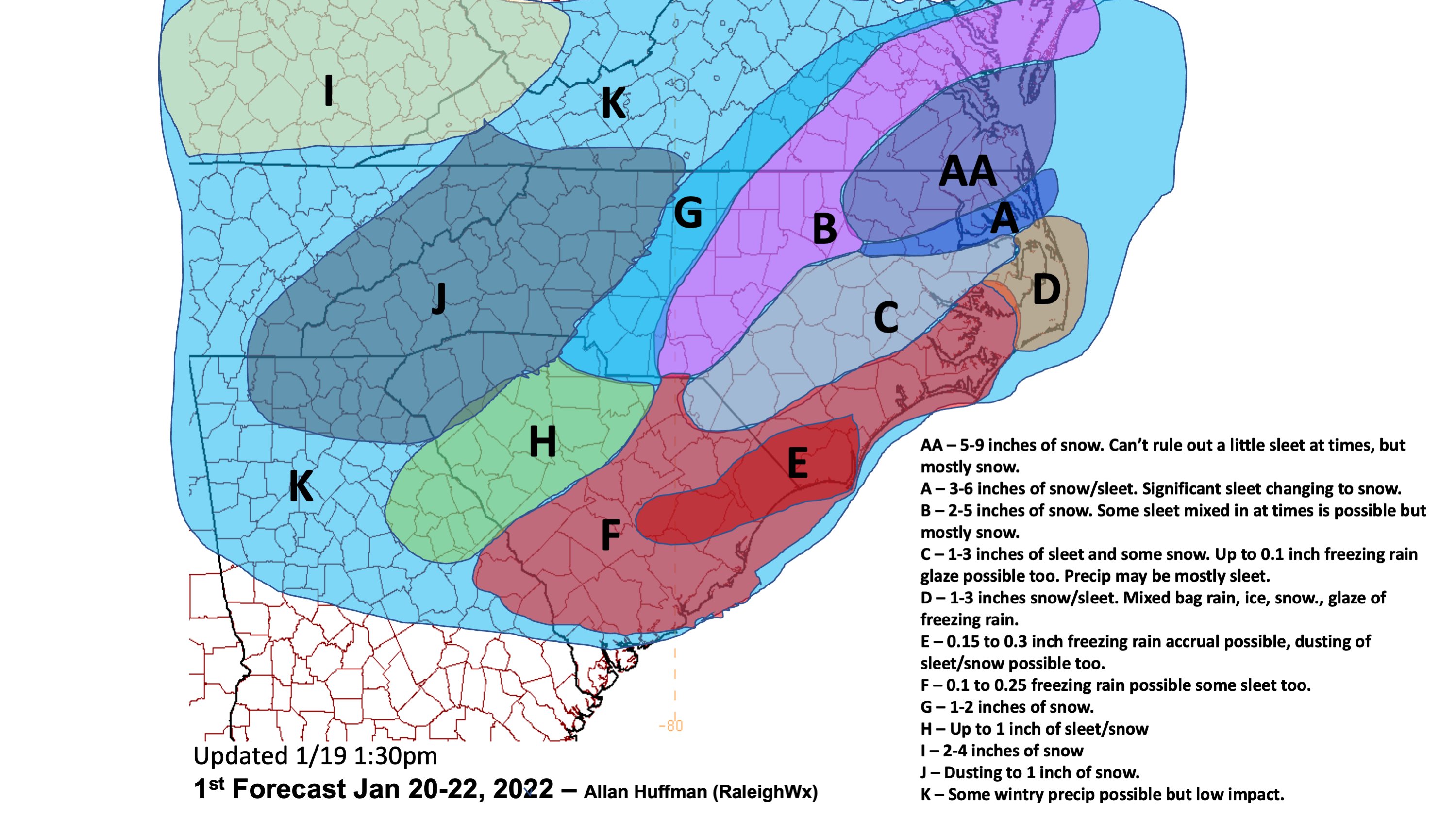
If C were snow instead of sleet they would probably be alot higher.
If C were snow instead of sleet they would probably be alot higher.
lexxnchloe
Member
Beat me by a hairI knew being in the A zone on one of Allan Huffman's maps was too good to last... I am now dangerously close to CView attachment 108343
Does anyone know if my maps get posted on the other board now maybe they need to
I know some joke around about having so many zones with his maps, but that just tells me how much effort he puts into it.I knew being in the A zone on one of Allan Huffman's maps was too good to last... I am now dangerously close to CView attachment 108343
GeorgiaGirl
Member
I just rage powered off my computer because the mouse didn’t want to act right, so that’s fun.
Maybe it’ll work right now that I turned it back on.
Maybe it’ll work right now that I turned it back on.
D
Deleted member 609
Guest
You should tweet it to the authoritiesDoes anyone know if my maps get posted on the other board now maybe they need to
lol, Birdman programing the models in the back room, He's a step ahead of them!!! ????Lol is Birdman about to score a coup here??? He's been honking the E NC only event for a while now.
I'll be happy if we get 3 or 4 inches with snow falling in the 20s, better than most winters around here
We're headed for a map like this aren't we View attachment 108339
I would take that in a heartbeat...most snow since 2018.
packfan98
Moderator
It's BRUTAL today! We have the cold air without a flaming warm nose and the storm fizzles out. I have to find a better hobby.
Loganville Winter
Member
Solidly in K! Let’s go!I knew being in the A zone on one of Allan Huffman's maps was too good to last... I am now dangerously close to CView attachment 108343
Dewpoint Dan
Member
Birdman is smarter than people give him credit for.
L
Logan Is An Idiot 02
Guest
Birdman is smarter than people give him credit for.
I’m not mad that I’m not getting snow. I’m mad that birdman was right lol
Sent from my iPhone using Tapatalk
Heelyes
Member
My god the dark side is melting down, it's pure gold.
lexxnchloe
Member
Im going to go out on a limb and say the 18Z models will step a bit back in the right direction. The Euro was the last to come out at 12Z and it didnt go down as much as the other models. Come mid day tomorrow im hoping we are looking at a better outcome.
Snowed In
Member

BufordWX
Member
I’m back in Oklahoma now. Gotta love that Oklahoma winter. It was 70 yesterday.
From what I saw,outside of the SE Virgina and NE North Carolina,the Euro was the driest out of any other model I saw. In fact precipitation amounts was under .50 for most areas south of the US 70 and areas west of the I-95 corrdior. Also there was basically no precip at all for a huge chuck of South Carolina with the highest amounts being under .30. Maybe this trends better for some areas as we get closer,but this is quickly trending toward being a non event for most if not all of South Carolina if the Euro is correct.Im going to go out on a limb and say the 18Z models will step a bit back in the right direction. The Euro was the last to come out at 12Z and it didnt go down as much as the other models. Come mid day tomorrow im hoping we are looking at a better outcome.
Last edited:
Birdman is smarter than he lets on and I actually get a lot of entertainment out of his stuff but calling for lower precip totals back west and higher totals towards the coast in a late bloomer setup is not really putting your neck on the line. Easy low risk high probability call imo.Birdman is smarter than people give him credit for.
Loganville Winter
Member
Getting all this attention about his predictions with an easy low risk high probability call is brilliant in itself.Birdman is smarter than he lets on and I actually get a lot of entertainment out of his stuff but calling for lower precip totals back west and higher totals towards the coast in a late bloomer setup is not really putting your neck on the line. Easy low risk high probability call imo.
My snow is getting lonely ?
Brent
Member
Well I have sleet ?
Unfortunately moisture is evaporating before it gets cold enough to really snow of course
Unfortunately moisture is evaporating before it gets cold enough to really snow of course