Well you win some, you lose some on to the next. At least I'll get some work done and some sleep rest of the week
-
Hello, please take a minute to check out our awesome content, contributed by the wonderful members of our community. We hope you'll add your own thoughts and opinions by making a free account!
You are using an out of date browser. It may not display this or other websites correctly.
You should upgrade or use an alternative browser.
You should upgrade or use an alternative browser.
Misc 2021-22 Fall/Winter Whamby Thread
- Thread starter jackendrickwx
- Start date
Montanasnow30
Member
I wonder since this event for the weekend may only be affecting the Carolinas will the rest of the south who hasn’t seen accumulating snow get a chance
Dewpoint Dan
Member
A Winter Storm Watch is in effect in TX for locations at the same latitude as West Palm Beach, FL. Unreal.
BHS1975
Member
You went there. Damn
Me too was crazy. Waste deep in snow.
Sent from my iPhone using Tapatalk
Storm trending SE creating some room to spare when it bubbles back NW in the last 24 hours like they always do? I missed the memo of that being bad.
Loganville Winter
Member
I seem to remember more weather educated folks than myself saying that the WAR always kept trending stronger when it got started. What is causing this to do the opposite and do we think the models are handling this correctly considering it is seemingly out of the ordinary?
L
Logan Is An Idiot 02
Guest
I do not understand brad p at all.
Sent from my iPhone using Tapatalk
Sent from my iPhone using Tapatalk
ummmmm isn't that a good thing?Storm trending SE creating some room to spare when it bubbles back NW in the last 24 hours like they always do? I missed the memo of that being bad.
Waiting for the euro like 
Historically yes, reading this board you would have thought this thing was in Burkina Faso nowummmmm isn't that a good thing?
BHS1975
Member
Storm trending SE creating some room to spare when it bubbles back NW in the last 24 hours like they always do? I missed the memo of that being bad.
Especially for you down in the Amazon.
Sent from my iPhone using Tapatalk
D
Deleted member 609
Guest
Storm trending SE creating some room to spare when it bubbles back NW in the last 24 hours like they always do? I missed the memo of that being bad.

BHS1975
Member
Me too was crazy. Waste deep in snow.
Sent from my iPhone using Tapatalk
And I had a Harris Teeter right across the street. Fun times.
Sent from my iPhone using Tapatalk
navgem brought out. watch out bois
Storm trends NW last minute …
Everyone: well we knew that was coming! Fail!!!! Weenie!
Storm makes a SE trend with still 48 hours to go
.. it may go back NW with the NW trend last minute
Everyone: NO WAY WEENIE THIS THING IS TOAST .. SUPPRESSION!!!
Everyone: well we knew that was coming! Fail!!!! Weenie!
Storm makes a SE trend with still 48 hours to go
.. it may go back NW with the NW trend last minute
Everyone: NO WAY WEENIE THIS THING IS TOAST .. SUPPRESSION!!!
Guilty lol. I'm with you 100%Historically yes, reading this board you would have thought this thing was in Burkina Faso now
Lol what’s it showingnavgem brought out. watch out bois
I’m ready for a pattern change, our best storms come as the pattern relaxes! ?
 ?
?Lol what’s it showing
likely a wrong solution but the frame i saw was more moisture i guess

Us vs SE trends
This thing needed to start trending NW 2 days ago for my area to have a chance. This morning's model runs have put the proverbial tail rope on the tuna.


I'm ordering seeds for the garden today. 
I’m now legitimately more worried about getting enough precip back this way than about sleet. ?
L
Logan Is An Idiot 02
Guest
Anyone know what model brad p was showing? It was showing a lot of precip
Sent from my iPhone using Tapatalk
Sent from my iPhone using Tapatalk
Nevermind. The GEFS is causing me to have second thoughts. It's enough of a signal for a bigger event that I have closed my seed catalog and I am now looking at generators and soup again.
Y’all are spoiled! If the only thing on the table was the analfrontal 1-2” of slop, most winters it would be ? worthy! Y’all greedy
Are there h500 vort charts for the individual GEFS members?
I’m now legitimately more worried about getting enough precip back this way than about sleet. ?
I keep forgetting who we are...the last thing we want is this to be hugging the coast. If we could draw it up at 60 hours we would be drawing what we are seeing now.
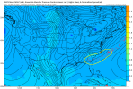
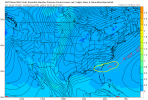
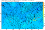
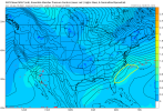
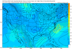
I don't have good maps, but as the images progress, there's still some members trying to do something either with a slower or second wave.. I highlighted my areas of concern versus the operational runs. These positions and strength greatly effect what people see weather wise, imo.
Edit: image 4 into 5 is my primary concern
Edit: image 4 into 5 is my primary concern
Attachments
accu35
Member
I’ll be careful next time when asking for a SE trend.
When I’m sitting in my apartment listening to the sleet bounce off my windows in a couple days, I’ll yawn at this post, I’m sure.I’m now legitimately more worried about getting enough precip back this way than about sleet. ?
Snowflowxxl
Member
Brick, stop stealing our maps challenge
packfan98
Moderator
Who gets more, Durham or High Point?When I’m sitting in my apartment listening to the sleet bounce off my windows in a couple days, I’ll yawn at this post, I’m sure.
At this point I would be shocked if it weren’t Durham, but we live in reality and it’s hard to imagine that actually happening. The Triad always wins somehow. ?Who gets more, Durham or High Point?
Worth the precip field looking a bit east at the moment, I suppose it’s time to start drawing some comparisons with January 2000? modernweenie
Dewpoint Dan
Member
I've been assured that the last 2 weeks of Jan will be epic. So I'm 100% expecting a good snow for the I-20 corridor very soon.
- Joined
- Jan 5, 2017
- Messages
- 3,809
- Reaction score
- 6,066
Ha ha ha ha ha....good one!I've been assured that the last 2 weeks of Jan will be epic. So I'm 100% expecting a good snow for the I-20 corridor very soon.
Dewpoint Dan
Member
I mean there's no way Atlanta escapes this epic pattern without at least an inch of snow. Right ?Ha ha ha ha ha....good one!
“Does not like to make decisions for people”