B
Brick Tamland
Guest
wouldn't this be something, especially if dorian ends up hitting this area

It seems once we have a legit threat in the tropics in September it just breeds more threats.
wouldn't this be something, especially if dorian ends up hitting this area
That's how I remember it sonnyI think it was connie, debbie, ione in 55
Sent from my SM-G975U using Tapatalk

Unbelievable!!!! I know it's not likely correct with the models forecasting tropical cyclone locations 14 1/2-15 days out but you never know. As if Dorian was not devastating enough the Bahama's. The 9/4 00Z GFS stalls another hurricane for about 30 hours from hour 354-378 within about a 100 mile radius of where Dorian stalled
Same storm: 12z GFS Legacy, plows into the shredder. Oz euro was curving ots, further north.
View attachment 23214

The Euro isn’t OTS. In fact that is a very nasty look considering the big ridge we can’t get rid of in the long range.
I disagree. That’s OTS based on the position as well as based on the 0Z EPS, which had a good number of members with a TC near there which then all went easily OTS.
It hopefully will end up as a moot point as the 12Z Euro dropped it. Even many posters here are tired out from Dorian and have had enough. I’m exhausted. The SE has had a very rough 4 seasons in a row. Enough already. Hopefully this is the only threat this season and we can finally have some peace and quiet.
Looks like another long tracker on the GFS.
Sent from my iPhone using Tapatalk
Looks like another long tracker on the GFS.
Sent from my iPhone using Tapatalk
The 12Z GFS also has it.
Just fyi, this is 94L and we have a thread for it already12z canadian as well

Interesting, but until something forms, awfully difficult to look into the crystal ball ...Fwiw, the 12Z EPS has a fairly strong signal for what I think is the wave FOLLOWING 94L with very roughly 50% of the ~51 members having a TC genesis though most don't form til the vicinity of the Antilles or Bahamas days 11-14. Most of these then recurve between the US east coast and Bermuda. Regardless of the suggested track, this may very well eventually be an additional threat in the western basin. We'll see.
This wave is currently still over Africa and it will reach the ocean in a couple of days.
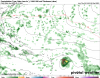
12Z EPS TC centers at hour 360:
View attachment 23266
Interesting, but until something forms, awfully difficult to look into the crystal ball ...
Wasn't suggesting otherwise, Larry, and agree 110% ...The key is that models are not crystal balls but instead are tools. Anyone who treats them as crystal balls is misusing them. But using them as the tools that they are is different. Some of these tools are better than others, too. In addition, a tool is only as good as the tool user.
Hopefully, nothing forms from this or from 94L and we have limited threats the rest of the season. The good news is that there's a decent chance that Dorian will turn out to be the worst threat of the season, by far, since it was a humdinger. That would be more than fine with me. Many seasons have one storm that sticks way out for the SE. Maybe that will be Dorian. Storms like Andrew, Hugo, Camille, and Betsy were by far THE storms of the season. The peak is within a few days and then it is downhill, thank goodness.