• Hello, please take a minute to check out our awesome content, contributed by the wonderful members of our community. We hope you'll add your own thoughts and opinions by making a free account!

Wintry 2/11-2/12 ULL Magic or More Cold Rain

People are all doom because it didn't go well in the carolinas but I have to question if it made it better or worse for GA so I know if I should be with you hoping it to stop or hoping it stays like this.

Now that I see the above I hope it goes back
That wouldn’t have ended well for Georgia either. That was going to be a Nashville special.
 
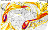
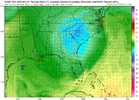
A view of the cold temperatures that the upper low is bringing with it aloft (from 12z Euro at 700mb)...

VCMRvpy.gif
There’s no cold air to tap! How’s this possible
 
Is the 18z GFS more accurate than the 12z Euro? I've always wondered this, but dunno if anyone tracks verification scores like that.
I've not seen statistics on this, but I imagine that the 18z GFS would be more accurate than the 12z ECMWF for closer range forecasts, and the 12z ECMWF would be more accurate in the longer range (>48hrs).
 
That wouldn’t have ended well for Georgia either. That was going to be a Nashville special.
IDK. I would think that cole-core would slide ENE tucked in behind the developing coastal. I'll take my chances with that stout UUL moving northeastward from south central Ga.
 
Here in SC you could have every model on your side except one. And deep down you know that one, regardless of which one it is will be correct and all the others will cave to it. Goofus will still be Goofus for awhile. We'll get NAM'd and other short range models will offer hope. But I'd bet the farm they all look like the 18Z Euro just did once we get inside 24 hrs. I've been around too long to fall for it.
 
IDK. I would think that cole-core would slide ENE tucked in behind the developing coastal. I'll take my chances with that stout UUL moving northeastward from south central Ga.
Yeah that Euro run was a little bit surprising that the track of the surface low stayed the same while the upper low shifted west. You would think that the upper low would follow in tandem with a deepening surface low on the coast
 
Here in SC you could have every model on your side except one. And deep down you know that one, regardless of which one it is will be correct and all the others will cave to it. Goofus will still be Goofus for awhile. We'll get NAM'd and other short range models will offer hope. But I'd bet the farm they all look like the 18Z Euro just did once we get inside 24 hrs. I've been around too long to fall for it.
Preach brother. I hate to hear it but your probably going to be right. I hope not but we haven't caught a break around here in a long time.
 
Here in SC you could have every model on your side except one. And deep down you know that one, regardless of which one it is will be correct and all the others will cave to it. Goofus will still be Goofus for awhile. We'll get NAM'd and other short range models will offer hope. But I'd bet the farm they all look like the 18Z Euro just did once we get inside 24 hrs. I've been around too long to fall for it.
You must be in Beaufort or Charleston,
Maybe the midlands?
 
Upper level lows are crazy. I remember not having any snow expected in March of 2009 and then it came out of nowhere. I was a freshman in high school and was at the state basketball playoff games and came out to winter storm warnings about 24-36 hours before it started.

With these massive changes 84-96 hours out, there is no telling what this system will do. I’m still keeping an eye on it even for our area. I just hope someone on here gets smoked who hasn’t seen snow in awhile!
 
Back
Top