Tsappfrog20
Member
Winter Weather Advisory Just Issued for the Triangle Area!!
Sent from my iPhone using Tapatalk
Sent from my iPhone using Tapatalk
That may actually help the trough dig a little bit more. Something to kind of keep an eye on as we move forward. Rooting for all the NC winter weather fansStronger wave on 17z hrrr vs 12z

Sent from my iPhone using Tapatalk
Here’s the wording:Winter Weather Advisory Just Issued for the Triangle Area!!
Sent from my iPhone using Tapatalk

Here’s the wording:
...WINTER WEATHER ADVISORY IN EFFECT FROM 7 AM MONDAY TO NOON EST
TUESDAY...
* WHAT...Snow expected. Total snow accumulations ranging from around
half inch across the Triad and Triangle regions and up to 2 inches
near the NC/VA border. In addition, lingering moisture could
result in black ice late Monday night into Tuesday morning.
* WHERE...Northern Piedmont and northern Coastal Plain.
* WHEN...From 7 AM Monday to noon EST Tuesday.
* IMPACTS...Plan on slippery road conditions. The hazardous
conditions could impact the Monday morning and evening commutes.
Black ice could impact Tuesday morning commute.
* ADDITIONAL DETAILS...Temperatures are expected to fall rapidly
Monday evening, reaching the mid/upper teens Tuesday morning.

Maybe it is finally starting to bite. Would be nice to see it increase the totals to what the GFS and short range models are showing.12z Euro beefed up the totals and is now more in line with other modeling.
View attachment 178392


That is my thinking, too. I would move each zone in Allan's call map a little further south.Here is DT’s First Guess
Sent from my iPhone using Tapatalk
DT’s crayon maps always make me chuckle - just aesthetically, that is. I tend to find his analysis and forecasts very sharpHere is DT’s First Guess
Sent from my iPhone using Tapatalk
He's been making them the same way for 20 yearsDT’s crayon maps always make me chuckle - just aesthetically, that is. I tend to find his analysis and forecasts very sharp
I'm pulling for ya Fro..you and @griare pretty snow starved like us upstate and ne ga peasants are.First call map of tomorrow’s event View attachment 178332
Has the best handle on this one imo. Usually does real well with marginal set ups.3K NAM looks good!!

Sent from my iPhone using Tapatalk
Has the best handle on this one imo. Usually does real well with marginal set ups.
Not sure if thats good for your location but I hope you get a coating as well kind sir!

Usually gotta slash his totals by 75%+.Here is DT’s First Guess
Sent from my iPhone using Tapatalk

The cold temperatures overnight is going to cause a mess for any area that gets significant precipitation, snow or not. This is definitely going to make this event a higher impact than last week for most. I’m afraid folks will be caught off guard.

Yeah, same here. Still 39.Don’t know if it’ll matter but it’s almost 3 and we’re nine degrees off our high on the low side
Can't hurt, that's for sure.Don’t know if it’ll matter but it’s almost 3 and we’re nine degrees off our high on the low side
Looks like the hrrr with anemic outputs for nc. Hopefully the 3k is better and the 0z run will be more in line with other precip outputs.

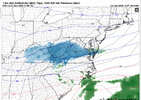
Hope it is just a wonky run and not the start of the models doing a 180.One would think this would fill in. It definitely looks wonky.
View attachment 178403
One would think this would fill in. It definitely looks wonky.
View attachment 178403