WolfpackHomer91
Member

Can the amount of precip on the NAM be trusted?


Yeah, just hard to trust it with all the mets discounting it and calling it a trash model. I think all the local TV mets here just look at the Euro for their forecasts. I don't even think they trust the short range models. I think they would rather bust calling for too little snow than the other way around.Man I hope the GFS is right!!!
Sent from my iPhone using Tapatalk

Snow is way south of what the local mets here are saying.
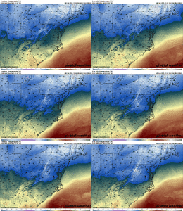
12z HREF at 19z
Sent from my iPhone using Tapatalk


my little pocket of NE Durham somehow still holding on to the very last edges of precip shield in 23z lol but overall this would be a solid but very QUICK showing of snow across the Triangle


20-23z HREF
Sent from my iPhone using Tapatalk
1 to 2 inches this early in winter would be a big win.my little pocket of NE Durham somehow still holding on to the very last edges of precip shield in 23z lol but overall this would be a solid but very QUICK showing of snow across the Triangle
oh, agreed! and you're in that same little pocket, on the Wake Forest side1 to 2 inches this early in winter would be a big win.
Chris went to NC State and attended high school in the area.Chris Michaels is relatively new to the area and North Carolina as a meteorologist at WRAL so all I'll say is that he may be in for a surprise come Monday if these model trends keep swinging our way. Greg Fishel got burned when he said that Raleigh would not get an inch of snow when a system like this came our way one time. He was a man of his word and did his next broadcast standing in the fountain at WRAL.
The inverted trough feature may drop 8+ on someoneMan I hope the GFS is right!!!
Sent from my iPhone using Tapatalk
Someone go to Boone and check it out. Models don’t normally resolve these inverted troughs well so the fact that all of them are showing it means the snowfall could be pretty damn dynamicThe inverted trough feature may drop 8+ on someone
HRDPS has it aswell

Tazewell to Grayson County to Boone.The inverted trough feature may drop 8+ on someone
HRDPS has it aswell
That's good to know. I do hope his initial forecast for this event is too conservative for this storm.Chris went to NC State and attended high school in the area.

Pretty much every global is increasing QPF, GFS most aggressive View attachment 178393View attachment 178394View attachment 178395
Am curious to see which Mets buy into the coastal enhancement potential vs not. Looks like Allan is a nay on thatAllan’s First Guess Map

Sent from my iPhone using Tapatalk
I love that arch over Surry County; I happen to live under the arch! lol12z Euro beefed up the totals and is now more in line with other modeling.
View attachment 178392
Since the GFS is the model that is bringing the coastal enhancement, Allan is being conservative probably due to the GFS forecasting track record and the fact that it is showing the most coastal enhancement. I think he is in wait and see mode as many of us are and he will adjust this map accordingly as model trends dictate. I have always liked Allan's input when it comes to weather events.Am curious to see which Mets buy into the coastal enhancement potential vs not. Looks like Allan is a nay on that
Yeah, most of the models show a max from SW VA to Western NC.I love that arch over Surry County; I happen to live under the arch! lol
