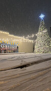
Moderate snow at airport GSO now. Heading home
-
Hello, please take a minute to check out our awesome content, contributed by the wonderful members of our community. We hope you'll add your own thoughts and opinions by making a free account!
You are using an out of date browser. It may not display this or other websites correctly.
You should upgrade or use an alternative browser.
You should upgrade or use an alternative browser.
Wintry 1/9-12 Winter Potential Great Dane or Yorkie
- Thread starter SD
- Start date
rburrel2
Member
No promises, but I think that band is gonna be chicken feathers for me and you. Fingers crossed!Same here...heavy rates about to show up at the wrong time I'm afraid. Maybe not
I don’t believe it cause I’m dry as a bone and have been for about an hour now. NothingAll short term models show a crippling ice storm for Northeast GA and the upstate of SC...
its snowing in PendletonI don’t believe it cause I’m dry as a bone and have been for about an hour now. Nothing
norcarolinian
Member
first flakes falling now NW Guilford
NEGaweather
Member
3 inches of snow and now trees beginning to get a coat of ice at 30 degrees
Sent from my iPhone using Tapatalk
Sent from my iPhone using Tapatalk
- Joined
- Jan 5, 2017
- Messages
- 3,774
- Reaction score
- 5,985
32.0 and light freezing rain.
Cary_Snow95
Member
This blob over GSO almost seems to want to go southeast. Interesting
iGRXY
Member
It’s still snowing very hard here. Not an ounce of sleet yet
a_gilmore88
Member
Still waiting on our first precipitation in southern Rowan County. That band that dropped a quick dusting Salisbury and points north just completely skipped over us.
Sent from my iPhone using Tapatalk
Sent from my iPhone using Tapatalk
And this friends is the benefit of extreme northwest Spartanburg county. Seen it time and time againIt’s still snowing very hard here. Not an ounce of sleet yet
rburrel2
Member
What's weird is i've got dendrites falling here but they're like shards of glass and heavy. Basically sleet... but they're dendrites? They're not mangled either; perfectly formed.
Coming down pretty good in Pilot Mtn.

Sent from my iPhone using Tapatalk

Sent from my iPhone using Tapatalk
WolfpackHomer91
Member
Flurries in Mooresville off Linwood Road / 152
Sent from my iPhone using Tapatalk
Sent from my iPhone using Tapatalk
NWMSGuy
Member
wow
Member
Getting a little darker. Should start any minute...Still waiting on our first precipitation in southern Rowan County. That band that dropped a quick dusting Salisbury and points north just completely skipped over us.
Sent from my iPhone using Tapatalk
can confirm, a few snow flakes finally floating down here right off Faith Rd
coldspringsfarm
Member
Ice accrual update? Seems to be doing a decent amount of freezing rain but little accrual currently…does that change as we go into the late afternoon evening-will we start to see issues, or will we remain at status quo? Interested in current thoughts…?
Wondering that myself. The HRRR is at least initializing with the correct temps right now (for me) and this is what it shows for freezing line around midnight, then it retreats north after that. Not too sure if any models are to be trusted with surface temps right now though, based on comments from my local NWS office.

Yes it was based on all the earlier forecasts. I have children in Sandy Springs & Carrollton and they scored much better so happy for all of them. We were under returns a long time without anything hitting the ground. I am guessing that our dewpoint was so low that it took a longer time to saturate the column. Once it did, it came down hard for a while which was nice. Then the warm nose caught up with us.It is amazing how much more snow ATL got, not rubbing it in,,, just bizarre modeling.
Hopefully we all will have a few more shots in the coming weeks!
SimeonNC
Member
Snow rate steadily picking up
The precipitation started as just snow. No sleet, although we might have some mixing issues, but the radar downstream looks promising. The cliff divers can finally breathe a sigh of relief and relax. Haha! Let’s see what happens!
wow
Member
flurries have begun
Temp dropped to 31 or so. Very very light freezing drizzle.
SnowNiner
Member
Gentle light/snow flurries have begun in Troutman. Let's see where it goes....
Cary_Snow95
Member
35.6 in Cary. Certainly a plus to get our precip after sundown
Twister
Member
Likely ZRIt’s raining here.
I thought that was supposed to start later?Likely ZR
My parents in GSO said it started snowing at 2:20pm and it’s already accumulating.
Snow sleet mix now getting heavier
WolfpackHomer91
Member
Still waiting on our first precipitation in southern Rowan County. That band that dropped a quick dusting Salisbury and points north just completely skipped over us.
Sent from my iPhone using Tapatalk
Yea, mother in law called from Faith Rd (Salisbury) And they had a Dusting bout 45 min ago. Right By Sheetz/Julian area
Sent from my iPhone using Tapatalk
a_gilmore88
Member
flurries have begun
Still nothing down here in Landis…
Sent from my iPhone using Tapatalk
a_gilmore88
Member
And as I say that, our first flakes have begun to fall. Original forecast was between 2:30-3 so that was dead on.
Sent from my iPhone using Tapatalk
Sent from my iPhone using Tapatalk
RDUHeatIsland
Member
Any reports from the stuff making its way through Chatham/Lee/Moore? All virga?
D
Deleted member 609
Guest
I think the sun is trying to come out
JimBobs
Member
90% sleet right now in Charlotte. You can hear it.
Snowflowxxl
Member
Yep also have light ZR here as wellTemp dropped to 31 or so. Very very light freezing drizzle.


