-
Hello, please take a minute to check out our awesome content, contributed by the wonderful members of our community. We hope you'll add your own thoughts and opinions by making a free account!
You are using an out of date browser. It may not display this or other websites correctly.
You should upgrade or use an alternative browser.
You should upgrade or use an alternative browser.
Wintry 1/9-12 Winter Potential Great Dane or Yorkie
- Thread starter SD
- Start date
ForsythSnow
Moderator
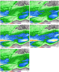
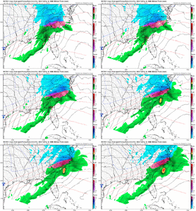
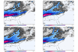
18Z RGEM continues to get colder and increase snow totals.
ChattaVOL
Member
Pops
Member
Being conservative..and rightfully so..but who knowsMemphis has lowerd my totals to 1-3 inches. i dont understand that logic at all.
SnowNiner
Member
18Z RGEM continues to get colder and increase snow totals.
I wish NWS GSP were leaning toward it. They’re leaning toward the NAM of course. Sleet in my forecast.
beanskip
Member
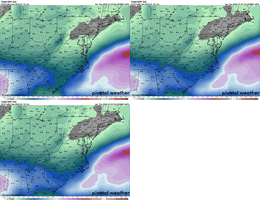
Really nice QPF increase for N. Georgia on ICON. Not so much for Carolinas, but still fine.
We're inching towards .5 qpf all frozen and that's major regardless of predominant p-type
You are in the mid south I hear. Do you really think the amount of snow you will get is predicated on what a few people in an office in MEM says you are going to get? I mean you are in the mid south. Just follow the models like the rest if us weenies that don't live in the mid south. 
Sorry, just giving you a hard time. I think you will do okay.

Sorry, just giving you a hard time. I think you will do okay.
Not happy about the decrease back my way, but this looks really good for NC/SC overall
Snow, sleet then a layer of .25 in ice would be some epic sledding weather for some of the Metro ATL.
Greenville county schools closed tomorrow already!
WxBlue
Meteorologist
UNC Asheville ATMS Department are launching weather balloons for this event. If things are still the same from when I did this job back in mid-2010s, balloons should be every 3 hours starting at 9 am Friday.
whizrtr
Member
Afternoon disco from BMX... forecasting a lot of sleet for our area.
Discussion...
We are dealing with a difficult forecast for late tonight and
Friday due to a late shift in the model guidance, led by the NAM
and followed by the global models. The shortwave trough
approaching the Mississippi Valley has trended more amplified
resulting in a stronger 850 mb low-level jet farther inland over
MS/AL and stronger warm advection in the 850-700 mb layer.
As precipitation overspreads the western and central counties
around 3 AM, forecast soundings are increasingly exhibiting a
warm nose around 750 mb, which is expected to be warm enough to
cause partial melting of snowflakes. Wet bulb temperatures below
this layer should be 2-4 C below freezing, which should allow for
the formation of ice pellets. Across our far northern counties,
thermal profiles are more supportive of a snow/ice pellet mix
within the first 2-4 hours of the onset.
By 6 AM, precipitation should be ongoing across most of the
forecast area with a potential for accumulating moderate to heavy
ice pellets as long as the melting layer aloft remains shallow
and colder than +3 C. If this layer is warmer, we`ll be looking
at an earlier transition to freezing rain in the Winter Weather
Advisory area.
Along the US-278 corridor, 0.5 to 1 inch snow appears possible
before precipitation changes to ice pellets. As warm advection
leads to additional warming at 800-750 mb, and where surface
temperatures remain below freezing, a transition to freezing is
expected in the 7-10 AM time frame from south to north. The best
chance for ice accumulations greater than 0.10 inch will be in the
Winter Storm Warning area, and in particular to the east of I-65
and north of I-20 in the higher elevations.
By noon, a sharp warm nose aloft should eliminate snow and sleet
as possible precipitation types. Where cold air lingers in the
higher elevations of the northeastern counties, additional
freezing rain accumulation may occur.
87/Grantham
I like the idea of the RGEM but I don't agree with the finger band being a band of freezing rain for areas further South like it's showing.
whizrtr
Member
Bigedd09
Member
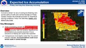
He literally said a couple hours ago that it would be an ice storm and not sleet. Dude needs to make up his mindB Rad latest thoughts, doesn’t shock meView attachment 161988
current Obs here on da Coast, (Topsail, nc)..
DOT is brining the roads..
Temp forecast has busted..
(We were forecasted, to get too 45F today)..
currently 37F under clear Skies.. never even reached 40F
DP of 10F
DOT is brining the roads..
Temp forecast has busted..
(We were forecasted, to get too 45F today)..
currently 37F under clear Skies.. never even reached 40F
DP of 10F
ChattaVOL
Member

Sent from my iPhone using Tapatalk
That’s actually the same thing I took from the GSP discussion. Maybe he’s actually looking at soundings and 925mb temperatures and seeing that they are not ZR soundingsB Rad latest thoughts, doesn’t shock meView attachment 161988
WxBlue
Meteorologist
B Rad latest thoughts, doesn’t shock meView attachment 161988
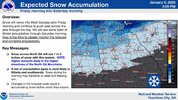
It's probably easier to just say it'll be a combination of snow, sleet, and freezing rain with accumulations from all of them being my forecast rather than a straight snowfall forecast.
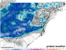
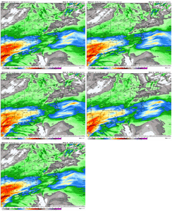
Euro AI has ticked NW with low track and temps aloft each of its last 4 runs with sfc temps holding for the most part. It looks like a typical Carolina storm with mix from Charlotte to RaleighLooks like Euro AI increased QPF across NC a little but I don't have p-type maps
View attachment 161982

PARSONBROWN
Member
Basically what Huntsville didIt's probably easier to just say it'll be a combination of snow, sleet, and freezing rain with accumulations from all of them being my forecast rather than a straight snowfall forecast.
URGENT - WINTER WEATHER MESSAGE
National Weather Service Huntsville AL
225 PM CST Thu Jan 9 2025
ALZ001>010-016-TNZ076-096-097-101200-
/O.CON.KHUN.WS.W.0001.250110T0600Z-250111T1200Z/
Lauderdale-Colbert-Franklin AL-Lawrence-Limestone-Madison-Morgan-
Marshall-Jackson-DeKalb-Cullman-Moore-Lincoln-Franklin TN-
Including the cities of Lynchburg, Red Bay, Moulton,
Russellville, Fayetteville, Decherd, Sewanee, Cowan,
Guntersville, Decatur, Albertville, Huntsville, Athens, Estill
Springs, Cullman, Rainsville, Boaz, Winchester, Florence,
Scottsboro, Town Creek, Sheffield, Fort Payne, Muscle Shoals,
Arab, and Tuscumbia
225 PM CST Thu Jan 9 2025
...WINTER STORM WARNING REMAINS IN EFFECT FROM MIDNIGHT TONIGHT TO 6
AM CST SATURDAY NORTHERN ALABAMA AND SOUTHERN MIDDLE TENNESSEE...
* WHAT...Heavy mixed precipitation expected Northern Alabama and
Southern Middle Tennessee. Total snow and sleet accumulations of 1
to 5 inches and ice accumulations up three tenths of an inch.
* WHERE...All of north Alabama and southern middle Tennessee.
* WHEN...From midnight tonight to 6 AM CST Saturday.
* IMPACTS...Plan on slippery road conditions. The hazardous
conditions could impact the Friday morning and evening commutes.
Stormsfury
Member
A little Miller A/B hybrid reform offshore of Myrtle Beach from JAX. Really holds the in-situ wedge really well except right along the immediate beaches and just a few miles inland. Not an overall bad take from the RGEMRGEM really gets that snow going again on the NW side after the low gets out from under us
Roads are pretreated here View attachment 161986
NWMSGuy
Member
Starting to see the radar light up just to our west here in Northwest MS. 
beanskip
Member
18z GFS coming in colder over MidSouth.
EDIT: But storm looks an hour or two faster, so could just be that the column is cooling a little quicker.
EDIT: But storm looks an hour or two faster, so could just be that the column is cooling a little quicker.
Storm5
Member
Models are kinda pointless at this point as its time to look out the window . With that said that gfs run was sick for the upper south
ForsythSnow
Moderator
GFS is actively adding with a back end thump in N GA too. Snow sandwich with sleet and ice center.18z GFS coming in colder over MidSouth.
EDIT: But storm looks an hour or two faster, so could just be that the column is cooling a little quicker.
NoSnowATL
Member
So they believe it’s more sleet and ice?
ForsythSnow
Moderator
I'm expecting a correction midday tomorrow from them or early. No way we go that low.
EVER/AWAYS CONSERVATIVE NWS KILM has raised the flag
WWA now in effect..
The system will bring rain, freezing rain, and
possibly some sleet late Friday into early Saturday, with a
Winter Weather Advisory in effect.
**
Overall I`m impressed by the model consistency with regards to the
GFS and ECMWF. The GFS has consistently shown less chance of
freezing rain accumulations inland while the ECMWF is a little more
bullish on the extent of the frozen precipitation but somewhat
lighter in qpf amounts. Overall this could be considered noise and
in not really unexpected as there are slight wobbles with each
particular cycle. Now we have the high resolution guidance in play
as well. The NamNest shows a more aggressive solution while the HRRR
at leas the 12 UTC run has very little in the way of frozen
precipitation. I will be leaning toward the NAM just a little bit
for this package.
As the relatively weak area of low pressure moves across the
southeast later Friday and offshore early Saturday an early swath of
light qpf will move south to north across the CWA. Even though
temperatures will likely be somewhat above freezing the thermal
profiles could thread the needle to allow a few snow flakes along
with sleet to occur. By early evening more qpf develops and with
dewpoints still below freezing allowing freezing rain to develop
with perhaps more sleet via the GFS. In time the rain gets heavy
enough to allow wet bulb temperatures to reach freezing or just
below for a few hours. Finally the precipitation slowly transitions
to all liquid but the trend will be a grind. Overall the freezing
rain shield has been expanded to the south and east and a winter
weather advisory will be issued to address. The freezing rain
amounts have been slightly increased but just enough sleet may enter
the qpf total to keep amounts in advisory criteria. This for far
northwest areas as points south and east have lighter amounts. It
should be noted the HREF/FRAM ensemble mean numbers are in good
agreement with these amounts and trends. Finally highs Friday will
be in the middle to upper 30s with Saturday morning lows upper 20s
well inland and lower 30s along the coast.**
MOREHEAD CITY SAYS..
Winter Weather Advisory issued January 9 at 2:44PM EST until January 11 at 10:00AM EST by NWS Newport/Morehead City NC
* WHAT...Freezing rain expected. Total ice accumulations less than one tenth of an inch.* WHERE...Coastal Onslow, East Carteret, Inland Onslow, and West Carteret Counties, and Northern Outer Banks.* WHEN...From 4 PM Friday to 10 AM EST Saturday.* IMPACTS...Roads, and especially bridges and overpasses, will
likely become slick and hazardous. Plan on slippery road conditions...
&&
Winter Weather Advisory issued January 9 at 2:44PM EST until January 11 at 10:00AM EST by NWS Newport/Morehead City NC
* WHAT...Mixed precipitation expected. Total snow and sleet accumulations up to a half of an inch and ice accumulations up to one tenth of an inch.* WHERE...A portion of eastern North Carolina.* WHEN...From 4 PM Friday to 10 AM EST Saturday.* IMPACTS...Roads, and especially bridges and overpasses, will likely become slick and hazardous. Plan on slippery road conditions.* ADDITIONAL DETAILS...Greatest ice accumulation are expected inland, this includes Martin, Pitt, Greene, and Lenoir counties.

