-
Hello, please take a minute to check out our awesome content, contributed by the wonderful members of our community. We hope you'll add your own thoughts and opinions by making a free account!
You are using an out of date browser. It may not display this or other websites correctly.
You should upgrade or use an alternative browser.
You should upgrade or use an alternative browser.
Wintry 1/9-12 Winter Potential Great Dane or Yorkie
- Thread starter SD
- Start date

Storm5
Member
That HRRR run is all I need for where I'll be in Marshall County.
The clear trend so far today has been a less pronounced warm nose
The clear trend so far today has been a less pronounced warm nose

I just spoke to a contractor of mine there and he said they currently have 4" of the snow, 33 degrees, and heavy snow falling. He said it started with a mix and has turned to all snow.Heavy band through Fort Worth and just West of Dallas . Love to be under that and see what ground truth was View attachment 161885
Seems that HRRR keeps trying to cut north, but as it gets closer, it keeps correcting south. Likely we continue to see a cooling trend on HRRR in extended range.
- Joined
- Jan 2, 2017
- Messages
- 1,566
- Reaction score
- 4,279
Oconee special on the Hrrrrrr!
Interesting the change over to sleet is brief then changes back to heavy snow. Wild looking scenario for sure
Interesting the change over to sleet is brief then changes back to heavy snow. Wild looking scenario for sure
packfan98
Moderator
My guess is that the nam will be relatively similar to 12z and the fall closer in line with other models at 0z. I’m mainly interested in precip. amount trends.
REMINDER! We are all excited, but please refrain from cluttering up this thread with giddy posts that don’t add to the discussion. Thanks!
REMINDER! We are all excited, but please refrain from cluttering up this thread with giddy posts that don’t add to the discussion. Thanks!
Gfs and euro and Canadian all have shown that last few runs, snow to sleet then almost a def band back to snowOconee special on the Hrrrrrr!
Interesting the change over to sleet is brief then changes back to heavy snow. Wild looking scenario for sure

.5 - 1.5" per hour rates out of that band in TX.
RAH just issued a WSW!
WINTER STORM WARNING IN EFFECT FROM 1 PM FRIDAY TO 10 AM EST SATURDAY...
* WHAT...Heavy mixed precipitation expected. Total snow and sleet accumulations up to three inches and ice accumulations up to two tenths of an inch. Highest snow accumulations are expected along the Virginia border.
* WHERE...Most of central North Carolina.
* WHEN...From 1 PM Friday to 10 AM EST Saturday.
* IMPACTS...Roads, and especially bridges and overpasses, will likely become slick and hazardous. Plan on slippery road conditions. The hazardous conditions could impact the Friday evening commute.
PRECAUTIONARY/PREPAREDNESS ACTIONS...
If you must travel, keep an extra flashlight, food, and water in your vehicle in case of an emergency. The latest road conditions for the state you are calling from can be obtained by calling 5 1 1.
Persons should delay all travel if possible. If travel is absolutely necessary, drive with extreme caution and be prepared for sudden changes in visibility. Make sure your car is winterized and in good working order.
Wow so maybe Columbia SC could see snow drought come to an end. What do you guys think for the midlands of SC?

Wow so maybe Columbia SC could see snow drought come to an end. What do you guys think for the midlands of SC?
I-20 North. Better as you get into the Northern Midlands.
As usual, CAE proper gets crap.
I can't wait to move away from this state in the next year or so, lol.
NBAcentel
Member
Lmao 
Makeitsnow
Member
Hrrr precip totals...clear trend toward a lot of precip for ga and the upstate. Alabama is cooking lol 
ForsythSnow
Moderator
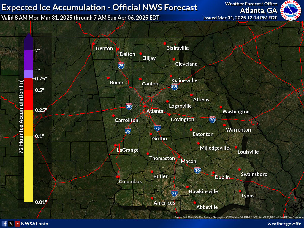
Not sure I want the FFC forecast for ZR to verify. 0.35 across the CAD areas after snow is going to be a huge power issue.
Look at the cooling over the midlands of SC
Tsappfrog20
Member
NWS Raleigh Pulled the Trigger!!

Sent from my iPhone using Tapatalk

Sent from my iPhone using Tapatalk
NWMSGuy
Member
Will be interesting to be in some of those heavy bands come early morning tomorrow. Wouldn't mind hearing a clap of thunder too!
Wet 

dsaur
Member
Yea, Kffc seems to be leaning away from Mr. super conservative Cook. We'll know more when the precip gets into Ala. I still think I get a pretty good sleet out of this, with a few inches of snow and a nice zr crust. Hopefully not enough to crash the trees. Been there too many times and don't like it. Sleet, sleet, sleet...If that Low goes true Miller A as most recent runs have showed some variant toward that and other models follow suit FFC will be quickly updating there Warnings haha
lexxnchloe
Member
Winter storm warning for a good portion of north central NC
Look at those sleet totals back in southern Arkansas. 3.5-4”. I’m not sure I’ve ever seen that much sleet modeled.HRRR makes a lot of sense...mainly snow NW of 85 and mix of sleet back to Raleigh/95. I'd take this all day.
View attachment 161949
ForsythSnow
Moderator
NAM running, still looks like it's on another planet in terms of thermal handling. It immediately jumps the verification to warmer ptypes.
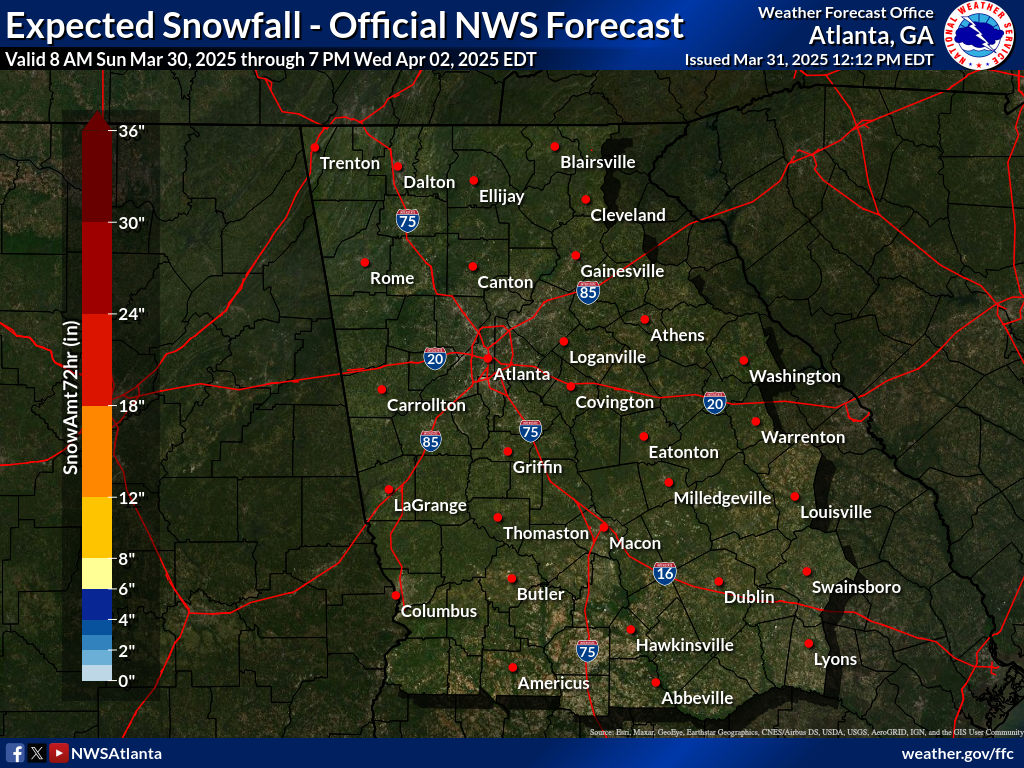
Latest snow/ice accumulations from FFC:
Either it's on to something or we're about to see more snow/sleet accumulations in AL/GA/SC/NC.NAM running, still looks like it's on another planet in terms of thermal handling. It immediately jumps the verification to warmer ptypes.
rburrel2
Member
Man if we can get the Hrrr to just tick colder one more time at 700mb then the upstate is easily all snow for the whole event. We're able to fight off any warm nose around 850mb from the residual cold pool. Just need that crest of that 750-800mb nose to tink one tiny click south.
I don’t think so, models have been trending colder for CAE Shawn. It look more possible that the central midlands could see a thump with that band.I-20 North. Better as you get into the Northern Midlands.
As usual, CAE proper gets crap.
I can't wait to move away from this state in the next year or so, lol.
Snow_chaser
Member
That’s what they say will accumulate. How much will actually fall because their numbers don’t match some of these juiced up precipitation maps lolLatest snow/ice accumulations from FFC:
Look at the cooling over the midlands of SC
The local office says the HRRR is too warm and it's basically ignored.
I am not surprised to see it 2F cooler than it's previous run.
A thump of half an inch of snow and sleet and then over to ZR up to 1/4 inch.I don’t think so, models have been trending colder for CAE Shawn. It look more possible that the central midlands could see a thump with that band.
Meh.
Let me know how 500mb and the track of the low supports a surprise 1-2 inch+ event in CAE and get back to me.
ForsythSnow
Moderator
It's snowing where the NAM has rain right now. I have 0 understanding on this model and just want to see how absurd it gets. Still a mess on it at hour 12. Hour 3 literally has rain in S AR.Either it's on to something or we're about to see more snow/sleet accumulations in AL/GA/SC/NC.
rburrel2
Member
Also, I kept thinking precip totals would go up along the escarpment of SC b/c the flow starts ripping out of the SE at 925mb Friday evening. There has to be some orographical enhancement with that. You can see it helps to adiabatically cool that layer as well already on the models
Let’s rage 
ForsythSnow
Moderator
Looks like 2013 + snow on top. Not sure the setup for that much ice exists.Latest snow/ice accumulations from FFC:
The NAM is on its own island with this system so far. That's all I need to know. Now, if it fits someones else's narrative, they will argue until they are blue in the face.
37F/15F Here right now.
37F/15F Here right now.
MichaelJ
Member
North of 85/40 in NC, it should be noted the dews are so low that it is desert dry and will take a while to overcome the virga as the levels of the atmosphere have to saturate. Could see it snowing on radar for a couple of hours with nothing hitting the ground. From GSO west, I think how ever much falls will be 90% sn and the rest IP