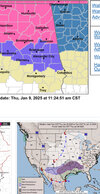
Nam is off its rocker with .7 + qpf here.
Most guidance is hugging .5
Ukmet and Icon ops still sit at .375.
The GFS, Canadian Brothers, Sref, other cams right at .5. Waiting on this Euro run.
NAM

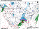
Sref

Most guidance is hugging .5
Ukmet and Icon ops still sit at .375.
The GFS, Canadian Brothers, Sref, other cams right at .5. Waiting on this Euro run.
NAM
Sref