The 3km NAM was still decent for N and NE Ga if you like ice baby ice with a little snow.
-
Hello, please take a minute to check out our awesome content, contributed by the wonderful members of our community. We hope you'll add your own thoughts and opinions by making a free account!
You are using an out of date browser. It may not display this or other websites correctly.
You should upgrade or use an alternative browser.
You should upgrade or use an alternative browser.
Wintry 1/9-12 Winter Potential Great Dane or Yorkie
- Thread starter SD
- Start date
Twister
Member
There's a reason why the NWS doesn't wait on the hi res Models to Put out Watches and warnings. Do you really think they Made their Forecast off those Models??
Haven't seen them postedAnyone have any information from the mogreps ukmet ensembles?


It's gotta be some kind of feedback from gulf/Mx convection going towards the trough and over amplifying right? I can't see jumping the entire state of Ms beyond realisticthis is nuts
Doing the lords work and saving Western NC !There's a reason why the NWS doesn't wait on the hi res Models to Put out Watches and warnings. Do you really think they Made their Forecast off those Models??
Snowflowxxl
Member
It’s the smoke in California now being sampled
Did it pick up some of the fire while it was at it???It’s the smoke in California now being sampled
Let's hope but you know as well as I, we can't just toss it because it's the NAM. This is certainly a possibility....naw can't happen right? Right?!It's gotta be some kind of feedback from gulf/Mx convection going towards the trough and over amplifying right? I can't see jumping the entire state of Ms beyond realistic
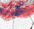
Texarkana stealing our snow in a big wayThis is pretty wild.
View attachment 161559

I’m at the gym, it’s leg day, can’t get a great look now, but agree it’s a rather extreme response for what looked like modest deepening of the desert wave at 5jIt's gotta be some kind of feedback from gulf/Mx convection going towards the trough and over amplifying right? I can't see jumping the entire state of Ms beyond realistic


snowlover91
Member
Brutal ice storm from 3k NAM.

If other models jump on this, then I'll worry. I've seen the Nam do this before.
Pops
Member
Can you show west please..sorry should be in other thread
I mean...I did haha. I've thought this was going to happen all along. Once these kind of trends start, if it is real (obviously will be interesting to see if RGEM picks up on this to this degree) it probably will keep going almost until go time. Boston could still be in play if this keeps going lol.It is hilarious… we probably should guessed this would happen. Doh
NEGaweather
Member

Sent from my iPhone using Tapatalk
Yes I do. And have. It may not happen, but I'm looking at H5 not the surface. If the H5 northern stream interactions go the way the NAM is showing, I definitely believe it and I posted about this earlier. It all starts to unravel with increased wind aloft eroding the insitu CAD allowing the wedge front to erode and the surface low to track inland along it. We're going down a rabbit hole that may not be this deep - but it also may be. Interesting 12-24 hours of model runs for sure coming up.I understand the NAM has for the most done a good job of finding issues in thermals, but do you really think we can give this track of the low that the NAM and HRRR any real weight when other modeling has not come close to showing anything like it. A NW trend is one thing, but these two models look like there trying to turn a southern slider into a cutter or Apps runner when nothing we’ve seen in the H5 set up supports it.
Nothing really has changed in a significant way with the NAM other than the h7 and 85 features but they magically go 750 miles NW? Seems weirdLet's hope but you know as well as I, we can't just toss it because it's the NAM. This is a certainly a possibility....naw can't happen right? Right?!
So that RAP run may not have been too crazy.
Snowflowxxl
Member
Sent from my iPhone using Tapatalk
Well he’s engagement hunting for $$$. Will tweet whatever drives the most traffic
Yeah, was just looking at that. The thing that really stands out is how the sheared out piece of the baja wave is so strong and overwhelming, and "ridgy". That's the question - is the NAM handling this piece correctly. If it is, it's bad news across the board....i.e. is the high resolution model able to pick up on this majestic subtropical ridging coming out of the baja wave. If it is, gotta keep that in the memory bank for future setups like thisThis is pretty wild.
View attachment 161559

Sent from my iPhone using Tapatalk


LovingGulfLows
Member
- Joined
- Jan 5, 2017
- Messages
- 1,499
- Reaction score
- 4,100
Yes I do. And have. It may not happen, but I'm looking at H5 not the surface. If the H5 northern stream interactions go the way the NAM is showing, I definitely believe it and I posted about this earlier. It all starts to unravel with increased wind aloft eroding the insitu CAD allowing the wedge front to erode and the surface low to track inland along it. We're going down a rabbit hole that may not be this deep - but it also may be. Interesting 12-24 hours of model runs for sure coming up.
Interesting so the wedge could potentially backfire on us because the winds aloft would create a baroclinic boundary along the retreating wedge that the low pressure would then ride. Always finding new ways to fail.
snowlover91
Member
Closeup Fv3 snow total map for those interested. 
Brent
Member
All those years of bad trends(even Sunday trended bad here) and snow holes
I mean... I don't buy it but what a way to turn things around if it did verify

We track this for 2 weeks and inside 48hrs we either have what the nam is showing or this
NWMSGuy
Member
Here, sitting two counties south of Memphis, TN during this court battle and trying to figure out who the hell is about to have custody of this damn snow storm/ rain line! I’ll tell you one difference between weather people and people who don’t really care about the weather until they have too. THEY, go to the grocery store when an event is approaching…us weather people go to the liquor store. 
Sorry if it’s already posted! 0z HRRR looks great

SnowNiner
Member
Closeup Fv3 snow total map for those interested. View attachment 161573
Yeah, this lines up with Euro, Ukmet, and RGEM. I doubt the NAM is reality. It looks like it almost went negative tilt in TX. We would have had to seen that possibility in the globals I would think by now.
Six Mile Wx
Member
We’re gonna need to see some other models with 0z data. Not sure if the NAM model is out to lunch or if the observational data has changed! Hurry up 0z Euro!
Last edited:
that was my same thinking.considering how the NAM sends the low so far NW, I’m surprised how cold it is at the sfc through the I20 corridor. Would’ve thought that track would mean the surface would be a blowtorch.
Tsappfrog20
Member
Will probably stay up for gfs then go to bed I need the gfs to come in clutch tonight lol never thought I would say that
Sent from my iPhone using Tapatalk
Sent from my iPhone using Tapatalk
Thank you. You’ve obviously studied this as a meteorologist and I certainly respect that. I just don’t remember ever seeing a model be so different from all other modeling so close to a storm starting and be right.Yes I do. And have. It may not happen, but I'm looking at H5 not the surface. If the H5 northern stream interactions go the way the NAM is showing, I definitely believe it and I posted about this earlier. It all starts to unravel with increased wind aloft eroding the insitu CAD allowing the wedge front to erode and the surface low to track inland along it. We're going down a rabbit hole that may not be this deep - but it also may be. Interesting 12-24 hours of model runs for sure coming up.
RTRwx
Member
Well. The WRF has an apps runner now too.
RTRwx
Member
Well. The WRF has an apps runner now too.

you may not need to wait that longWe’re gonna need to see some other models with 0z data. Not sure if the model is out to lunch or if the observational data has changed! Hurry up 0z Euro!