NBAcentel
Member
Boom 

Too late, we already have the snow map!!0z ICON warmer at the surface over Miss./Ark/western TN.
I wish that high pressure was a little bit further north and a few milibars stronger but otherwise this looks good for most of us.Nevermind!
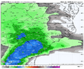
View attachment 160597
And she's a beaut, Clark!Too late, we already have the snow map!!
The way the moisture pokes forward like an arrow over Georgia is something that I always look for to get a good FGEN forced band set up over the SC upstate and NC southern Piedmont once it overruns the heart of the CAD. If you look back at radars of some of our best storms, they’ve had that signature… February 2004 is a good example
What helped with the track ? Negative tilt earlier, block not shifting as much east? At work and don’t have much time to look at the model!Lord have mercy
View attachment 160600

And that lp track about 100 miles east or more to have some wiggle room when any inevitable NW trend commencesI wish that high pressure was a little bit further north and a few milibars stronger but otherwise this looks good for most of us.
Great trends. Seeing that dark purple almost right over me is intriguing.
Love to see those 6+ totals jump east. Could get really good this suite.

 RGEM
RGEM
Long story short gulf air is getting pulled up.That’s crazy how Florence and Myrtle Beach, SC and Wilmington, NC is showing nothing but there is indication of winter weather all around those locations. What gives?
Sent from my iPhone using Tapatalk
The biggest trend today has been for the northern stream to press down out ahead of the trailing wave and keep the storm track right along the Gulf Coast and just offshore the southeast coast. This ICON run is the first one of the day that keeps you and me snow for the whole storm.What helped with the track ? Negative tilt earlier, block not shifting as much east? At work and don’t have much time to look at the model!


But we stay all frozen with this run. Great trend.Man, that Wake county gradient is steeeeeep.
Euro AI will gain legendary status if we get a board wide snow here. We will be talking about how it nailed this storm in the 2030s lolWe’re making adjustments on that icon run to what the big AI runs had about 3-4 days at H5
Good time to remind everyone of the above and if you wondering why some of your post got deletedWelcome to all our new members over the last several days we are glad you are here! Over the coming days this thread may become extremely active, there will be numerous members giving PBP as the models run and from many different locations across the area, it can become chaotic. With that said, I'd like to give a friendly reminder of our guidelines that can be found here https://southernwx.com/community/threads/community-guidelines.1338/#post-739672 , if you have not done so please take a few minutes to familiarize yourself with these.
Also please please refrain from the one liner comments that do not add substance to the discussion, these will be deleted (especially during time models are running), our banter threads are the places for these. If you have questions do not hesitate to PM one of the admins and/or Mods. Thank you for flying with Southernwx, buckle up and enjoy the ride!


Imagine when the northwest trend kicks in.Man, so close to greatness
View attachment 160602
Give us your thoughts on today's trends. This stronger northern stream interaction has everybody's attention. However, the GFS gives us pause.Absolutely playing with fire.
View attachment 160609