bouncycorn
Meteorologist
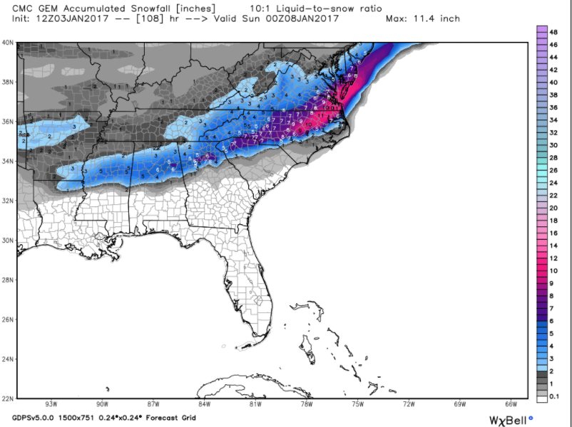
Canadian phases the second northern stream influx with our shortwave
Yeah CMC starts to bomb off GA coastWebberweather53 said:Here's what I'm talking about. That ULL over great lakes starts to dig considerably further southwestward than the previous run and phases with this once it gets to GA. Although this run may miss wide right (GFS progressive bias may be partially to blame) it highlights the fact there's definitely a risk of a huge coastal Miller A bomb off the Carolinas and VA... If we see the same trend with this feature that we observed with the first northern stream disturbance that's going to shear this out a little over the Pacific northwest and northern Rockies in the next day or so (w/ NS disturbance trending deeper, further SW), could get mighty interesting to say the least in the Carolinas & Mid-Atlantic

This will probably happen screwing CAE as usual.Brick Tamland said:Canadian looks good for here.
That's more like it! GFS is pulling a clown on us againBrick Tamland said:Canadian looks good for here.
Shawn said:Well. Canadian is a swing and miss for CAE. We do see some Wintry weather, but its mainly to our North.
Brick Tamland said:Canadian looks good for here.
whatalife said:Shawn said:Well. Canadian is a swing and miss for CAE. We do see some Wintry weather, but its mainly to our North.
Temps are off IMO
Sent from my iPhone using Tapatalk
Also, if this starts to phase sooner, wouldn't that put alot more people in play?tellicowx said:Yeah CMC starts to bomb off GA coastWebberweather53 said:Here's what I'm talking about. That ULL over great lakes starts to dig considerably further southwestward than the previous run and phases with this once it gets to GA. Although this run may miss wide right (GFS progressive bias may be partially to blame) it highlights the fact there's definitely a risk of a huge coastal Miller A bomb off the Carolinas and VA... If we see the same trend with this feature that we observed with the first northern stream disturbance that's going to shear this out a little over the Pacific northwest and northern Rockies in the next day or so (w/ NS disturbance trending deeper, further SW), could get mighty interesting to say the least in the Carolinas & Mid-Atlantic
Sent from my SM-S820L using Tapatalk
I'm using a blend of the GFS model for the tempswhatalife said:Shawn said:Well. Canadian is a swing and miss for CAE. We do see some Wintry weather, but its mainly to our North.
Temps are off IMO
Sent from my iPhone using Tapatalk
Shawn said:whatalife said:Shawn said:Well. Canadian is a swing and miss for CAE. We do see some Wintry weather, but its mainly to our North.
Temps are off IMO
Sent from my iPhone using Tapatalk
I closed it when it didn't show a big hit as I thought it would for us. I'd figure the low is too close/too much warm air advection over our way.

Bham 99 said:I am in Birmingham currently, and have lived in North Georgia also. I would say that we are due for a more southerly track, it has not happened in a while from what I remember over the past few years...
Storm5 said:I mean why are we worrying about temps off an unreliable model 3-4 days out . it's kinda obvious the gfs is on its own at the model . Eric brought up a good point about the gfs being too progressive.
God I need some tequila . gonna be along 4 days
better get the wife some wine incase we are snowed in
Sent from my SM-G900V using Tapatalk
tellicowx said:Also, if this starts to phase sooner, wouldn't that put alot more people in play?tellicowx said:Yeah CMC starts to bomb off GA coastWebberweather53 said:Here's what I'm talking about. That ULL over great lakes starts to dig considerably further southwestward than the previous run and phases with this once it gets to GA. Although this run may miss wide right (GFS progressive bias may be partially to blame) it highlights the fact there's definitely a risk of a huge coastal Miller A bomb off the Carolinas and VA... If we see the same trend with this feature that we observed with the first northern stream disturbance that's going to shear this out a little over the Pacific northwest and northern Rockies in the next day or so (w/ NS disturbance trending deeper, further SW), could get mighty interesting to say the least in the Carolinas & Mid-Atlantic
Sent from my SM-S820L using Tapatalk
Sent from my SM-S820L using Tapatalk
Shawn said:Well. Canadian is a swing and miss for CAE. We do see some Wintry weather, but its mainly to our North.
held serve looks like previous runs. would get a similar cmc solutionHartselleWeather said:What the the ukmet say about the storm?