I don’t think I can remember a time where all of the southeast is in the midst of a snow storm with temps in the teens and low 20s across most of the area … the rates would be absolutely insanely efficient at making snow.. I wonder how much moisture we end up being able to work with after this run is done.Temps during this are brutal, cold air once again not looking like a issue View attachment 106032
-
Hello, please take a minute to check out our awesome content, contributed by the wonderful members of our community. We hope you'll add your own thoughts and opinions by making a free account!
You are using an out of date browser. It may not display this or other websites correctly.
You should upgrade or use an alternative browser.
You should upgrade or use an alternative browser.
Wintry 1/20 - 1/23 Winter Storm
- Thread starter packfan98
- Start date
Snowflowxxl
Member
One word for that EURO run…. DAMN
I would imagine this EPS mean Is about to look even better than 0z
And still going! Good god the temperatures after this storm will break all time lows with that snow pack.
Iceagewhereartthou
Member
Meh, too far East!
?
What in the world!
Just way too early for those bullseyes.One word for that EURO run…. DAMN

Cadi40
Member
Where have I heard this from before Hmm..Temps during this are brutal, cold air once again not looking like a issue View attachment 106032
NBAcentel
Member
That PNA ridge is pretty insane, please give me suppression tho 
January 2014First in: that Feb ‘73 look!

.png")
.png")
NBAcentel
Member
There’s a difference between a bad storm track/H5, and cold air available around us tho,Where have I heard this from before Hmm..
Is 120-150 fantasy land now?
yes. at 120-150h hours out for tomorrows event the GFS/Euro were both showing big snow event for NC....how did that work out
So, that was fun and really nice to look at. But other than model bias, what mechanism is realistically responsible for suppressing the flow and allowing such a deep penetration of arctic air? Is the western ridge anomalous high? Or do we have a strong -AO/-NAO?
Cadi40
Member
While that’s true I’m just keeping my expectations at bay. Perhaps this will be a surprise storm for those of us who won’t have power to track it.There’s a difference between a bad storm track/H5, and cold air available around us tho,
Well, this ensures there will be some late nighters tonight
Flashback to 15 years ago, and me and SD debating the ideal placement of the western ridgeThat PNA ridge is pretty insane, please give me suppression tho View attachment 106037
The only thing I don't like is that the CMC and Euro are already amping things up and we still have 144+ hours to go. This would be downright amazing if this was only 36-48 hours out. However we know based on this weekends storm is that Models trend to amp things up and move the low pressure futher west as we get closer to go time. I would like to see more suppression from both the Euro and the CMC within the next 1-2 runs.
Last edited:
whatalife
Moderator
Yep. I would like it to suppressed too. The NW trend will show in a few days (imo).That PNA ridge is pretty insane, please give me suppression tho View attachment 106037
EastAtlwx
Meteorologist
That's not what fantasy land means... there is still a huge storm tomorrow its just NW...yes. at 120-150h hours out for tomorrows event the GFS/Euro were both showing big snow event for NC....how did that work out
Snowflowxxl
Member
I would normally say it’s too early for us to be looking this good, but look at the temps!!! Cold air is plentiful
Agree???The only thing I don't like is that the CMC and Euro are already amping things up and we still 144+ hours to go. This would downright amazaing if they was only 36-48 hours out. However we know based on this weekends storm is that Models trend to amp things up and move the low presssure futher west as we get closer to go time. I would to see more suppression from both the Euro and the CMC within the next 1-2 runs.
D
Deleted member 609
Guest
Looks good to me

NBAcentel
Member
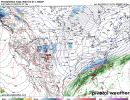
One thing that gets me with this one is that while we could still possibly trend the worst possible way with this, the energy/high is already dropping out of Canada/the pac at hour 78-96

Suped up 2010 storm knowing we are gonna get a west trend. I may not be alive by verification.I would normally say it’s too early for us to be looking this good, but look at the temps!!! Cold air is plentiful
Jessy89
Member
Upstate could bullseye be a 88 type storm. Because there always a nw trend
Sent from my iPhone using Tapatalk
Sent from my iPhone using Tapatalk
Hypsometric
Member
This setup really isn’t that complex. It’s overrunning precip over an Arctic front. Now the range of possibilities can be from the GFS/UKMET to the Euro depending on how much shortwave energy interacts with the natural baroclincity offered by the Arctic front.One thing that gets me with this one is that while we could still possibly trend the worst possible way with this, the energy/high is already dropping out of Canada/the pac at hour 78-96View attachment 106042View attachment 106043
NBAcentel
Member
Just a temps in the 20s sleet storm here now tonightAh yes another “temps in the 20s” snowstorm. Pretty sure we heard this about tonight’s storm and look where we are now.
The WPC is already highlighting day 7.

NBAcentel
Member
??
I have always said for a good snow storm around here, mainly south of the I-20 and I-85 corridors we need an Arctic front to drive down to I-10, then let a wave ride along that front/boundary and boom...There you have what the doc said. Will be fun to see play out.
NBAcentel
Member
This thing imo needs to be suppressed for longer, this setup Involves the western Atlantic ridge
whatalife
Moderator

whatalife
Moderator


pcbjr
Member
Point of potential correction ... I-4 to be more hopeful ...I have always said for a good snow storm around here, mainly south of the I-20 and I-85 corridors we need an Arctic front to drive down to I-10, then let a wave ride along that front/boundary and boom...There you have what the doc said. Will be fun to see play out.


The temps on euro right after and during the fantasy storm are simply insane. Many NC locations below 20 for over 24 hours
Good point! Sorry!Point of potential correction ... I-4 to be more hopeful ...
NBAcentel
Member
