Now this is accumulating snow wonder how long we can keep it up now 


Darn it did my m-ping expire? Hold on

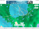
Yes it’s very cold rain coming down here in Mount Pleasant. Air
feels just a bit more frigid than an hour ago. Maybe we will see some snow.
Sent from my iPhone using Tapatalk
Snow now coming down in Moncks Corner, SC north of Charleston. Not sticking yet though. About 34.5 still but dropping quick
Sent from my iPhone using Tapatalk
Any minute now…


I can confirm that in Mount pleasant it's a snow mix.PRELIMINARY LOCAL STORM REPORT
NATIONAL WEATHER SERVICE CHARLESTON SC
411 AM EST SAT JAN 29 2022
.TIME... ...EVENT... ...CITY LOCATION... ...LAT.LON
.DATE... ....MAG.... ..COUNTY LOCATION..ST.. ...SOURCE.
..REMARKS..
0410 AM SNOW 2 NE MOUNT PLEASANT 32.82N 79.84W
01/29/2022 E0.0 INCH CHARLESTON SC PUBLIC
THE PUBLIC IS REPORTING SNOW MIXING WITH RAIN IN MOUNT
PLEASANT.

I’m still up too and 100% glad I did. Beautiful 1/2” snow clinging to everything.But I thought this event was a fail. Boom. 3rd weekend with ground coverage View attachment 111540
Unfortunately fell asleep and slept thru the whole event, but good thing I’ve seen it snow plenty this winterI’m still up too and 100% glad I did. Beautiful 1/2” snow clinging to everything.