Z
Zander98al
Guest
Your getting my hopes up, I see a wisp of snow in north Alabama ?. I need my hopes squashed before they go upInteresting
View attachment 110386
Your getting my hopes up, I see a wisp of snow in north Alabama ?. I need my hopes squashed before they go upInteresting
View attachment 110386
So is this from phasing earlier?
Yea the sfc reflection should have been better then that tbhSo is this from phasing earlier?
Yeah we would definitely deal with mixing issues but that track, strength verbatim would crash the column on exit and probably go pound town before completely shutting off.
This almost makes me think those CIPS analogs have some merit. This is a healthy accumulating snow band. Already looks like higher rates than our past storm but the catch is "warmer" temps meaning ratios would most likely be less than what we had then.
I'd argue for more. Go back and look at the Euro run and how long eastern NC was showing snow even when the Low pressures was well north of the area.Looking at the RH numbers, the triangle still had at least six hours of snow left
Trying not to get excited, but that's a good NAM run considering what we've been seeing. If 18z gfs comes back we might have something to look at tomorrow after all. Certainly for the 0z suitesYeah we would definitely deal with mixing issues but that track, strength verbatim would crash the column on exit and probably go pound town before completely shutting off.

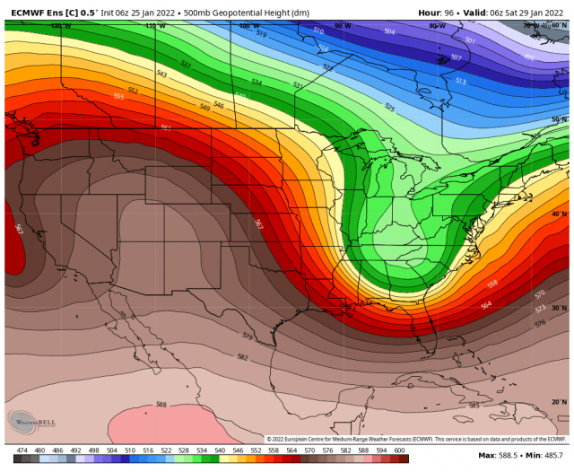
I am remembering last storm and how the HRRR and NAM almost every new run almost created a strong piece of energy out of nowhere as we went towards verification. If they did that with the last system what could happen here?The energy diving down on the back of the trough is a thing of beauty View attachment 110402
That and be careful what you wish for, you really don't want it to come to much further west and there's really nothing to guarantee it won't. The fine line we walk around hereThe only tempering and sobering thing about the 18z right now is the NAM can giveth and just as easily taketh away on the next run.
I would argue the opposite. The RGEM (all joking aside) was by far the best performing model for last storm. The NAM lost the storm completely 24-48 hours before the storm was suppose to happen. This time frame is suppose to be the NAM's "wheelhouse" I take everything the NAM puts out now with massive mounds of salt. Has no credibility in my eyes going forward other than to observe how its reacting to trends in other models.We can talk all the crap about the NAM we want to but it did pretty good with last week’s system. Not saying it’ll play out the same but it’s something to watch for sure.
Look at all that vort shrapnel off the coast. Love seeing that.The energy diving down on the back of the trough is a thing of beauty View attachment 110402
Well to be fair it had some crap runs that were wrong in the lead up but boy when it figured it out, it really figured it out.We can talk all the crap about the NAM we want to but it did pretty good with last week’s system. Not saying it’ll play out the same but it’s something to watch for sure.
The NAM was showing precip not even making it to the coast 48 hours out with last week’s system. What do you mean?We can talk all the crap about the NAM we want to but it did pretty good with last week’s system. Not saying it’ll play out the same but it’s something to watch for sure.
Yeah I can't stop staring at that mapLook at all that vort shrapnel off the coast. Love seeing that.
You want the big dog, that's what it looks like. It's very close to tucking the low into the coast. But it is the long range NAM. That said, I'm expecting a trend back to a big storm. Historic? Meh, that's impossible to call. But I think somebody in the SE up into VA is going to get smoked.Yeah I can't stop staring at that map
Never say never but honestly I think any expectations for this to bring alabama snow should be very tampered. I think the best places for this to trend better for them would be western NC and SCAre we gonna see constant trends up until go time with this system, like that last one that was on a Sunday? Seems like this is a new normal. If it keeps going we may see some snow in alabamur
Pretty much what @CaryWx is alluding to. Yes, it had some crap runs but other models have as well.The NAM was showing precip not even making it to the coast 48 hours out with last week’s system. What do you mean?
I get it and we've certainly got it--in the wrong way, but runs like the ICON has just revealed have me thinking -too far west- will not be what we have to contend withThat and be careful what you wish for, you really don't want it to come to much further west and there's really nothing to guarantee it won't. The fine line we walk around here
Not our storm, not our year.Are we gonna see constant trends up until go time with this system, like that last one that was on a Sunday? Seems like this is a new normal. If it keeps going we may see some snow in alabamur
